


Hurricane Sandy (Halloblizzard)
Page 7 of 14 •  1 ... 6, 7, 8 ... 10 ... 14
 ![]()
Re: Hurricane Sandy (Halloblizzard)
![]() by John1122 2012-10-26, 3:48 pm
by John1122 2012-10-26, 3:48 pm
John1122- Winter Specialist
- Posts : 885
Join date : 2011-12-06
Location : Campbell Co
Re: Hurricane Sandy (Halloblizzard)
![]() by John1122 2012-10-26, 3:51 pm
by John1122 2012-10-26, 3:51 pm
John1122- Winter Specialist
- Posts : 885
Join date : 2011-12-06
Location : Campbell Co
Re: Hurricane Sandy (Halloblizzard)
![]() by Toot 2012-10-26, 4:00 pm
by Toot 2012-10-26, 4:00 pm
The accumulation maps will change greatly each run...I wouldnt worry about those either. The important thing is stormcenter placement..it looks like we have reached the end of the west and south trend with the euro..if it starts trending north.. it will be time to worry about losing snowfall potential.
At this point.. I have no reason to doubt the euro's stormcenter placement as it has been super consistent with the Delmarva area!

Toot- La Vida Loca
- Posts : 6644
Join date : 2011-12-05
Location : Cocke County, TN -

Re: Hurricane Sandy (Halloblizzard)
![]() by Toot 2012-10-26, 4:20 pm
by Toot 2012-10-26, 4:20 pm

Toot- La Vida Loca
- Posts : 6644
Join date : 2011-12-05
Location : Cocke County, TN -
Re: Hurricane Sandy (Halloblizzard)
![]() by Toot 2012-10-26, 4:38 pm
by Toot 2012-10-26, 4:38 pm

This is a massive and very negatively tilted system..pressures are progged to break 93 superstorm records. I truly think the snowfall potential is not being stressed enough..especially in WV and SW VA. Its gonna take many people by surprise!
Toot- La Vida Loca
- Posts : 6644
Join date : 2011-12-05
Location : Cocke County, TN -
Re: Hurricane Sandy (Halloblizzard)
![]() by Adam2014 2012-10-26, 4:49 pm
by Adam2014 2012-10-26, 4:49 pm

Adam2014- Founding Member
- Posts : 1424
Join date : 2011-12-05
Age : 28
Location : Lawrenceburg,TN
Re: Hurricane Sandy (Halloblizzard)
![]() by Toot 2012-10-26, 4:55 pm
by Toot 2012-10-26, 4:55 pm
Sunday
A slight chance of rain showers before 11pm, then a slight chance of snow showers between 11pm and 2am. Mostly cloudy, with a low around 34. Chance of precipitation is 20%.
Right now they are saying just a couple of inches in the mountains..which I cant blame them..this type of system has never happened before and there are alot of unknowns. they clear cloud cover and precip out of the grids way too early monday morning.
Monday
Partly sunny, with a high near 47.
Toot- La Vida Loca
- Posts : 6644
Join date : 2011-12-05
Location : Cocke County, TN -

Toot- La Vida Loca
- Posts : 6644
Join date : 2011-12-05
Location : Cocke County, TN -
Re: Hurricane Sandy (Halloblizzard)
![]() by Toot 2012-10-26, 5:26 pm
by Toot 2012-10-26, 5:26 pm
Here is the latest spaghetti models..notice the tight grouping around the Delmarva.

Toot- La Vida Loca
- Posts : 6644
Join date : 2011-12-05
Location : Cocke County, TN -
Re: Hurricane Sandy (Halloblizzard)
![]() by snowdog 2012-10-26, 5:32 pm
by snowdog 2012-10-26, 5:32 pm
snowdog- Winter Specialist
- Posts : 855
Join date : 2011-12-14
Age : 46
Location : Mount Juliet, TN
Re: Hurricane Sandy (Halloblizzard)
![]() by skillsweather 2012-10-26, 5:40 pm
by skillsweather 2012-10-26, 5:40 pm
skillsweather- Banned
- Posts : 313
Join date : 2011-12-06
Age : 32
Location : tennessee Wilson county Ne Corner
Re: Hurricane Sandy (Halloblizzard)
![]() by snowdog 2012-10-26, 5:40 pm
by snowdog 2012-10-26, 5:40 pm
Toot wrote:I wont get many hours of sleep this weekend! I hope my posts dont get too annoying. Gonna be wall to wall coverage for me all weekend here..starting right now..lol
 I'll be reading. I really have no idea how this is going to turn out. I can't even put a prediction on it. Some places could get absolutely crushed. It's going to be cool to see how this thing evolve (not only from a snow standpoint but the impacts from Sandy making landfall and where).
snowdog- Winter Specialist
- Posts : 855
Join date : 2011-12-14
Age : 46
Location : Mount Juliet, TN
Re: Hurricane Sandy (Halloblizzard)
![]() by Toot 2012-10-26, 5:45 pm
by Toot 2012-10-26, 5:45 pm
snowdog wrote:I wonder if, here in north middle-TN, we would get any "fetch" off the lakes up north since it looks like we will be under a heavy north wind for a while.
I wouldnt surprise me Snowdog but cold advection is certainly weaker the more west you are. I hope we both at least get to see some flakeage. I just realized why the 12zeuro shows less snow than the 0Z does over here in eastern TN. When the 12z landfalls it really doesnt retrograde..it just pulls off to the NE taking the snow with it. This is the first run of the euro to show this
Here is the 0z at 120hrs

Here is the 12z at 120..this is as far west as the euro takes the low
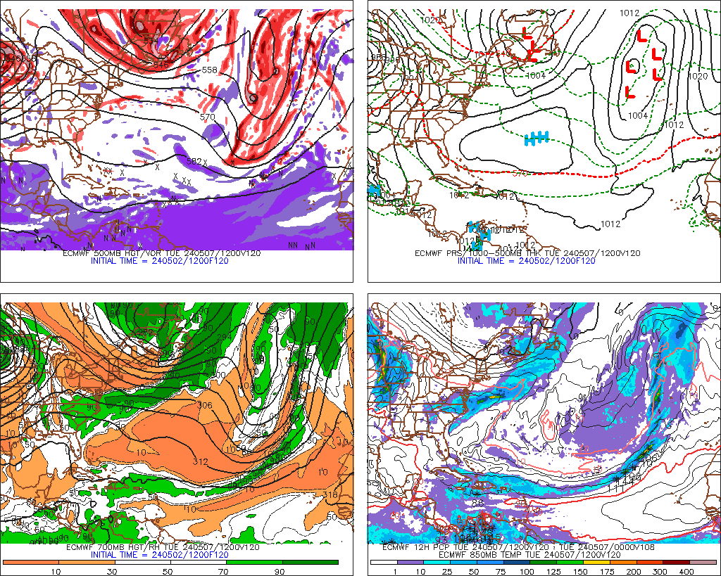
At 144 its centred up near Maine
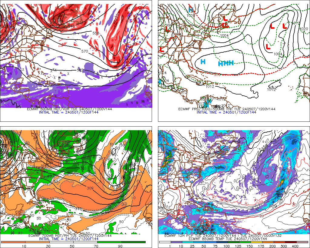
Most models in the euro camp retrograde the low much further west...well see if that was just a hiccup or if its onto something
Toot- La Vida Loca
- Posts : 6644
Join date : 2011-12-05
Location : Cocke County, TN -
Re: Hurricane Sandy (Halloblizzard)
![]() by Toot 2012-10-26, 5:51 pm
by Toot 2012-10-26, 5:51 pm
skillsweather wrote:Highs will be in the 50's so even if we get moisture here it would only be snow for a few hours during the night.
50's are not gonna happen in middle or eastern TN Monday or Tuesday
Toot- La Vida Loca
- Posts : 6644
Join date : 2011-12-05
Location : Cocke County, TN -
Re: Hurricane Sandy (Halloblizzard)
![]() by Toot 2012-10-26, 6:14 pm
by Toot 2012-10-26, 6:14 pm


Toot- La Vida Loca
- Posts : 6644
Join date : 2011-12-05
Location : Cocke County, TN -

Toot- La Vida Loca
- Posts : 6644
Join date : 2011-12-05
Location : Cocke County, TN -
Re: Hurricane Sandy (Halloblizzard)
![]() by Stovepipe 2012-10-26, 7:15 pm
by Stovepipe 2012-10-26, 7:15 pm
Toot wrote:Cold front..This is Sandy!! Sandy.. meet Cold Front!
It's beautiful!!

Stovepipe- Founding Member
- Posts : 4148
Join date : 2011-12-05
Age : 48
Location : Knoxville, TN -
Re: Hurricane Sandy (Halloblizzard)
![]() by etnwx 2012-10-26, 7:26 pm
by etnwx 2012-10-26, 7:26 pm
Toot wrote:I wont get many hours of sleep this weekend! I hope my posts dont get too annoying. Gonna be wall to wall coverage for me all weekend here..starting right now..lol
Here is the latest spaghetti models..notice the tight grouping around the Delmarva.
Won't be annoying to me. In fact I'll be checking every few hours myself looking for updates.


etnwx- Storm Spotter
- Posts : 313
Join date : 2012-10-25
Age : 55
Location : NW Knox County -
Re: Hurricane Sandy (Halloblizzard)
![]() by Toot 2012-10-26, 7:56 pm
by Toot 2012-10-26, 7:56 pm
Definately more unknowns than usual with this setup...For the life of me.. I just cant see how WV doesnt get literally buried.. if the euro is correct!snowdog wrote:
Lol..there should be plenty of fresh info here...Ive devoted my whole weekend to tracking this system online. I will probably break to sleep a few hours each night..but im pretty much glued to guidance and real time dataetnwx wrote:
Won't be annoying to me. In fact I'll be checking every few hours myself looking for updates.

Toot- La Vida Loca
- Posts : 6644
Join date : 2011-12-05
Location : Cocke County, TN -
Re: Hurricane Sandy (Halloblizzard)
![]() by snowdog 2012-10-26, 8:15 pm
by snowdog 2012-10-26, 8:15 pm
Toot wrote:Definately more unknowns than usual with this setup...For the life of me.. I just cant see how WV doesnt get literally buried.. if the euro is correct!
I agree about WV. What makes it so hard to predict, for me, is the time of year the storm is occurring. For us, being this far south, it is just real hard to get enough cold air and it really takes a very anomalous type set-up. This system is obviously one of those very anomalous type systems but it is going to be one of those dynamic type set-ups and who knows where that is going to set-up. Watching models for "where will the snow be" isn't going to do much good as it will probably be more a nowcast type deal for those of us in the upper south.
snowdog- Winter Specialist
- Posts : 855
Join date : 2011-12-14
Age : 46
Location : Mount Juliet, TN
Re: Hurricane Sandy (Halloblizzard)
![]() by Toot 2012-10-26, 8:26 pm
by Toot 2012-10-26, 8:26 pm
snowdog wrote:
Watching models for "where will the snow be" isn't going to do much good as it will probably be more a nowcast type deal for those of us in the upper south.
Totally agree..especially since its a phasing situation. Time and time again there have been critical changes right at the last minute due to a models not handling phasing correctly. I wouldnt think about making anykind of calls for specific snow amounts at this point. The "It being October fact" really could play a big role in keeping precip in liquid form in several unelevated spots! At the same time.. such a powerful and anomalous storm could dump several inches in unelevated spots in NE TN. Its really that fine of a line..its gonna be fun seeing who racks up..somebody definately will with this system.
Last edited by Toot on 2012-10-26, 8:45 pm; edited 1 time in total
Toot- La Vida Loca
- Posts : 6644
Join date : 2011-12-05
Location : Cocke County, TN -
Re: Hurricane Sandy (Halloblizzard)
![]() by Stovepipe 2012-10-26, 8:43 pm
by Stovepipe 2012-10-26, 8:43 pm
Yeah, this is fascinating to watch in so many ways. Regardless of whether I will even have flakes within driving distance or not, it's amazing to see this system come together. People seem to be taking it seriously too, and it's a good thing as it's likely to become a dangerous situation on the east coast and possibly inland. Mother Nature likes to throw curve balls doesn't she?
Stovepipe- Founding Member
- Posts : 4148
Join date : 2011-12-05
Age : 48
Location : Knoxville, TN -
Re: Hurricane Sandy (Halloblizzard)
![]() by Toot 2012-10-26, 11:06 pm
by Toot 2012-10-26, 11:06 pm
Toot- La Vida Loca
- Posts : 6644
Join date : 2011-12-05
Location : Cocke County, TN -
Re: Hurricane Sandy (Halloblizzard)
![]() by Toot 2012-10-26, 11:31 pm
by Toot 2012-10-26, 11:31 pm

It usually shows zilch even during surefire events
Toot- La Vida Loca
- Posts : 6644
Join date : 2011-12-05
Location : Cocke County, TN -
Re: Hurricane Sandy (Halloblizzard)
![]() by Toot 2012-10-26, 11:37 pm
by Toot 2012-10-26, 11:37 pm
Toot- La Vida Loca
- Posts : 6644
Join date : 2011-12-05
Location : Cocke County, TN -
Page 7 of 14 • 1 ... 6, 7, 8 ... 10 ... 14 ![]()
» Hurricane Isaac
» WXeastern/Toots 2013 Hurricane season forecast
» Irene was tropical storm, not hurricane, over NJ
» Frankies 2012 Hurricane season Forecast


