


January 24-25th Clipper/Ice Ice Baby
Page 2 of 15 •  1, 2, 3 ... 8 ... 15
 ![]()
Re: January 24-25th Clipper/Ice Ice Baby
![]() by Toot 2013-01-20, 4:33 pm
by Toot 2013-01-20, 4:33 pm
Where any secondary low might develop is anyones guess at this point tho

Toot- La Vida Loca
- Posts : 6644
Join date : 2011-12-05
Location : Cocke County, TN -

Re: January 24-25th Clipper/Ice Ice Baby
![]() by ballpark 2013-01-20, 5:39 pm
by ballpark 2013-01-20, 5:39 pm
We usually do pretty well in N TN from Clipper type systems this time of year. Maybe we will have an better ideal after we get inside the 84hr window.Toot wrote:Yeah..ensembles are still all over the place. Probably still need some better data ingested into the models. The chances of TN seeing significant snowfall from this system is still pretty low. I still look for of a clipper system more so than a lakes cutter.
Where any secondary low might develop is anyones guess at this point tho
ballpark- Banned
- Posts : 155
Join date : 2011-12-07
Location : White House -
Re: January 24-25th Clipper/Ice Ice Baby
![]() by tennessee storm09 2013-01-20, 6:23 pm
by tennessee storm09 2013-01-20, 6:23 pm
tennessee storm09- Severe Wx Specialist
- Posts : 1304
Join date : 2011-12-05
Age : 61
Location : jackson,tennessee(home of 3 ef4 tornadoes since 1999)
Re: January 24-25th Clipper/Ice Ice Baby
![]() by Jscentraltn 2013-01-20, 6:41 pm
by Jscentraltn 2013-01-20, 6:41 pm


Jscentraltn- Admin
- Posts : 703
Join date : 2013-01-19
Age : 45
Location : Cheatham county
Re: January 24-25th Clipper/Ice Ice Baby
![]() by Toot 2013-01-20, 6:50 pm
by Toot 2013-01-20, 6:50 pm
Agreed..and clippers can definately be the one of the most surprising types of storm system around here. I love a good clipper storm..they only seem to be around just a few weeks outta the year! That may have something to do with my infatuation with them...or it might just be all their cool namesballpark wrote: We usually do pretty well in N TN from Clipper type systems this time of year. Maybe we will have an better ideal after we get inside the 84hr window.
"Alberta Clipper"
"Mantioba Mauler"
"Saskatchewan Screamer"

Toot- La Vida Loca
- Posts : 6644
Join date : 2011-12-05
Location : Cocke County, TN -
Re: January 24-25th Clipper/Ice Ice Baby
![]() by Jscentraltn 2013-01-20, 7:05 pm
by Jscentraltn 2013-01-20, 7:05 pm

Jscentraltn- Admin
- Posts : 703
Join date : 2013-01-19
Age : 45
Location : Cheatham county
Re: January 24-25th Clipper/Ice Ice Baby
![]() by Toot 2013-01-20, 8:02 pm
by Toot 2013-01-20, 8:02 pm
Could the DGEX pull a coupe de gras?


Toot- La Vida Loca
- Posts : 6644
Join date : 2011-12-05
Location : Cocke County, TN -
Re: January 24-25th Clipper/Ice Ice Baby
![]() by Jscentraltn 2013-01-20, 9:07 pm
by Jscentraltn 2013-01-20, 9:07 pm
It would be nice if the low dives further south and slams Tennessee. But I think kentucky/indi are the ones in line. We will see by wed/thur time frameToot wrote:HPC has flights into the upper level energy of this thing for the next three days. They evidently think there is potential for a major snowstorm somewhere. Where being the keyword here..LOL!
Could the DGEX pull a coupe de gras?

Jscentraltn- Admin
- Posts : 703
Join date : 2013-01-19
Age : 45
Location : Cheatham county
Re: January 24-25th Clipper/Ice Ice Baby
![]() by Jed33 2013-01-21, 6:53 am
by Jed33 2013-01-21, 6:53 am
I might add, that 6z is kinda funny, but it doesn't bring in quite as much cold as the euro. Using phone, so can't post graphics. Interesting that the gfs, a model with a cold bias has been playing catch up to the euro lately.
Jed33- Admin
- Posts : 930
Join date : 2011-12-09
Location : Morristown, TN
Re: January 24-25th Clipper/Ice Ice Baby
![]() by John1122 2013-01-21, 7:35 am
by John1122 2013-01-21, 7:35 am
John1122- Winter Specialist
- Posts : 885
Join date : 2011-12-06
Location : Campbell Co
Re: January 24-25th Clipper/Ice Ice Baby
![]() by John1122 2013-01-21, 7:42 am
by John1122 2013-01-21, 7:42 am
John1122- Winter Specialist
- Posts : 885
Join date : 2011-12-06
Location : Campbell Co
John1122- Winter Specialist
- Posts : 885
Join date : 2011-12-06
Location : Campbell Co
Re: January 24-25th Clipper/Ice Ice Baby
![]() by destair 2013-01-21, 7:55 am
by destair 2013-01-21, 7:55 am
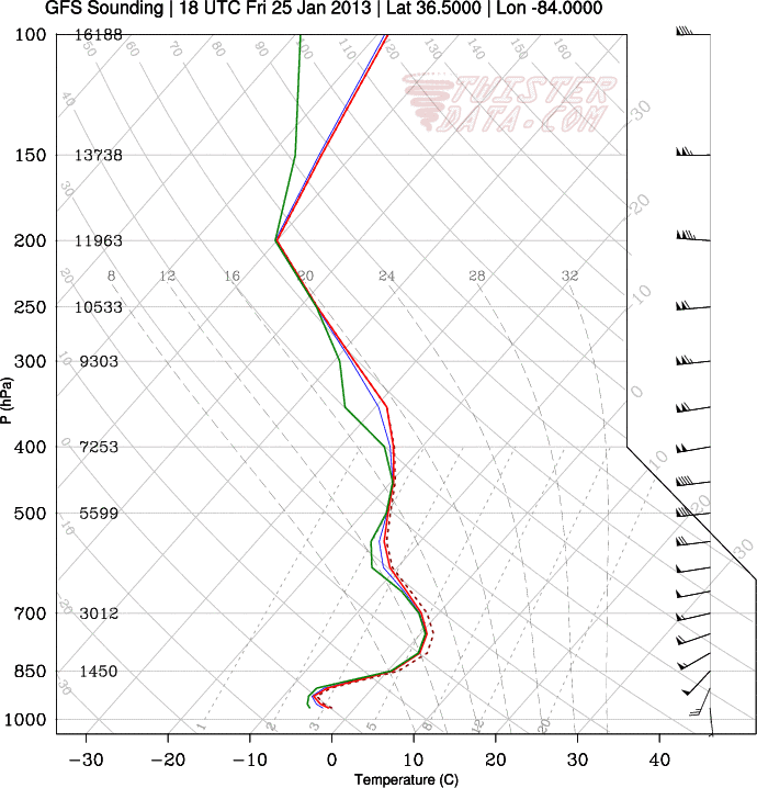
Where do yo look that tells you the precipitation will be ice?
destair- Member
- Posts : 5
Join date : 2013-01-13
Re: January 24-25th Clipper/Ice Ice Baby
![]() by John1122 2013-01-21, 8:04 am
by John1122 2013-01-21, 8:04 am
On the sounding I posted you see the column above freezing just above 850mb. The surface temp is about -2c which is around 28. The column being that cold from 850 to the surface would suggest sleet.
John1122- Winter Specialist
- Posts : 885
Join date : 2011-12-06
Location : Campbell Co
Re: January 24-25th Clipper/Ice Ice Baby
![]() by destair 2013-01-21, 8:06 am
by destair 2013-01-21, 8:06 am
destair- Member
- Posts : 5
Join date : 2013-01-13
Re: January 24-25th Clipper/Ice Ice Baby
![]() by ballpark 2013-01-21, 8:28 am
by ballpark 2013-01-21, 8:28 am
ballpark- Banned
- Posts : 155
Join date : 2011-12-07
Location : White House -
Re: January 24-25th Clipper/Ice Ice Baby
![]() by Toot 2013-01-21, 8:38 am
by Toot 2013-01-21, 8:38 am
John1122 wrote:Sounding 1 pm Friday.
 Sleetstorm
http://www.tnweatherspot.com/t95-how-to-read-a-skew-t-chart-soundingdestair wrote:Thank you. I'm a complete amateur but very interested in learning how to interpret the soundings and models.
Toot- La Vida Loca
- Posts : 6644
Join date : 2011-12-05
Location : Cocke County, TN -
Re: January 24-25th Clipper/Ice Ice Baby
![]() by destair 2013-01-21, 9:02 am
by destair 2013-01-21, 9:02 am
Toot wrote:John1122 wrote:Sounding 1 pm Friday.http://www.tnweatherspot.com/t95-how-to-read-a-skew-t-chart-soundingdestair wrote:Thank you. I'm a complete amateur but very interested in learning how to interpret the soundings and models.
This helps. Thanks.
destair- Member
- Posts : 5
Join date : 2013-01-13
Re: January 24-25th Clipper/Ice Ice Baby
![]() by jmundie 2013-01-21, 10:15 am
by jmundie 2013-01-21, 10:15 am
jmundie- Winter Specialist
- Posts : 743
Join date : 2011-12-19
Re: January 24-25th Clipper/Ice Ice Baby
![]() by ballpark 2013-01-21, 1:10 pm
by ballpark 2013-01-21, 1:10 pm
The 12z shifted the low back North. What do the 12z ensembles show?jmundie wrote:6z ensembles have some especially awesome looks.
ballpark- Banned
- Posts : 155
Join date : 2011-12-07
Location : White House -
Re: January 24-25th Clipper/Ice Ice Baby
![]() by jmundie 2013-01-21, 1:42 pm
by jmundie 2013-01-21, 1:42 pm

jmundie- Winter Specialist
- Posts : 743
Join date : 2011-12-19
Re: January 24-25th Clipper/Ice Ice Baby
![]() by Jed33 2013-01-21, 2:17 pm
by Jed33 2013-01-21, 2:17 pm
Jed33- Admin
- Posts : 930
Join date : 2011-12-09
Location : Morristown, TN
Re: January 24-25th Clipper/Ice Ice Baby
![]() by ballpark 2013-01-21, 2:20 pm
by ballpark 2013-01-21, 2:20 pm
ballpark- Banned
- Posts : 155
Join date : 2011-12-07
Location : White House -
Re: January 24-25th Clipper/Ice Ice Baby
![]() by Jscentraltn 2013-01-21, 5:56 pm
by Jscentraltn 2013-01-21, 5:56 pm

Jscentraltn- Admin
- Posts : 703
Join date : 2013-01-19
Age : 45
Location : Cheatham county
Re: January 24-25th Clipper/Ice Ice Baby
![]() by Toot 2013-01-21, 6:00 pm
by Toot 2013-01-21, 6:00 pm
Graphics posted in the members section.
Toot- La Vida Loca
- Posts : 6644
Join date : 2011-12-05
Location : Cocke County, TN -
Page 2 of 15 • 1, 2, 3 ... 8 ... 15 ![]()
» dec 25th trough dec 30th
» Clipper Train 2013
» Clipper Train 2014
» Jan 12th-15th Clipper Systems


