
WRF cast

Satellite Loop

Current Snow Cover

Conus Radar

Regional Radar

Tennessee Radar

SE RADAR

24 hr Temp change

Regional Temps

Conus Temps

Current CPC NAO and forecast

Big Dog Call maps/Forecasts
4 posters
Page 1 of 1

Big Dog Call maps/Forecasts
![]() by Toot 2013-01-16, 8:01 pm
by Toot 2013-01-16, 8:01 pm
Alright here is my forecast
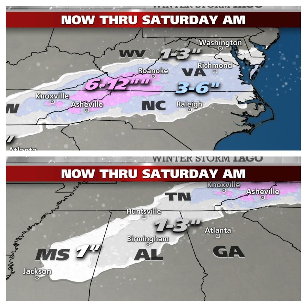
After a warm December old man winter is just getting started here in the eastern US. One the first products of this colder pattern is what I have called and continue to call a "Southern Slider" winter storm system. this winter storm will likely lay a swath of wet snow down from central/southern Mississippi all the way up towards the southern tip of New Jersey!
A strong upper level low/shortwave will swing into the southeastern states tonight where it will begin changing the rain associated with a stalled out surface boundary to snow. Snow could become heavy at times underneath the cold core of the upper low after midnight tonight in central and southern Mississippi and into the day tomorrow in central and northern Alabama.
At the surface a low begins to strengthen across eastern Georgia and as the upper low begins to dampen out and lose its forcing some of the lower valley locales in northern GA and southeastern TN could have trouble changing the rain over to snow.. but I expect it will eventually change.
As the surface low begins to move east-northeast the associated precip field will spread northward into more of a polar airmass moving in from the west. With the help of some upper level dynamics the rain will also change to snow there. This is where I expect the snow will become extremely heavy with very impressive snowfall rates.. especially in the southern Appalachian mountains where I expect trees will ultimately snap due to the high water content of the precip. Due to how dynamic this system is I will not be surprised to hear multiple reports of thundersnow too. Taking the latest guidance into consideration here is my updated/final forecast graphic.
Last edited by Toot on 2013-02-08, 10:27 pm; edited 2 times in total

Toot- La Vida Loca
- Posts : 6644
Join date : 2011-12-05
Location : Cocke County, TN -

Re: Big Dog Call maps/Forecasts
![]() by tom23 2013-01-16, 8:34 pm
by tom23 2013-01-16, 8:34 pm
Just so everyone knows, I am going to post what Toot said on his fb page regarding what the different levels of accumulations on his call map mean. Toot, feel free to delete this post if you don't feel like its my place to do so, but I just wanted to clear up some possible questions members that don't follow your fb page may have.
Light= Trace-3 inches
Moderate= 3-6 inches
Heavy= 6+
Light= Trace-3 inches
Moderate= 3-6 inches
Heavy= 6+
tom23- Founding Member
- Posts : 298
Join date : 2012-07-06
Age : 31
Location : Jefferson City, TN
Re: Big Dog Call maps/Forecasts
![]() by Jed33 2013-01-16, 9:31 pm
by Jed33 2013-01-16, 9:31 pm
That's a good call Toot! I love it! Here's hoping for snow tomorrow afternoon!  Assuming Knoxville does get more than 4in, when was the last time that happened? I didn't live here in 2009-2011, but seems like the heaviest during that time was 4in? I could be wrong though.
Assuming Knoxville does get more than 4in, when was the last time that happened? I didn't live here in 2009-2011, but seems like the heaviest during that time was 4in? I could be wrong though.
Jed33- Admin
- Posts : 930
Join date : 2011-12-09
Location : Morristown, TN
Re: Big Dog Call maps/Forecasts
![]() by etnwx 2013-01-16, 9:41 pm
by etnwx 2013-01-16, 9:41 pm
I remember 2 good 4" snows in 2006 January to February timeframe. In fact one was on 2/18, the day I got married.
We had another good snow since then, but I can't remember the year off hand.
We had another good snow since then, but I can't remember the year off hand.

etnwx- Storm Spotter
- Posts : 313
Join date : 2012-10-25
Age : 55
Location : NW Knox County -
Re: Big Dog Call maps/Forecasts
![]() by Toot 2013-01-16, 11:44 pm
by Toot 2013-01-16, 11:44 pm
DT (Wxrisk.com) has 3-6 in Knox county...6-9 in Morristown/Greeneville area 9-12 in the Bristol/Johnson City area. Which is possible but half of those totals is a very comfortable bet right now
Toot- La Vida Loca
- Posts : 6644
Join date : 2011-12-05
Location : Cocke County, TN -

Toot- La Vida Loca
- Posts : 6644
Join date : 2011-12-05
Location : Cocke County, TN -
» Met Office threatened with legal action over 'pessimistic' forecasts
» NOAA near-term weather forecasts get powerful boost from new computer model
» Live Weather Maps
» Tennessee County Formation Maps
» Call Map Thread for February 19th Storm
» NOAA near-term weather forecasts get powerful boost from new computer model
» Live Weather Maps
» Tennessee County Formation Maps
» Call Map Thread for February 19th Storm
Page 1 of 1
Permissions in this forum:
You cannot reply to topics in this forum


