


Winter 2011/2012 Pattern Discussion
Page 2 of 37 •  1, 2, 3 ... 19 ... 37
 ![]()
Re: Winter 2011/2012 Pattern Discussion
![]() by skillsweather 2011-12-09, 2:40 am
by skillsweather 2011-12-09, 2:40 am
skillsweather- Banned
- Posts : 313
Join date : 2011-12-06
Age : 32
Location : tennessee Wilson county Ne Corner
Re: Winter 2011/2012 Pattern Discussion
![]() by Stovepipe 2011-12-09, 9:04 am
by Stovepipe 2011-12-09, 9:04 am

Stovepipe- Founding Member
- Posts : 4148
Join date : 2011-12-05
Age : 48
Location : Knoxville, TN -

Re: Winter 2011/2012 Pattern Discussion
![]() by Reb 2011-12-09, 2:30 pm
by Reb 2011-12-09, 2:30 pm

Reb- Admin
- Posts : 745
Join date : 2011-12-05
Location : Maryville, TN
Re: Winter 2011/2012 Pattern Discussion
![]() by John1122 2011-12-09, 5:28 pm
by John1122 2011-12-09, 5:28 pm
John1122- Winter Specialist
- Posts : 885
Join date : 2011-12-06
Location : Campbell Co
Re: Winter 2011/2012 Pattern Discussion
![]() by Toot 2011-12-09, 6:41 pm
by Toot 2011-12-09, 6:41 pm
John1122 wrote:The GFS isn't being all that great this year. In the last 36 hours it's pretty much went "torch, snowstorm, torch, snowstorm, torch" for the 12-18 to 12-23 period.
Yeah...I dont recall models ever being so bad in the extended range...the gfs is bad but the euro has been truly terrible. I dont know what they're having trouble with but there is certainly something going on that is giving them a fit!!

Toot- La Vida Loca
- Posts : 6644
Join date : 2011-12-05
Location : Cocke County, TN -
Re: Winter 2011/2012 Pattern Discussion
![]() by Stovepipe 2011-12-09, 8:05 pm
by Stovepipe 2011-12-09, 8:05 pm
Cyclonicjunkie wrote:John1122 wrote:The GFS isn't being all that great this year. In the last 36 hours it's pretty much went "torch, snowstorm, torch, snowstorm, torch" for the 12-18 to 12-23 period.
Yeah...I dont recall models ever being so bad in the extended range...the gfs is bad but the euro has been truly terrible. I dont know what they're having trouble with but there is certainly something going on that is giving them a fit!!
One has to wonder if climate change is starting to cause some glaring confusion in the models. Until we can better quantify how we've affected this planet in the past 200 it's going to be difficult to predict what is ahead, especially in the near term.
Stovepipe- Founding Member
- Posts : 4148
Join date : 2011-12-05
Age : 48
Location : Knoxville, TN -
Re: Winter 2011/2012 Pattern Discussion
![]() by Reb 2011-12-09, 8:10 pm
by Reb 2011-12-09, 8:10 pm
im thinking it means crazy strong storms...and with the cold that is set up in Alaska/Canada...look outStovepipe wrote:Cyclonicjunkie wrote:John1122 wrote:The GFS isn't being all that great this year. In the last 36 hours it's pretty much went "torch, snowstorm, torch, snowstorm, torch" for the 12-18 to 12-23 period.
Yeah...I dont recall models ever being so bad in the extended range...the gfs is bad but the euro has been truly terrible. I dont know what they're having trouble with but there is certainly something going on that is giving them a fit!!
One has to wonder if climate change is starting to cause some glaring confusion in the models. Until we can better quantify how we've affected this planet in the past 200 it's going to be difficult to predict what is ahead, especially in the near term.
Reb- Admin
- Posts : 745
Join date : 2011-12-05
Location : Maryville, TN
Re: Winter 2011/2012 Pattern Discussion
![]() by Jed33 2011-12-09, 10:55 pm
by Jed33 2011-12-09, 10:55 pm
I am very excited about this forum, and weather around these parts. I moved
From southern middle TN and before that, grew up around WTN
And N MS. I don't know a lot about E TN weather and the patterns around
Here, but from what I can gather there are more micro climates
Than any other part of the state, and maybe even the southeastern U.S.
As far as this winter goes, I do also think we will have a couple
Decent shots at accumulating snow, even in the lowest valleys. I live
On a ridge at about 1450 ft. elevation, and have already
Experienced the effects of temp. Inversions here. Very different than
Anything I've experienced. So I'm here to learn and maybe able
to contribute something along the way. I look forward to meeting you
All.
Jason
li
Jed33- Admin
- Posts : 930
Join date : 2011-12-09
Location : Morristown, TN
Re: Winter 2011/2012 Pattern Discussion
![]() by Reb 2011-12-09, 11:02 pm
by Reb 2011-12-09, 11:02 pm
Reb- Admin
- Posts : 745
Join date : 2011-12-05
Location : Maryville, TN
Re: Winter 2011/2012 Pattern Discussion
![]() by Math/Met 2011-12-09, 11:34 pm
by Math/Met 2011-12-09, 11:34 pm
Jed33 wrote:Hello everyone, I recently moved to E TN, specifically, Morristown.
I am very excited about this forum, and weather around these parts. I moved
From southern middle TN and before that, grew up around WTN
And N MS. I don't know a lot about E TN weather and the patterns around
Here, but from what I can gather there are more micro climates
Than any other part of the state, and maybe even the southeastern U.S.
As far as this winter goes, I do also think we will have a couple
Decent shots at accumulating snow, even in the lowest valleys. I live
On a ridge at about 1450 ft. elevation, and have already
Experienced the effects of temp. Inversions here. Very different than
Anything I've experienced. So I'm here to learn and maybe able
to contribute something along the way. I look forward to meeting you
All.
Jason
li
Welcome to the area and the forum. The good news is, you should statistically have a better chance of snow than the areas you used to live in. A lot of people around here (including me) like to complain about not getting much snow, but the truth is we don’t do too bad compared to most of the Southeast.
As for microclimates, you will get used to them after awhile. One thing to remember for this winter is this; a southeasterly flow is the enemy if you want frozen precipitation. The downsloping and adiabatic warming can kill the chances of a winter storm if there is a strong southeasterly flow at or below the mountain level.
On a side note, if you like high wind events then I highly recommend experiencing a mountain wave event in this area. They are my personal favorite.
Math/Met- Meteorologist
- Posts : 226
Join date : 2011-12-05
Re: Winter 2011/2012 Pattern Discussion
![]() by tennessee storm09 2011-12-10, 12:41 am
by tennessee storm09 2011-12-10, 12:41 am
tennessee storm09- Severe Wx Specialist
- Posts : 1304
Join date : 2011-12-05
Age : 61
Location : jackson,tennessee(home of 3 ef4 tornadoes since 1999)
Re: Winter 2011/2012 Pattern Discussion
![]() by jazzy 2011-12-10, 12:48 am
by jazzy 2011-12-10, 12:48 am
tennessee storm09 wrote:the oz gfs loooks very icy for west tn .for late next weekend into monday week. artic air comes crashing with a 1042 mb over the upper midwest... but it puts its brakes on just beyond the cumberland plataue, because of the ole se ridge flexing its muscles. its the second piece of energy back to our sw thats going to cause havoc. very intersting setup. by the way the cmc is boarding on with the gfs also. may be time to break out my generator, and get her running.
This is my first time posting. What does that mean for east tn. Rain or a mix bag, lol.

jazzy- Banned
- Posts : 9
Join date : 2011-12-05
Age : 42
Location : knox county TN
Re: Winter 2011/2012 Pattern Discussion
![]() by tennessee storm09 2011-12-10, 12:52 am
by tennessee storm09 2011-12-10, 12:52 am
more likely a good soaking cold rain... the se ridge is putting on the brakes for lp systems to dig down below yall. course that can change.jazzy wrote:tennessee storm09 wrote:the oz gfs loooks very icy for west tn .for late next weekend into monday week. artic air comes crashing with a 1042 mb over the upper midwest... but it puts its brakes on just beyond the cumberland plataue, because of the ole se ridge flexing its muscles. its the second piece of energy back to our sw thats going to cause havoc. very intersting setup. by the way the cmc is boarding on with the gfs also. may be time to break out my generator, and get her running.
This is my first time posting. What does that mean for east tn. Rain or a mix bag, lol.
tennessee storm09- Severe Wx Specialist
- Posts : 1304
Join date : 2011-12-05
Age : 61
Location : jackson,tennessee(home of 3 ef4 tornadoes since 1999)
Re: Winter 2011/2012 Pattern Discussion
![]() by John1122 2011-12-10, 2:16 am
by John1122 2011-12-10, 2:16 am
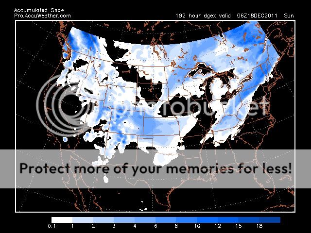
First frame, above freezing with the main slug of moisture.

3 hours later with the cold air crashing. That light precip in West Tennessee has likely mostly already fallen by the time the 32 line has passed.

John1122- Winter Specialist
- Posts : 885
Join date : 2011-12-06
Location : Campbell Co
Re: Winter 2011/2012 Pattern Discussion
![]() by John1122 2011-12-10, 2:18 am
by John1122 2011-12-10, 2:18 am
I figure it will be back to torching by 12z tomorrow. I swear it goes from temps in the 60s to temps in the 30s almost from run to run the past several days.
John1122- Winter Specialist
- Posts : 885
Join date : 2011-12-06
Location : Campbell Co
Re: Winter 2011/2012 Pattern Discussion
![]() by Toot 2011-12-10, 9:27 am
by Toot 2011-12-10, 9:27 am
John1122 wrote:It is back to crashing the cold air in and keeping it there for several days with possible light upslope snow showers in East Tennessee in the wake of these storms.
I figure it will be back to torching by 12z tomorrow. I swear it goes from temps in the 60s to temps in the 30s almost from run to run the past several days.
After the lakes cutter system...the ridge slides off the eastern coast and sets up a very similar situation to that of the last... were a wave of low pressure could form on a quasi-stationary frontal system with access to colder air. This is how i'm expecting it play out anyways.
Toot- La Vida Loca
- Posts : 6644
Join date : 2011-12-05
Location : Cocke County, TN -
Re: Winter 2011/2012 Pattern Discussion
![]() by Stovepipe 2011-12-10, 9:36 am
by Stovepipe 2011-12-10, 9:36 am
Stovepipe- Founding Member
- Posts : 4148
Join date : 2011-12-05
Age : 48
Location : Knoxville, TN -
Re: Winter 2011/2012 Pattern Discussion
![]() by tennessee storm09 2011-12-10, 1:14 pm
by tennessee storm09 2011-12-10, 1:14 pm
tennessee storm09- Severe Wx Specialist
- Posts : 1304
Join date : 2011-12-05
Age : 61
Location : jackson,tennessee(home of 3 ef4 tornadoes since 1999)
Re: Winter 2011/2012 Pattern Discussion
![]() by Toot 2011-12-10, 1:28 pm
by Toot 2011-12-10, 1:28 pm
tennessee storm09 wrote: the se ridge is really flexing its muscles now...
Lol..um Bruce there is a troff over the eastern US.

Toot- La Vida Loca
- Posts : 6644
Join date : 2011-12-05
Location : Cocke County, TN -
Re: Winter 2011/2012 Pattern Discussion
![]() by tennessee storm09 2011-12-10, 1:38 pm
by tennessee storm09 2011-12-10, 1:38 pm
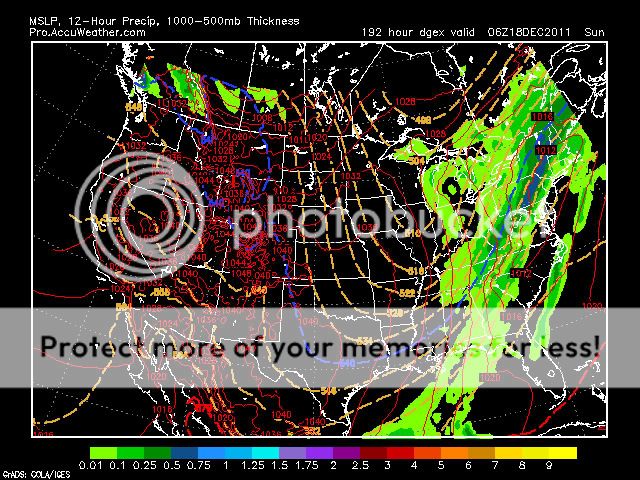
going to have to debate with you on that toot... look at the 500mb chart. you can clearly see the trough west... look at hours 192 to almost 26o something... that way fronts getting hung, cause of the ridge in the se.Cyclonicjunkie wrote:tennessee storm09 wrote: the se ridge is really flexing its muscles now...
Lol..um Bruce there is a troff over the eastern US.
tennessee storm09- Severe Wx Specialist
- Posts : 1304
Join date : 2011-12-05
Age : 61
Location : jackson,tennessee(home of 3 ef4 tornadoes since 1999)
Re: Winter 2011/2012 Pattern Discussion
![]() by Toot 2011-12-10, 1:53 pm
by Toot 2011-12-10, 1:53 pm
tennessee storm09 wrote:going to have to debate with you on that toot... look at the 500mb chart. you can clearly see the trough west...
There is really no debate to it... there is no SE ridge currently...there is a troff over the eastern us and ridge in the west

Toot- La Vida Loca
- Posts : 6644
Join date : 2011-12-05
Location : Cocke County, TN -
Re: Winter 2011/2012 Pattern Discussion
![]() by tennessee storm09 2011-12-10, 1:57 pm
by tennessee storm09 2011-12-10, 1:57 pm
that pic there looks totaly opposite for what i am looking at toot, i am confused.Cyclonicjunkie wrote:tennessee storm09 wrote:going to have to debate with you on that toot... look at the 500mb chart. you can clearly see the trough west...
There is really no debate to it... there is no SE ridge currently...there is a troff ver the eastern us and ridge in the west
tennessee storm09- Severe Wx Specialist
- Posts : 1304
Join date : 2011-12-05
Age : 61
Location : jackson,tennessee(home of 3 ef4 tornadoes since 1999)
Re: Winter 2011/2012 Pattern Discussion
![]() by Toot 2011-12-10, 2:02 pm
by Toot 2011-12-10, 2:02 pm
tennessee storm09 wrote:that pic there looks totaly opposite for what i am looking at toot, i am confused.
That is a 500mb analyisis of the current pattern...now im confused... are you talking about what the 12zgfs shows in day 10 or the current pattern?
Toot- La Vida Loca
- Posts : 6644
Join date : 2011-12-05
Location : Cocke County, TN -
Re: Winter 2011/2012 Pattern Discussion
![]() by tennessee storm09 2011-12-10, 2:10 pm
by tennessee storm09 2011-12-10, 2:10 pm
yeah toot, sorry, i was talking about 10 days out or just beyond. i should made myself clearier... i need an adult beverage buddy. lolCyclonicjunkie wrote:tennessee storm09 wrote:that pic there looks totaly opposite for what i am looking at toot, i am confused.
That is a 500mb analyisis of the current pattern...now im confused... are you talking about what the 12zgfs shows in day 10 or the current pattern?
tennessee storm09- Severe Wx Specialist
- Posts : 1304
Join date : 2011-12-05
Age : 61
Location : jackson,tennessee(home of 3 ef4 tornadoes since 1999)
Re: Winter 2011/2012 Pattern Discussion
![]() by Toot 2011-12-10, 2:12 pm
by Toot 2011-12-10, 2:12 pm
tennessee storm09 wrote: yeah toot, sorry, i was talking about 10 days out or just beyond. i should made myself clearier... i need an adult beverage buddy. lol
lol...I think we could both use one sorry for the misunderstanding
Toot- La Vida Loca
- Posts : 6644
Join date : 2011-12-05
Location : Cocke County, TN -
Page 2 of 37 • 1, 2, 3 ... 19 ... 37 ![]()
» Is winter over? Very weird pattern going on!!
» Winter wx Discussion 2015/16
» Winter Wx Discussion 2013/14
» Winter Wx Discussion 2014/2015


