


**Big Dog ULL/Southern Slider Jan 17th -18th 2013**
Page 8 of 25 •  1 ... 5 ... 7, 8, 9 ... 16 ... 25
 ![]()
Re: **Big Dog ULL/Southern Slider Jan 17th -18th 2013**
![]() by VFL 2013-01-15, 9:35 pm
by VFL 2013-01-15, 9:35 pm
Reb wrote:I like where I am with this system
I don't know why I laughed but I did.

VFL- Member
- Posts : 367
Join date : 2012-04-10
Age : 49
Location : North Knox County
Re: **Big Dog ULL/Southern Slider Jan 17th -18th 2013**
![]() by Toot 2013-01-15, 9:59 pm
by Toot 2013-01-15, 9:59 pm
pippinm wrote:how does this look for the Bristol area?
If the NAM is correct you will be in a winter wonderland come Thursday night.
The 0z models have began running

Man...the NAM is not backing down. MRX wont be able to ignore it much longer


Toot- La Vida Loca
- Posts : 6644
Join date : 2011-12-05
Location : Cocke County, TN -

pippinm- Member
- Posts : 8
Join date : 2013-01-08
Re: **Big Dog ULL/Southern Slider Jan 17th -18th 2013**
![]() by Jed33 2013-01-15, 10:12 pm
by Jed33 2013-01-15, 10:12 pm
Jed33- Admin
- Posts : 930
Join date : 2011-12-09
Location : Morristown, TN
Re: **Big Dog ULL/Southern Slider Jan 17th -18th 2013**
![]() by Toot 2013-01-15, 10:33 pm
by Toot 2013-01-15, 10:33 pm
Ive got the itch..but think I will hold off til tomorrow eveningJed33 wrote:Got an itch yet to do a call map Toot?

Toot- La Vida Loca
- Posts : 6644
Join date : 2011-12-05
Location : Cocke County, TN -
Re: **Big Dog ULL/Southern Slider Jan 17th -18th 2013**
![]() by joereb1 2013-01-15, 10:57 pm
by joereb1 2013-01-15, 10:57 pm

joereb1- Banned
- Posts : 76
Join date : 2011-12-06
Location : Corryton, TN.
Re: **Big Dog ULL/Southern Slider Jan 17th -18th 2013**
![]() by Jed33 2013-01-15, 11:04 pm
by Jed33 2013-01-15, 11:04 pm
Jed33- Admin
- Posts : 930
Join date : 2011-12-09
Location : Morristown, TN

Toot- La Vida Loca
- Posts : 6644
Join date : 2011-12-05
Location : Cocke County, TN -
Re: **Big Dog ULL/Southern Slider Jan 17th -18th 2013**
![]() by tom23 2013-01-15, 11:23 pm
by tom23 2013-01-15, 11:23 pm
tom23- Founding Member
- Posts : 298
Join date : 2012-07-06
Age : 31
Location : Jefferson City, TN
Re: **Big Dog ULL/Southern Slider Jan 17th -18th 2013**
![]() by Toot 2013-01-15, 11:27 pm
by Toot 2013-01-15, 11:27 pm

I imagine it would look similar to this but what do I know..lol

Toot- La Vida Loca
- Posts : 6644
Join date : 2011-12-05
Location : Cocke County, TN -
Re: **Big Dog ULL/Southern Slider Jan 17th -18th 2013**
![]() by tom23 2013-01-15, 11:30 pm
by tom23 2013-01-15, 11:30 pm
tom23- Founding Member
- Posts : 298
Join date : 2012-07-06
Age : 31
Location : Jefferson City, TN
Re: **Big Dog ULL/Southern Slider Jan 17th -18th 2013**
![]() by Jed33 2013-01-15, 11:31 pm
by Jed33 2013-01-15, 11:31 pm
Jed33- Admin
- Posts : 930
Join date : 2011-12-09
Location : Morristown, TN
Re: **Big Dog ULL/Southern Slider Jan 17th -18th 2013**
![]() by tom23 2013-01-15, 11:35 pm
by tom23 2013-01-15, 11:35 pm
Jed33 wrote:Lol, the 12z euro was like the NAM for the most part. It was drier, but had the same track. Not really much more to do but wait and see. If you want to pick a reason for lower accumulation, or for problems look at the amount of rain we are getting. The totally saturated ground could hinder accums. However, according to the data, some serious rates could come down. So, that may help some with the water, lol.
Yeah! There we go! Too much saturation in the ground for snow to lay... forget that mixed precip tale...
Guys/Gals, we won't get any snow accums because of the over-saturation of the ground. NOTHING to see here...
tom23- Founding Member
- Posts : 298
Join date : 2012-07-06
Age : 31
Location : Jefferson City, TN

emcf30- Member
- Posts : 5
Join date : 2013-01-11
Re: **Big Dog ULL/Southern Slider Jan 17th -18th 2013**
![]() by snowdog 2013-01-15, 11:53 pm
by snowdog 2013-01-15, 11:53 pm
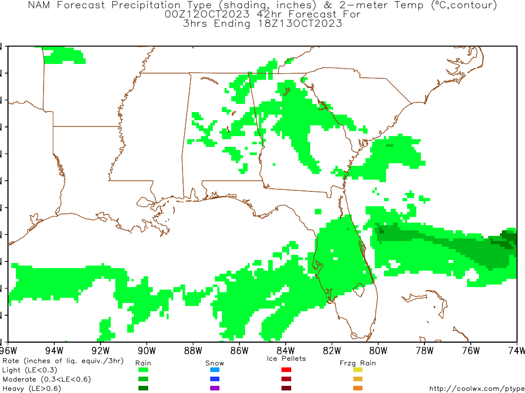
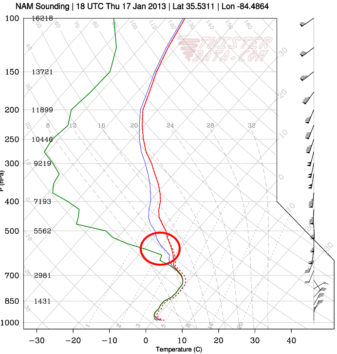
This sounding is from near Athens, TN at hour 42. This is the 1st sounding that comes close to being a snow sounding. All the other soundings were rain (too warm). This sounding is at the time the main precip is moving out. As you can see (circled in red) the snow growth region does not look good and the surface layer is still marginal.
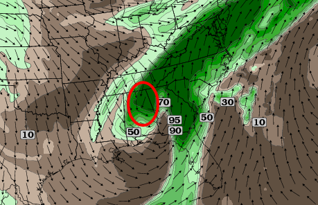
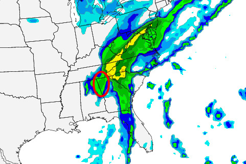
Usually in a ULL type situation the heavy snow band sets up to the west/northwest of the surface low. This is referred to as a trowal. It is clearly seen in the 700mb layer as well as the surface precip layer. Both circled in red. There would probably be heavier precip than what is being shown in this area. I think this is where some light snow accums could be seen. If you scroll through the hours you can see this feature stretch from central MS through northern Ga.
700mb at hour 42
Composite reflectivity at hour 42
I don't think this will be a dynamic enough system to sufficiently cool most locales that do not have a decent bit of elevation (in eastern TN). Areas closer to the Ga. border have a better chance at seeing some snow as they are closer to the ULL and the trowal setup.
:edit: I should add the disclaimer that this isn't my thoughts on this system in general but just my take on the 00z Nam model run and what would occur if it where to play out as modeled.
snowdog- Winter Specialist
- Posts : 855
Join date : 2011-12-14
Age : 46
Location : Mount Juliet, TN
Re: **Big Dog ULL/Southern Slider Jan 17th -18th 2013**
![]() by Toot 2013-01-16, 12:17 am
by Toot 2013-01-16, 12:17 am
If it plays out as its modeled by the NAM.. east TN will get dumped on as shown by the NAM model..lolsnowdog wrote: just my take on the 00z Nam model run and what would occur if it where to play out as modeled.
I disagree about precip moving out at hr 42 and I also disagree with you on this relying on dynamic cooling for a changeover. This is not dependant on the cold core of the ULL as seen on guidance. The same airmass that is allowing frozen precip westward right now will be moving eastward as the trough axis slides eastward. Also.. if you move your mouse northward over at twisterdata the snow growth zone looks much better on their skew t.
Toot- La Vida Loca
- Posts : 6644
Join date : 2011-12-05
Location : Cocke County, TN -
Re: **Big Dog ULL/Southern Slider Jan 17th -18th 2013**
![]() by Neals 2013-01-16, 12:24 am
by Neals 2013-01-16, 12:24 am
Neals- Member
- Posts : 233
Join date : 2012-10-28
Location : Cocke
Re: **Big Dog ULL/Southern Slider Jan 17th -18th 2013**
![]() by snowdog 2013-01-16, 12:36 am
by snowdog 2013-01-16, 12:36 am
Toot wrote:This is not dependant on the cold core of the ULL as seen on guidance. The same airmass that is allowing frozen precip westward right now will be moving eastward as the trough axis slides eastward.
Here is the skew-t from Knoxville as the main precip starts to get cranking. There is a large column of warmth to overcome and it isn't overcome until just before the precip moves out. This is shown to be true on the Hi-Res NAM precip type on ewall.
I disagree about precip moving out at hr 42
In my last post you can see the composite reflectivity at hour 42. The main precip is leaving Knoxville.
snowdog- Winter Specialist
- Posts : 855
Join date : 2011-12-14
Age : 46
Location : Mount Juliet, TN
Re: **Big Dog ULL/Southern Slider Jan 17th -18th 2013**
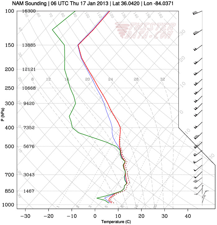
![]() by Toot 2013-01-16, 12:42 am
by Toot 2013-01-16, 12:42 am

Here is the sounding for around the Morristown/Greenville area

Snow all day long!

Toot- La Vida Loca
- Posts : 6644
Join date : 2011-12-05
Location : Cocke County, TN -
Re: **Big Dog ULL/Southern Slider Jan 17th -18th 2013**
![]() by snowdog 2013-01-16, 12:44 am
by snowdog 2013-01-16, 12:44 am
Toot wrote:Here is the sounding for around the Morristown Greenville area
Yeah, I alluded to those areas that have some elevation would do better.
snowdog- Winter Specialist
- Posts : 855
Join date : 2011-12-14
Age : 46
Location : Mount Juliet, TN
Re: **Big Dog ULL/Southern Slider Jan 17th -18th 2013**
![]() by Toot 2013-01-16, 12:45 am
by Toot 2013-01-16, 12:45 am
Toot- La Vida Loca
- Posts : 6644
Join date : 2011-12-05
Location : Cocke County, TN -
Re: **Big Dog ULL/Southern Slider Jan 17th -18th 2013**
![]() by snowdog 2013-01-16, 12:48 am
by snowdog 2013-01-16, 12:48 am
Toot wrote:It looks like Knoxville will be on western edge of things to start with.
If Knoxville is on the western edge then this isn't an eastern TN snowfall but more of a mountain event because you can't go too much further east from Knoxville before you start getting into a good bit of elevation.
snowdog- Winter Specialist
- Posts : 855
Join date : 2011-12-14
Age : 46
Location : Mount Juliet, TN
Re: **Big Dog ULL/Southern Slider Jan 17th -18th 2013**
![]() by snowdog 2013-01-16, 12:50 am
by snowdog 2013-01-16, 12:50 am
Toot wrote:In east TN Morristown and Greeneville are not really considered elevated. Im sure there will be spots that miss out but the NAM and now the GFS show a pretty good thumping over a good chunk of east TN. Its hard to deny that now.
Looking at the location of the skew-t you provided, they are elevated.
snowdog- Winter Specialist
- Posts : 855
Join date : 2011-12-14
Age : 46
Location : Mount Juliet, TN
Re: **Big Dog ULL/Southern Slider Jan 17th -18th 2013**
![]() by Toot 2013-01-16, 12:51 am
by Toot 2013-01-16, 12:51 am
Lol..there is alot of land in between Knoxville and the mountains..believe me ive lived here all my life!snowdog wrote:
If Knoxville is on the western edge then this isn't an eastern TN snowfall but more of a mountain event because you can't go too much further east from Knoxville before you start getting into a good bit of elevation.
Meanwhile guess who joined the party?
The 0z CMC

Toot- La Vida Loca
- Posts : 6644
Join date : 2011-12-05
Location : Cocke County, TN -
Re: **Big Dog ULL/Southern Slider Jan 17th -18th 2013**
![]() by snowdog 2013-01-16, 12:51 am
by snowdog 2013-01-16, 12:51 am
snowdog- Winter Specialist
- Posts : 855
Join date : 2011-12-14
Age : 46
Location : Mount Juliet, TN
Page 8 of 25 • 1 ... 5 ... 7, 8, 9 ... 16 ... 25 ![]()
» Big storm system 16th-18th
» Winter Storm Threat 16th-18th
» January 17th
» April 14th-17th Strong Storm System


