


Post Christmas Storm
Page 2 of 7 •  1, 2, 3, 4, 5, 6, 7
 ![]()
Re: Post Christmas Storm
![]() by Mrgolf 2012-12-21, 4:15 pm
by Mrgolf 2012-12-21, 4:15 pm
Mrgolf- Founding Member
- Posts : 53
Join date : 2011-12-06

Reb- Admin
- Posts : 745
Join date : 2011-12-05
Location : Maryville, TN
Re: Post Christmas Storm
![]() by Toot 2012-12-21, 4:34 pm
by Toot 2012-12-21, 4:34 pm
Lol..I hope we both get crushed. I will make another post later after I look at todays guidancesnowdog wrote:Toot you better start reeling that big fish in, its swimming away. 12z GFS says....shake the magic 8 ball....WEST.

Nice post Jimmy..I agree with most of what you say here. But I think there is still a pretty large cone of uncertainty where this one could possibly track. I believe the lead shortwave that will be responsible for the digging front/trough will be off the California coast Saturday where it then will be sampled by our balloon network. We will probably have a much better idea of where this one may end up tracking when that happens. Glad you have joined here..your knowledge will be greatly appreciated!1234snow wrote:Well after much indecision between the models (especially the GFS) it seems like now the most probable solution is for the 500mb low to close off west of the Mississippi River or very close to it and then track through TN and up close to the KY/WV border before the surface low transfers to the coast. That normally doesn't bode well for much of East Tennessee. I believe it will be very hard to get any accumulating snowfall east of Nashville with this scenario. The dryslot and warm air advection will be a huge problem in eastern TN as the low wraps up while the deformation band rages on out to the west.
The trough is simply not digging enough as it was modeled a few days ago. The ridge out in the Rockies is much flatter than progged a few days ago. The closed low/trough off the Pacific coast is crushing that ridge and flattening it out. Our post Christmas trough was progged to dig all the way to the Mexican border and now it seems like it won't dig any further south than Dallas. But the flattening of the ridge and the confluence in Eastern Canada should keep our shortwave moving eastward even as it cuts off. So, I believe the Great Lakes solution is strongly off the table.
Even though this will be a good size storm, it just looks less impressive than it did a few days ago. This includes the rain part of the storm, even now it doesn't look like as much moisture can be dragged up from the Gulf as before, but still alot of moisture.
Sorry my first post was negative. I believe someone will get clocked out in Western Tennessee as the closed low passes to the east as the deform band swings from southwest to northeast. The confluence in the Northeast needs to hang on for dear life and hopefully it can stay put in place. The lead shortwave/clipper that rolls through Christmas Eve should play a big role in that. If that happens then there is a better chance that our trough can head further east. Where the low closes off will also play a big role as well.
Even if this storm doesn't work out for most or all of us, it definately has a shot at helping us with any energy that may come through around New Years. With most pattern changes it can be a step down process.
Lol..this is not like them at all but I have noticed they are not as conservative as they used to be in their AFD's this winter. They must have a new guy writing forecast discussionsSnowflake wrote:Hazardous Weather Outlook
HAZARDOUS WEATHER OUTLOOK
NATIONAL WEATHER SERVICE MORRISTOWN TN
305 PM EST FRI DEC 21 2012
SIGNIFICANT SNOWFALL IS POSSIBLE LATE WEDNESDAY
THROUGH THURSDAY NIGHT ACROSS EAST TENNESSEE... SOUTHWEST VIRGINIA
AND EXTREME SOUTHWEST NORTH CAROLINA...ESPECIALLY ACROSS THE
HIGHER ELEVATIONS.

Last edited by Toot on 2012-12-21, 4:36 pm; edited 1 time in total

Toot- La Vida Loca
- Posts : 6644
Join date : 2011-12-05
Location : Cocke County, TN -

Re: Post Christmas Storm
![]() by Reb 2012-12-21, 4:36 pm
by Reb 2012-12-21, 4:36 pm

Reb- Admin
- Posts : 745
Join date : 2011-12-05
Location : Maryville, TN
Re: Post Christmas Storm
![]() by Clarksville Snowman 2012-12-21, 5:10 pm
by Clarksville Snowman 2012-12-21, 5:10 pm


Clarksville Snowman- Member
- Posts : 35
Join date : 2012-12-14
Re: Post Christmas Storm
![]() by Toot 2012-12-21, 5:22 pm
by Toot 2012-12-21, 5:22 pm

Toot- La Vida Loca
- Posts : 6644
Join date : 2011-12-05
Location : Cocke County, TN -
Re: Post Christmas Storm
![]() by Toot 2012-12-21, 5:29 pm
by Toot 2012-12-21, 5:29 pm
I think this is close to the eventual track of this storm system
But we wont have better data to work with until the SW in question gets sampled saturday
Toot- La Vida Loca
- Posts : 6644
Join date : 2011-12-05
Location : Cocke County, TN -
Re: Post Christmas Storm
![]() by 1234snow 2012-12-21, 5:33 pm
by 1234snow 2012-12-21, 5:33 pm
Reb wrote:wow MRX biting big time
That is very unusual coming from them! Are you sure they wrote that?
Like yesterday's 18z GFS, today's run keeps the wave open and the surface low scoots off to the northeast on the eastern side of the mountains. Looks like middle TN is the best spot on this run, even with the low off to the east there is still a pesky warm noise across East TN, but it looks like even we can turn to snow at the end. There is alot less QPF on this run aswell. So the 18z GFS is with the CMC camp.
It seems like the 6z and 18z runs of the GFS like to keep the wave open longer while the 0z and 12z runs are more amplified. With that in mind I expect the 0z GFS to have at least a slightly more amplified solution.
1234snow- Winter Specialist
- Posts : 24
Join date : 2012-12-21
Age : 31
Location : Gate City, VA
Re: Post Christmas Storm
![]() by andyhb 2012-12-21, 7:33 pm
by andyhb 2012-12-21, 7:33 pm
FYPToot wrote:And just as I post that graphic the 18z GFS comes much further east..just to the right of the 12z euro and east of the Apps.
Ithinkhope this is close to the eventual track of this storm system
But we wont have better data to work with until the SW in question gets sampled saturday

andyhb- Severe Wx Specialist
- Posts : 84
Join date : 2012-03-26
Re: Post Christmas Storm
![]() by Toot 2012-12-21, 7:54 pm
by Toot 2012-12-21, 7:54 pm
andyhb wrote:
FYP
LOL..why would I try to "hope" that track into existence? That's not even scientifically possible!
Not to mention its not an ideal track for snow in east TN.. even though it would eventually change to snow but then again so would the 12z euro
For a whopper here in east TN I need the surface low to track closer to the CMC.. just a hundred miles inland. The track I have in mind is just a hundred miles or so east across the Appalachians from the 12z Euro..so its not that much different in outcome here. Ive watched many gulf lows during winter in the past decade and I have only seen a few that cut west of the Apps. Gulf cyclogenesis = east of the Apps stormtrack most of the time during winter..its a physics thing but there are exceptions..dont get me wrong.
Toot- La Vida Loca
- Posts : 6644
Join date : 2011-12-05
Location : Cocke County, TN -
Re: Post Christmas Storm
![]() by tennessee storm09 2012-12-21, 10:42 pm
by tennessee storm09 2012-12-21, 10:42 pm
tennessee storm09- Severe Wx Specialist
- Posts : 1304
Join date : 2011-12-05
Age : 61
Location : jackson,tennessee(home of 3 ef4 tornadoes since 1999)
Re: Post Christmas Storm
![]() by Reb 2012-12-21, 10:52 pm
by Reb 2012-12-21, 10:52 pm
possible as a name? did i read this post correctly? wtftennessee storm09 wrote:hearing that TWC will be naming this storm possible... what crazy names they r using...

Reb- Admin
- Posts : 745
Join date : 2011-12-05
Location : Maryville, TN
Re: Post Christmas Storm
![]() by tennessee storm09 2012-12-21, 10:54 pm
by tennessee storm09 2012-12-21, 10:54 pm
yeah reb, what to say the name will be euclid, something like that. lolReb wrote:possible as a name? did i read this post correctly? wtftennessee storm09 wrote:hearing that TWC will be naming this storm possible... what crazy names they r using...
tennessee storm09- Severe Wx Specialist
- Posts : 1304
Join date : 2011-12-05
Age : 61
Location : jackson,tennessee(home of 3 ef4 tornadoes since 1999)
Re: Post Christmas Storm
![]() by Reb 2012-12-21, 11:11 pm
by Reb 2012-12-21, 11:11 pm
Reb- Admin
- Posts : 745
Join date : 2011-12-05
Location : Maryville, TN
Re: Post Christmas Storm
![]() by skillsweather 2012-12-21, 11:24 pm
by skillsweather 2012-12-21, 11:24 pm
skillsweather- Banned
- Posts : 313
Join date : 2011-12-06
Age : 32
Location : tennessee Wilson county Ne Corner
Re: Post Christmas Storm
![]() by Toot 2012-12-22, 12:11 am
by Toot 2012-12-22, 12:11 am
skillsweather wrote:East Tennessee probably misses out on the snow part of this. Heck even most of Middle Tennessee does on this run. Hope it is a fluke.
I wouldnt be calling this anyone's storm yet. We're still around a hundred hrs out and havent even got into the NAM's range yet. A couple of hundred miles shift west or east will make a big difference in who sees what. It could easily shift to a completely coastal system that leaves the whole state high and dry! Given the guidance data the past few days I think middle TN will be the big winners on this but that's just my opinion until we get some sampled data.
0z Canadian holds firm with the more east track

Last edited by Toot on 2012-12-22, 12:16 am; edited 1 time in total
Toot- La Vida Loca
- Posts : 6644
Join date : 2011-12-05
Location : Cocke County, TN -
Re: Post Christmas Storm
![]() by tennessee storm09 2012-12-22, 12:15 am
by tennessee storm09 2012-12-22, 12:15 am
tennessee storm09- Severe Wx Specialist
- Posts : 1304
Join date : 2011-12-05
Age : 61
Location : jackson,tennessee(home of 3 ef4 tornadoes since 1999)
Re: Post Christmas Storm
![]() by snowdog 2012-12-22, 12:38 am
by snowdog 2012-12-22, 12:38 am
snowdog- Winter Specialist
- Posts : 855
Join date : 2011-12-14
Age : 46
Location : Mount Juliet, TN
Re: Post Christmas Storm
![]() by Reb 2012-12-22, 1:18 am
by Reb 2012-12-22, 1:18 am
Reb- Admin
- Posts : 745
Join date : 2011-12-05
Location : Maryville, TN
Re: Post Christmas Storm
![]() by snowdog 2012-12-22, 10:24 am
by snowdog 2012-12-22, 10:24 am
I dont know how that track will work out for Nashville. I think a few days ago the models were overestimating the amount of cold air being brought down. It seems model runs the last couple of days haven't been as cold.
snowdog- Winter Specialist
- Posts : 855
Join date : 2011-12-14
Age : 46
Location : Mount Juliet, TN
Re: Post Christmas Storm
![]() by Adam2014 2012-12-22, 10:54 am
by Adam2014 2012-12-22, 10:54 am

Adam2014- Founding Member
- Posts : 1424
Join date : 2011-12-05
Age : 28
Location : Lawrenceburg,TN
Re: Post Christmas Storm
![]() by Adam2014 2012-12-22, 10:55 am
by Adam2014 2012-12-22, 10:55 am
Adam2014- Founding Member
- Posts : 1424
Join date : 2011-12-05
Age : 28
Location : Lawrenceburg,TN
Re: Post Christmas Storm
![]() by Adam2014 2012-12-22, 10:55 am
by Adam2014 2012-12-22, 10:55 am
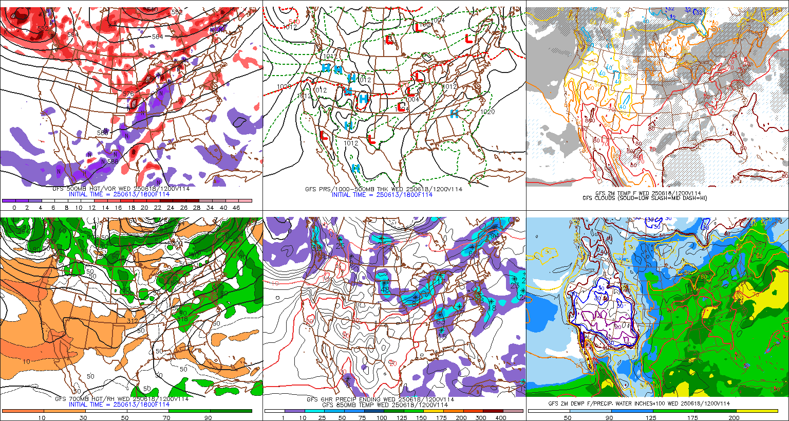
This is the 2nd run of the GFS today. This is the American model..... The blue line is the rain and snow line. The Darker shade of green you have is the heaiver moisture. The Big L is the low pressure system. This is still a little far West and the low tracks just West of Lawrenceburg. The area recieves snow though, and around 2-3 inches of snow. People around this area would be happy with this solution. It could be better, because areas to the Northwest of here could see 6-8 inches. Beggers cannot be choosers though!
[img]
 [/img]
Adam2014- Founding Member
- Posts : 1424
Join date : 2011-12-05
Age : 28
Location : Lawrenceburg,TN
Re: Post Christmas Storm
![]() by Clarksville Snowman 2012-12-22, 11:13 am
by Clarksville Snowman 2012-12-22, 11:13 am
Clarksville Snowman- Member
- Posts : 35
Join date : 2012-12-14
Re: Post Christmas Storm
![]() by Toot 2012-12-22, 12:12 pm
by Toot 2012-12-22, 12:12 pm

I might recieve some flack for this because it goes against what trusted guidance says but I Just dont buy the crazy things the operational Euro/GFS are doing. I beleive a major nor'easter will affect most of the eastern US but im not buying the low riding up the TN valley and then magically transferring to the east coast..lol that is preposterous and very unlikely IMO!!
I do believe when the energy for this system gets sampled off the west coast by the balloon network that you will see the secondary low completely disappear as a more gradual phase takes place! I see no scientific reason that this wont be a classic Nor'easter via Miller A cyclogenesis. Could I be wrong? Totally could be.. but sensible synoptics and climatology will argue for the track I have below. Even if my forecast dont verify its still going to be a major storm system for some portion of TN.

It should be noted that this will begin as rain in the white area south of the blue area
Toot- La Vida Loca
- Posts : 6644
Join date : 2011-12-05
Location : Cocke County, TN -
Page 2 of 7 • 1, 2, 3, 4, 5, 6, 7 ![]()
» White Christmas 2012
» BIG DOG winter storm JAN 22-24
» White Christmas Chances higher than normal this year
» March 5-6th Winter Storm


