


Spring wx discussion 2013 edition
Page 10 of 12 •  1, 2, 3 ... 9, 10, 11, 12
 ![]()
Re: Spring wx discussion 2013 edition
![]() by Jed33 2013-05-14, 10:07 pm
by Jed33 2013-05-14, 10:07 pm
Jed33- Admin
- Posts : 930
Join date : 2011-12-09
Location : Morristown, TN
Re: Spring wx discussion 2013 edition
![]() by VFL 2013-05-14, 10:13 pm
by VFL 2013-05-14, 10:13 pm
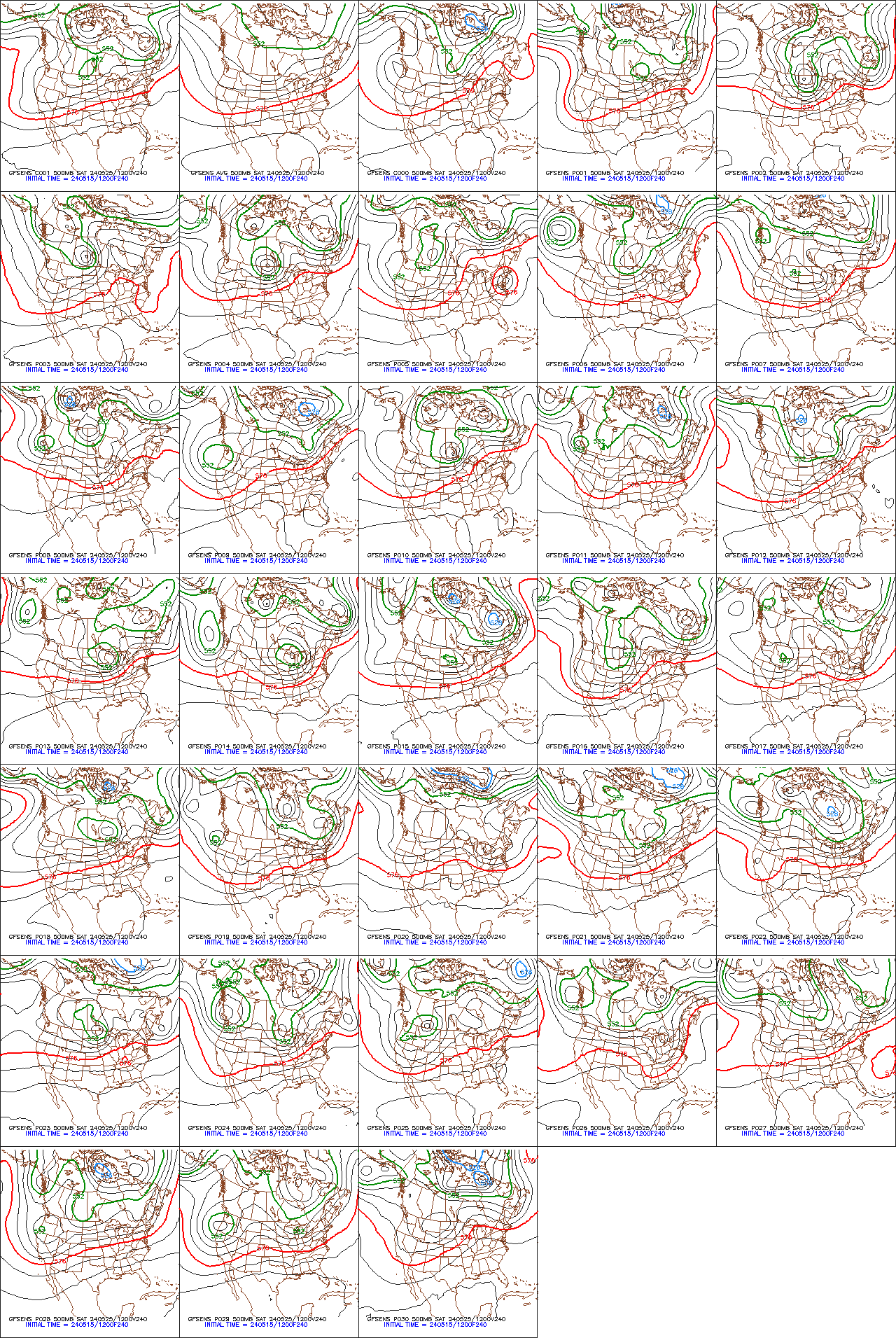
Toot wrote:Mid level ridge of high pressure becoming pretty impressive in northern Atlantic. Feature is currently dominating the longwave weather pattern!

How does this effect our weather now and down the road?

VFL- Member
- Posts : 367
Join date : 2012-04-10
Age : 49
Location : North Knox County
Re: Spring wx discussion 2013 edition
![]() by Toot 2013-05-14, 10:52 pm
by Toot 2013-05-14, 10:52 pm
Its subtropical in nature and needs to be watched as to how it evolves and to where it moves. Death ridges will become an issue at our latitude over the next couple of months and where they setup will likely be key to a warmer or cooler than normal summer. This impressive high pressure system is currently causing a persistent trough off the east coast which is allowing another ridge to build in over our area. This will cause warm to even hot weather as long as the massive ridge stays put in this position there in the north atlantic! Where its located and how its orientated will likley have major implications on our weather pattern for the next several weeks.VFL wrote:
How does this effect our weather now and down the road?

Toot- La Vida Loca
- Posts : 6644
Join date : 2011-12-05
Location : Cocke County, TN -

Re: Spring wx discussion 2013 edition
![]() by Toot 2013-05-15, 5:18 pm
by Toot 2013-05-15, 5:18 pm
If the cutoff low dont happen you will likely see me posting this in the near future..lol!
Toot- La Vida Loca
- Posts : 6644
Join date : 2011-12-05
Location : Cocke County, TN -
Re: Spring wx discussion 2013 edition
![]() by Dyersburg Weather 2013-05-15, 10:37 pm
by Dyersburg Weather 2013-05-15, 10:37 pm

Dyersburg Weather- Banned
- Posts : 342
Join date : 2011-12-25
Age : 55
Location : Dyersburg , TN
Re: Spring wx discussion 2013 edition
![]() by Toot 2013-05-15, 11:04 pm
by Toot 2013-05-15, 11:04 pm
Left turner!!Dyersburg Weather wrote:Massive mile wide tornado being reported near Cleburne Tx.

Toot- La Vida Loca
- Posts : 6644
Join date : 2011-12-05
Location : Cocke County, TN -
Re: Spring wx discussion 2013 edition
![]() by tennessee storm09 2013-05-15, 11:39 pm
by tennessee storm09 2013-05-15, 11:39 pm
tennessee storm09- Severe Wx Specialist
- Posts : 1304
Join date : 2011-12-05
Age : 61
Location : jackson,tennessee(home of 3 ef4 tornadoes since 1999)
Re: Spring wx discussion 2013 edition
![]() by Toot 2013-05-16, 5:14 pm
by Toot 2013-05-16, 5:14 pm
A look at high temps this coming Tuesday

Toot- La Vida Loca
- Posts : 6644
Join date : 2011-12-05
Location : Cocke County, TN -
Re: Spring wx discussion 2013 edition
![]() by Toot 2013-05-16, 5:35 pm
by Toot 2013-05-16, 5:35 pm

Toot- La Vida Loca
- Posts : 6644
Join date : 2011-12-05
Location : Cocke County, TN -
Re: Spring wx discussion 2013 edition
![]() by Toot 2013-05-16, 7:38 pm
by Toot 2013-05-16, 7:38 pm

Toot- La Vida Loca
- Posts : 6644
Join date : 2011-12-05
Location : Cocke County, TN -
Re: Spring wx discussion 2013 edition
![]() by John1122 2013-05-16, 9:06 pm
by John1122 2013-05-16, 9:06 pm
John1122- Winter Specialist
- Posts : 885
Join date : 2011-12-06
Location : Campbell Co
Re: Spring wx discussion 2013 edition
![]() by windstorm 2013-05-17, 4:02 pm
by windstorm 2013-05-17, 4:02 pm

windstorm- Member
- Posts : 891
Join date : 2012-03-26
Location : Harrison, tn
Re: Spring wx discussion 2013 edition
![]() by Toot 2013-05-17, 5:03 pm
by Toot 2013-05-17, 5:03 pm
Hoping the bulk of it holds off til later tonight..have an outdoor bluegrass festival going on this evening!windstorm wrote:Weak low pressure area over Memphis should move this way overnight with some good rains in SE/E Tenn. They are saying 1.5 or more with heating of the day, today. Severe weather is always possible but with this system should be more on the Isolated side. But keep and eye on the sky just in case. But mostly likely reaching E and NE Tenn late evening and over night.
Toot- La Vida Loca
- Posts : 6644
Join date : 2011-12-05
Location : Cocke County, TN -
Re: Spring wx discussion 2013 edition
![]() by windstorm 2013-05-17, 6:34 pm
by windstorm 2013-05-17, 6:34 pm
windstorm- Member
- Posts : 891
Join date : 2012-03-26
Location : Harrison, tn
Re: Spring wx discussion 2013 edition
![]() by Toot 2013-05-18, 11:18 am
by Toot 2013-05-18, 11:18 am
If you hadnt noticed..the SPC (Storm prediction center) has issued a moderate risk for severe thunderstorms in the plains states as we head towards dark tonight and tomorrow. Tornados are expected due to such favorable atmospheric conditions. Without getting too deep and technical and making things much harder to understand.. below is two ugly looking graphics from the latest run of the 4km nam that will confirm this severe weather threat.
On the left is 0-3km SRH (Storm relative helicity) in simple terms this is a way of measuring the twisting and turning of air from way up high all the way down near the ground and these values are extremely high! You normally get rotating supercell development with values of 3 to 500..here we have values of 6 to 800!!
On the right is CAPE (convective available potential energy) which is basically a measurement of atmospheric instability gathered mostly from temperature differences between two different airmasses whether that be up high or at the surface. Anyways..you normally only need around 2 to 3000j/kg for the fireworks to go off! Here we have values of 5000 or more!! These paramaters are off the charts and are very supportive of significant severe weather out in the plains states tonight and tomorrow.

Toot- La Vida Loca
- Posts : 6644
Join date : 2011-12-05
Location : Cocke County, TN -
Re: Spring wx discussion 2013 edition
![]() by VFL 2013-05-18, 3:45 pm
by VFL 2013-05-18, 3:45 pm
VFL- Member
- Posts : 367
Join date : 2012-04-10
Age : 49
Location : North Knox County
Re: Spring wx discussion 2013 edition
![]() by Toot 2013-05-18, 11:34 pm
by Toot 2013-05-18, 11:34 pm
I used to have to jumble through 100's of bookmarks for different models and paramaters for graphics and it took alot of my time. I would dig through those bookmarks for hours trying to find what I was looking for. Now I just pay for it and its all in one place. As far as model graphics go.. wxbell has the biggest selection of models with the best graphics out there IMO.
Toot- La Vida Loca
- Posts : 6644
Join date : 2011-12-05
Location : Cocke County, TN -
Re: Spring wx discussion 2013 edition
![]() by Toot 2013-05-19, 5:51 pm
by Toot 2013-05-19, 5:51 pm

Toot- La Vida Loca
- Posts : 6644
Join date : 2011-12-05
Location : Cocke County, TN -
Re: Spring wx discussion 2013 edition
![]() by Dyersburg Weather 2013-05-20, 9:18 am
by Dyersburg Weather 2013-05-20, 9:18 am
THE UPPER RIDGE SHOULD TEMPORARILY REBUILD OVER THE MID SOUTH
DURING THE DAY TUESDAY BRINGING A LULL IN ANY CONVECTIVE ACTIVITY
AS THE CAPPING INVERSION STRENGTHENS AND INHIBITS CONVECTIVE
DEVELOPMENT. SKIES SHOULD SCATTER OUT WITH TEMPERATURES RISING
WELL INTO THE 80S BY TUESDAY AFTERNOON ALONG WITH CONTINUED HUMID
CONDITIONS AS DEWPOINTS REMAIN NEAR 70 DEGREES. A THIRD AND
STRONGER SHORTWAVE WILL EJECT FROM THE SOUTHERN PLAINS INTO THE
MID SOUTH BY TUESDAY EVENING. THIS SHORTWAVE SHOULD TAKE ON A
NEGATIVE TILT AS IT PROGRESSES ACROSS THE MID SOUTH TUESDAY NIGHT
INTO WEDNESDAY MORNING. AS THIS OCCURS...THE CAPPING INVERSION
WILL BEGIN TO ERODE ALLOWING FOR NUMEROUS THUNDERSTORMS TO DEVELOP
OVER WESTERN SECTIONS OF THE MID SOUTH LATE TUESDAY AFTERNOON.
THUNDERSTORMS SHOULD QUICKLY SPREAD NORTHEAST ACROSS THE REGION
TUESDAY NIGHT INTO WEDNESDAY MORNING. THE ATMOSPHERE SHOULD REMAIN
MODERATELY UNSTABLE THROUGH TUESDAY NIGHT WITH SBCAPE VALUES
RANGING FROM 1500-2500 J/KG...LI/S -6C TO -10C...AND MID LEVEL
LAPSE RATES GREATER THAN 7.0 C/KM. IN ADDITION...DEEP LAYER SHEAR
SHOULD STRENGTHEN AHEAD OF THE SHORTWAVE AS A 40-50 KT LOW LEVEL
JET OVERSPREADS THE AREA ALONG WITH AROUND 50 KTS OF MID LEVEL
FLOW. INITIAL THUNDERSTORM MODE SHOULD BE A MIX OF SUPERCELLS AND
BOWING LINE SEGMENTS EARLY IN THE CONVECTIVE EVOLUTION THROUGH
TUESDAY EVENING...EVENTUALLY TRANSITIONING TO AN EXPANSIVE QUASI-
LINEAR CONVECTIVE SYSTEM (QLCS). THE PRIMARY SEVERE THREATS WILL
BE DAMAGING WINDS AND LARGE HAIL. A TORNADO THREAT WILL EXIST
EARLY IN THE EVENT MAINLY ALONG AND WEST OF THE MISSISSIPPI RIVER
TUESDAY EVENING...ESPECIALLY WITH ANY DISCRETE SUPERCELLS THAT
DEVELOP. ANY TORNADO THREAT SHOULD DIMINISH LATER TUESDAY NIGHT AS
LOW LEVEL FLOW VEERS.
Dyersburg Weather- Banned
- Posts : 342
Join date : 2011-12-25
Age : 55
Location : Dyersburg , TN
Re: Spring wx discussion 2013 edition
![]() by chaser2b 2013-05-20, 4:26 pm
by chaser2b 2013-05-20, 4:26 pm
chaser2b- Member
- Posts : 11
Join date : 2012-04-03
Re: Spring wx discussion 2013 edition
![]() by Toot 2013-05-20, 5:16 pm
by Toot 2013-05-20, 5:16 pm
Man..that was a monster!chaser2b wrote:Moore, Oklahoma is about to be hammered by a possible two-mile wide tornado.

Toot- La Vida Loca
- Posts : 6644
Join date : 2011-12-05
Location : Cocke County, TN -
Re: Spring wx discussion 2013 edition
![]() by Dyersburg Weather 2013-05-20, 5:34 pm
by Dyersburg Weather 2013-05-20, 5:34 pm
Dyersburg Weather- Banned
- Posts : 342
Join date : 2011-12-25
Age : 55
Location : Dyersburg , TN
Re: Spring wx discussion 2013 edition
![]() by Toot 2013-05-20, 7:13 pm
by Toot 2013-05-20, 7:13 pm

Toot- La Vida Loca
- Posts : 6644
Join date : 2011-12-05
Location : Cocke County, TN -
Re: Spring wx discussion 2013 edition
![]() by Toot 2013-05-20, 7:18 pm
by Toot 2013-05-20, 7:18 pm

Toot- La Vida Loca
- Posts : 6644
Join date : 2011-12-05
Location : Cocke County, TN -
Toot- La Vida Loca
- Posts : 6644
Join date : 2011-12-05
Location : Cocke County, TN -
Page 10 of 12 • 1, 2, 3 ... 9, 10, 11, 12 ![]()
» Spring wx discussion 2014
» Spring 2012 weather discussion
» April Observations 2013 edition
» Predict your overnight weather 2013/14 edition


