


Accumulating Snow Possible Mar 24-26
Page 2 of 8 •  1, 2, 3, 4, 5, 6, 7, 8
 ![]()
Re: Accumulating Snow Possible Mar 24-26
![]() by Toot 2013-03-19, 9:30 pm
by Toot 2013-03-19, 9:30 pm
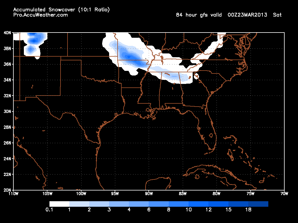
 This snow depth graphic is NOT just what happens at that particular hour!
This poster basically dismissed the whole accumulating snowfall event in west Tennessee due to an hour of time on a sounding that was indicative of a LL warm nose. Models dont paint snow in areas that have low level warm air the algorithim takes low level temps into account

Toot- La Vida Loca
- Posts : 6644
Join date : 2011-12-05
Location : Cocke County, TN -

Re: Accumulating Snow Possible Mar 24-26
![]() by tennessee storm09 2013-03-19, 10:45 pm
by tennessee storm09 2013-03-19, 10:45 pm
tennessee storm09- Severe Wx Specialist
- Posts : 1304
Join date : 2011-12-05
Age : 61
Location : jackson,tennessee(home of 3 ef4 tornadoes since 1999)
Re: Accumulating Snow Possible Mar 24-26
![]() by Jscentraltn 2013-03-19, 10:48 pm
by Jscentraltn 2013-03-19, 10:48 pm


Jscentraltn- Admin
- Posts : 703
Join date : 2013-01-19
Age : 45
Location : Cheatham county
Re: Accumulating Snow Possible Mar 24-26
![]() by Toot 2013-03-19, 10:50 pm
by Toot 2013-03-19, 10:50 pm
12Km NAM

And yes low level temps will support this but the GFS is further south with the stripe of snow
4km HI RES NAM

Toot- La Vida Loca
- Posts : 6644
Join date : 2011-12-05
Location : Cocke County, TN -
Re: Accumulating Snow Possible Mar 24-26
![]() by Jscentraltn 2013-03-19, 10:52 pm
by Jscentraltn 2013-03-19, 10:52 pm

Jscentraltn- Admin
- Posts : 703
Join date : 2013-01-19
Age : 45
Location : Cheatham county
Re: Accumulating Snow Possible Mar 24-26
![]() by tennessee storm09 2013-03-19, 10:55 pm
by tennessee storm09 2013-03-19, 10:55 pm
yep, that wasnt a bad run for west tn toot... i be happy with just seeing some big fat sloppy wet flakes fly around. lolToot wrote:0z NAM for west TN folk
12Km NAM
And yes low level temps will support this but the GFS is further south with the stripe of snow
4km HI RES NAM
tennessee storm09- Severe Wx Specialist
- Posts : 1304
Join date : 2011-12-05
Age : 61
Location : jackson,tennessee(home of 3 ef4 tornadoes since 1999)
Re: Accumulating Snow Possible Mar 24-26
![]() by Toot 2013-03-19, 11:49 pm
by Toot 2013-03-19, 11:49 pm
- Code:
URGENT - WINTER WEATHER MESSAGE
NATIONAL WEATHER SERVICE PADUCAH KY
915 PM CDT TUE MAR 19 2013

.LOW PRESSURE WILL DEVELOP OVER THE TEXAS AND OKLAHOMA PANHANDLE
REGION ON THURSDAY AND THURSDAY NIGHT...ALLOWING MOISTURE TO
OVERRIDE A VERY COLD DOME OF COLD AIR IN PLACE OVER SOUTHEAST
MISSOURI.

MOZ100-107>110-114-201015-
/O.CON.KPAH.WS.A.0001.130321T1800Z-130322T1500Z/
WAYNE MO-CARTER-RIPLEY-BUTLER-STODDARD-NEW MADRID-
INCLUDING THE CITIES OF...PIEDMONT...VAN BUREN...DONIPHAN...
POPLAR BLUFF...BLOOMFIELD...NEW MADRID
915 PM CDT TUE MAR 19 2013

...WINTER STORM WATCH REMAINS IN EFFECT FROM THURSDAY AFTERNOON
THROUGH FRIDAY MORNING...

A WINTER STORM WATCH REMAINS IN EFFECT FROM THURSDAY AFTERNOON
THROUGH FRIDAY MORNING.

* TIMING...IT NOW APPEARS THAT LIGHT SNOW WILL BREAK OUT THURSDAY
  AFTERNOON...ESPECIALLY IN AREAS FROM POPLAR BLUFF WESTWARD INTO
  THE OZARK FOOTHILLS. THE SNOW WILL LIKELY BECOME HEAVY AT TIMES
  AS THE PRECIPITATION SHIFTS SOUTHEAST INTO THE MISSOURI BOOT
  HILL REGION LATE THURSDAY AND THURSDAY EVENING.

* MAIN IMPACT...THE MAIN IMPACT WITH THIS EVENT WILL COME WITH
  LOCALLY HEAVY SNOW AMOUNTS IN THE 3 TO 6 INCH RANGE. HIGHEST
  AMOUNTS WILL LIKELY BE CONFINED TO THE OZARK FOOTHILLS WEST OF
  POPLAR BLUFF.

* OTHER IMPACTS...UNSEASONABLY COLD AIR IN PLACE PRIOR TO THE
  EXPECTED SNOWFALL AND THE FACT THAT THE MUCH OF THE EVENT WILL
  OCCUR DURING THE LATE AFTERNOON AND NIGHT TIME HOURS WILL
  INCREASE THE CHANCES OF DANGEROUS TRAVEL CONDITIONS. MANY
  ROADWAYS COULD QUICKLY BECOME SLICK AND HAZARDOUS.

PRECAUTIONARY/PREPAREDNESS ACTIONS...

A WINTER STORM WATCH MEANS THERE IS A POTENTIAL FOR SIGNIFICANT
SNOW...SLEET...OR ICE ACCUMULATIONS THAT WOULD GREATLY IMPACT
TRAVEL. STAY TUNED FOR LATER STATEMENTS. THIS WATCH WILL BE
UPGRADED TO A WARNING IF WINTER STORM CONDITIONS BECOME MORE
CERTAIN.
Toot- La Vida Loca
- Posts : 6644
Join date : 2011-12-05
Location : Cocke County, TN -

keithinala- Banned
- Posts : 62
Join date : 2011-12-30 -
Re: Accumulating Snow Possible Mar 24-26
![]() by keithinala 2013-03-19, 11:58 pm
by keithinala 2013-03-19, 11:58 pm
Yeah, I'm always amazed at how some are so hostile towards anything showing snow...and it's like that all winter, not just because it's MarchToot wrote:A certain someone continues to downplay the possible snow in parts of west TN but back in realityville the NWS in Paducah has issued Winter storm watches just a hair north of Dyersburg TN for 3-6 inches of heavy wet snow.
- Code:
URGENT - WINTER WEATHER MESSAGE
NATIONAL WEATHER SERVICE PADUCAH KY
915 PM CDT TUE MAR 19 2013

.LOW PRESSURE WILL DEVELOP OVER THE TEXAS AND OKLAHOMA PANHANDLE
REGION ON THURSDAY AND THURSDAY NIGHT...ALLOWING MOISTURE TO
OVERRIDE A VERY COLD DOME OF COLD AIR IN PLACE OVER SOUTHEAST
MISSOURI.

MOZ100-107>110-114-201015-
/O.CON.KPAH.WS.A.0001.130321T1800Z-130322T1500Z/
WAYNE MO-CARTER-RIPLEY-BUTLER-STODDARD-NEW MADRID-
INCLUDING THE CITIES OF...PIEDMONT...VAN BUREN...DONIPHAN...
POPLAR BLUFF...BLOOMFIELD...NEW MADRID
915 PM CDT TUE MAR 19 2013

...WINTER STORM WATCH REMAINS IN EFFECT FROM THURSDAY AFTERNOON
THROUGH FRIDAY MORNING...

A WINTER STORM WATCH REMAINS IN EFFECT FROM THURSDAY AFTERNOON
THROUGH FRIDAY MORNING.

* TIMING...IT NOW APPEARS THAT LIGHT SNOW WILL BREAK OUT THURSDAY
  AFTERNOON...ESPECIALLY IN AREAS FROM POPLAR BLUFF WESTWARD INTO
  THE OZARK FOOTHILLS. THE SNOW WILL LIKELY BECOME HEAVY AT TIMES
  AS THE PRECIPITATION SHIFTS SOUTHEAST INTO THE MISSOURI BOOT
  HILL REGION LATE THURSDAY AND THURSDAY EVENING.

* MAIN IMPACT...THE MAIN IMPACT WITH THIS EVENT WILL COME WITH
  LOCALLY HEAVY SNOW AMOUNTS IN THE 3 TO 6 INCH RANGE. HIGHEST
  AMOUNTS WILL LIKELY BE CONFINED TO THE OZARK FOOTHILLS WEST OF
  POPLAR BLUFF.

* OTHER IMPACTS...UNSEASONABLY COLD AIR IN PLACE PRIOR TO THE
  EXPECTED SNOWFALL AND THE FACT THAT THE MUCH OF THE EVENT WILL
  OCCUR DURING THE LATE AFTERNOON AND NIGHT TIME HOURS WILL
  INCREASE THE CHANCES OF DANGEROUS TRAVEL CONDITIONS. MANY
  ROADWAYS COULD QUICKLY BECOME SLICK AND HAZARDOUS.

PRECAUTIONARY/PREPAREDNESS ACTIONS...

A WINTER STORM WATCH MEANS THERE IS A POTENTIAL FOR SIGNIFICANT
SNOW...SLEET...OR ICE ACCUMULATIONS THAT WOULD GREATLY IMPACT
TRAVEL. STAY TUNED FOR LATER STATEMENTS. THIS WATCH WILL BE
UPGRADED TO A WARNING IF WINTER STORM CONDITIONS BECOME MORE
CERTAIN.
keithinala- Banned
- Posts : 62
Join date : 2011-12-30 -
Re: Accumulating Snow Possible Mar 24-26
![]() by Toot 2013-03-20, 12:01 am
by Toot 2013-03-20, 12:01 am
Exactly Keith..good luck to you on the RPM therekeithinala wrote: Yeah, I'm always amazed at how some are so hostile towards anything showing snow...and it's like that all winter, not just because it's March
Toot- La Vida Loca
- Posts : 6644
Join date : 2011-12-05
Location : Cocke County, TN -
keithinala- Banned
- Posts : 62
Join date : 2011-12-30 -

keithinala- Banned
- Posts : 62
Join date : 2011-12-30 -
Re: Accumulating Snow Possible Mar 24-26
![]() by Jed33 2013-03-20, 6:57 am
by Jed33 2013-03-20, 6:57 am
Jed33- Admin
- Posts : 930
Join date : 2011-12-09
Location : Morristown, TN
Re: Accumulating Snow Possible Mar 24-26
![]() by Toot 2013-03-20, 9:11 am
by Toot 2013-03-20, 9:11 am
Snow depth

Accumulated snowfall

Toot- La Vida Loca
- Posts : 6644
Join date : 2011-12-05
Location : Cocke County, TN -
Re: Accumulating Snow Possible Mar 24-26
![]() by windstorm 2013-03-20, 12:56 pm
by windstorm 2013-03-20, 12:56 pm

windstorm- Member
- Posts : 891
Join date : 2012-03-26
Location : Harrison, tn
Re: Accumulating Snow Possible Mar 24-26
![]() by Toot 2013-03-20, 4:50 pm
by Toot 2013-03-20, 4:50 pm

Toot- La Vida Loca
- Posts : 6644
Join date : 2011-12-05
Location : Cocke County, TN -
Re: Accumulating Snow Possible Mar 24-26
![]() by John1122 2013-03-20, 7:51 pm
by John1122 2013-03-20, 7:51 pm
John1122- Winter Specialist
- Posts : 885
Join date : 2011-12-06
Location : Campbell Co
Re: Accumulating Snow Possible Mar 24-26
![]() by Snowfia 2013-03-20, 7:58 pm
by Snowfia 2013-03-20, 7:58 pm
Snowfia- Member
- Posts : 12
Join date : 2013-01-13
Location : Campbell Co, TN
Re: Accumulating Snow Possible Mar 24-26
![]() by John1122 2013-03-20, 8:31 pm
by John1122 2013-03-20, 8:31 pm
Snowfia wrote:Quiet a change outside from 600pm to 800pm. Wind blowing starting to sleet/snow in Southern Campbell County.
It's been snowing some big flakes up here on the mountain.
John1122- Winter Specialist
- Posts : 885
Join date : 2011-12-06
Location : Campbell Co
Re: Accumulating Snow Possible Mar 24-26
![]() by etnwx 2013-03-20, 8:40 pm
by etnwx 2013-03-20, 8:40 pm

etnwx- Storm Spotter
- Posts : 313
Join date : 2012-10-25
Age : 55
Location : NW Knox County -
Re: Accumulating Snow Possible Mar 24-26
![]() by Jed33 2013-03-20, 8:54 pm
by Jed33 2013-03-20, 8:54 pm
Jed33- Admin
- Posts : 930
Join date : 2011-12-09
Location : Morristown, TN
Re: Accumulating Snow Possible Mar 24-26
![]() by Snowfia 2013-03-20, 9:22 pm
by Snowfia 2013-03-20, 9:22 pm
Snowfia- Member
- Posts : 12
Join date : 2013-01-13
Location : Campbell Co, TN
Re: Accumulating Snow Possible Mar 24-26
![]() by Math/Met 2013-03-20, 10:01 pm
by Math/Met 2013-03-20, 10:01 pm
Math/Met- Meteorologist
- Posts : 226
Join date : 2011-12-05
Re: Accumulating Snow Possible Mar 24-26
![]() by John1122 2013-03-21, 12:45 am
by John1122 2013-03-21, 12:45 am
I have a feeling it's going to go a bit more South and East.
John1122- Winter Specialist
- Posts : 885
Join date : 2011-12-06
Location : Campbell Co
Re: Accumulating Snow Possible Mar 24-26
![]() by Toot 2013-03-21, 8:28 am
by Toot 2013-03-21, 8:28 am
John1122 wrote:GFS has left the lakes and brings the low from Southern Louisiana to SE Kentucky.
I have a feeling it's going to go a bit more South and East.
Yep..models starting to respond to the strong blocking. Probably going to get quite interesting

Toot- La Vida Loca
- Posts : 6644
Join date : 2011-12-05
Location : Cocke County, TN -
Page 2 of 8 • 1, 2, 3, 4, 5, 6, 7, 8 ![]()
» Accumulating snow possible (New Years timeframe)
» The elusive post New Years 2013 storm system (Accumulating snow possible)
» Possible 25-26 snow
» Early FEB snow threat


