


Jan 13-15 Arctic Boundary Ice/Sleet/Snow/Flooding threat
Page 3 of 5 •  1, 2, 3, 4, 5
 ![]()
Re: Jan 13-15 Arctic Boundary Ice/Sleet/Snow/Flooding threat
![]() by snowdog 2013-01-12, 10:04 am
by snowdog 2013-01-12, 10:04 am
snowdog- Winter Specialist
- Posts : 855
Join date : 2011-12-14
Age : 46
Location : Mount Juliet, TN
Re: Jan 13-15 Arctic Boundary Ice/Sleet/Snow/Flooding threat
![]() by Adam2014 2013-01-12, 10:16 am
by Adam2014 2013-01-12, 10:16 am
What I believe will happen is supported by every single computer model besides the DGEX. So it is not like I am going off pure instinct. I have been studying the computer models and snow is not an option right now.tom23 wrote:Adam2014 wrote:I do not think it will trend to snow at all Toot. The warm boundry layer is too thick per say. I will say if the NAM were to be believed I would have major problems in my county with ice, but the NAM is terrible in this range so right now I guess I will side with the Euro that gives me some ice but not much.Toot wrote:Adam2014 wrote:I think snow is out of the question for areas south of I-40, and I do not think areas North of I-40 will see any either. The boundry layer just seems to warm for me in the midlevels, but ice is defintley in play of course. The scary thing is models are putting the heaviest ice accums in my area. I do not remember many overrunning events, but the last one I remember was the 2010 one. That was a different situation though as arctic air was retreated the area. This time it is moving in, and it will be able to counteract the effects of rain freezing and releasing heat so this could be a pretty bad situation where ever it sets up.
I think this is trending towards moderate lil snowstorm event even in your area Adam
The 12z doctor snowfall total graphic is posted in the member only section
And I believe it will trend to a snowstorm... what does it matter what we "think" could happen at this point? lol... the models are all we have at this juncture

Adam2014- Founding Member
- Posts : 1424
Join date : 2011-12-05
Age : 28
Location : Lawrenceburg,TN
Re: Jan 13-15 Arctic Boundary Ice/Sleet/Snow/Flooding threat
![]() by tom23 2013-01-12, 10:49 am
by tom23 2013-01-12, 10:49 am
snowdog wrote:Tom, there is much more support for freezing rain right now vs snow.
Snowdog, I know this. But this is a borderline event, as are all ice storms.We will not now for sure until the event actually is about to occur or even until it is actually occuring. To say that snow is not a possibility at all is not keeping the door open to the probability of the occurence.
tom23- Founding Member
- Posts : 298
Join date : 2012-07-06
Age : 30
Location : Jefferson City, TN
Re: Jan 13-15 Arctic Boundary Ice/Sleet/Snow/Flooding threat
![]() by Toot 2013-01-12, 10:59 am
by Toot 2013-01-12, 10:59 am
There is not much support for ice anymore Adam. You cant take temp profiles verbatim past a couple of days out. It takes alot things coming together to make ice.Adam2014 wrote:
I do not think it will trend to snow at all Toot. The warm boundry layer is too thick per say. I will say if the NAM were to be believed I would have major problems in my county with ice, but the NAM is terrible in this range so right now I guess I will side with the Euro that gives me some ice but not much.
Its funny how a certain someone on another forum had basically banned people from posting snow accumulation maps because they were showing snow and he thought it would all be ice/sleet. You should never totally disregard/ban model data just because you think its wrong.. because guess what..there is always the possibility that its right.

That was ridiculous and bad meteorology on his part! An ice event can trend to a snow event pretty quick and easily and this one has per the euro.
As you can see the 850 and boundary layer is now cold enough for snow in the western part of the state where the precip was progged at one time to fall through a warm boundary onto a freezing surface


Here is the latest euro's take on snowfall with this system

Last edited by Toot on 2013-01-12, 12:38 pm; edited 1 time in total

Toot- La Vida Loca
- Posts : 6644
Join date : 2011-12-05
Location : Cocke County, TN -

Re: Jan 13-15 Arctic Boundary Ice/Sleet/Snow/Flooding threat
![]() by Adam2014 2013-01-12, 11:04 am
by Adam2014 2013-01-12, 11:04 am
How has it trended to a snow situation? Have you looked at the Nam or GFS? Neither support snow whatsoever... Unless I am seeing something wrong which I do not think I am.Toot wrote:There is not much support for ice anymore Adam. You cant take temp profiles verbatim past a couple of days out. It takes alot things coming together to make ice.Adam2014 wrote:
I do not think it will trend to snow at all Toot. The warm boundry layer is too thick per say. I will say if the NAM were to be believed I would have major problems in my county with ice, but the NAM is terrible in this range so right now I guess I will side with the Euro that gives me some ice but not much.
Its funny how a certain someone on another forum had basically banned people from posting snow accumulation maps because they were showing snow and he thought it would all be ice/sleet. You should never totally disregard/ban model data just because you think its wrong.. because guess what..there is always the possibility that its right.
That was ridiculous and bad meteorology on his part! An ice event can trend to a snow event pretty quick and easily and this one has.
As you can see the 850 and boundary layer is now cold enough for snow in the western part of the state where the precip was progged at one time to fall through a warm boundary onto a freezing surface
Here is the latest euro's take on snowfall with this system
Adam2014- Founding Member
- Posts : 1424
Join date : 2011-12-05
Age : 28
Location : Lawrenceburg,TN
Re: Jan 13-15 Arctic Boundary Ice/Sleet/Snow/Flooding threat
![]() by Adam2014 2013-01-12, 11:08 am
by Adam2014 2013-01-12, 11:08 am
Adam2014- Founding Member
- Posts : 1424
Join date : 2011-12-05
Age : 28
Location : Lawrenceburg,TN
Re: Jan 13-15 Arctic Boundary Ice/Sleet/Snow/Flooding threat
![]() by Toot 2013-01-12, 11:15 am
by Toot 2013-01-12, 11:15 am
Adam2014 wrote: How has it trended to a snow situation? Have you looked at the Nam or GFS? Neither support snow whatsoever... Unless I am seeing something wrong which I do not think I am.
What hrs are you talking about? I just told you how the euro went from an ice situation to a snow one. Surely you are not saying the NAM is correct over the euro..lol
Last edited by Toot on 2013-01-12, 11:21 am; edited 1 time in total
Toot- La Vida Loca
- Posts : 6644
Join date : 2011-12-05
Location : Cocke County, TN -
Re: Jan 13-15 Arctic Boundary Ice/Sleet/Snow/Flooding threat
![]() by Toot 2013-01-12, 11:20 am
by Toot 2013-01-12, 11:20 am
Nashville area
Monday night
A chance of rain and snow before midnight, then a slight chance of snow showers. Mostly cloudy, with a low around 31. North wind around 10 mph. Chance of precipitation is 50%.
Tuesday
A slight chance of rain and snow before noon, then a slight chance of rain. Mostly cloudy, with a high near 44. North wind around 10 mph. Chance of precipitation is 20%
Toot- La Vida Loca
- Posts : 6644
Join date : 2011-12-05
Location : Cocke County, TN -
Re: Jan 13-15 Arctic Boundary Ice/Sleet/Snow/Flooding threat
![]() by Adam2014 2013-01-12, 11:23 am
by Adam2014 2013-01-12, 11:23 am
Adam2014- Founding Member
- Posts : 1424
Join date : 2011-12-05
Age : 28
Location : Lawrenceburg,TN
Re: Jan 13-15 Arctic Boundary Ice/Sleet/Snow/Flooding threat
![]() by Adam2014 2013-01-12, 11:24 am
by Adam2014 2013-01-12, 11:24 am
I never said that, but you cannot just throw the NAM out either... Just like you cannot throw the Euro out.Toot wrote:Adam2014 wrote: How has it trended to a snow situation? Have you looked at the Nam or GFS? Neither support snow whatsoever... Unless I am seeing something wrong which I do not think I am.
What hrs are you talking about? I just told you how the euro went from an ice situation to a snow one. Surely you are not saying the NAM is correct over the euro..lol
Adam2014- Founding Member
- Posts : 1424
Join date : 2011-12-05
Age : 28
Location : Lawrenceburg,TN
Re: Jan 13-15 Arctic Boundary Ice/Sleet/Snow/Flooding threat
![]() by Toot 2013-01-12, 11:25 am
by Toot 2013-01-12, 11:25 am
Adam2014 wrote:How is the GFS not showing any Ice lol? The 850s are too warm, and the freezing line is draped across the midstate. Here hold on I will post pictures.
Post it..so I can see what ur talking about because I cannot find much support on any model for ice anymore. I will be waiting
Toot- La Vida Loca
- Posts : 6644
Join date : 2011-12-05
Location : Cocke County, TN -
Re: Jan 13-15 Arctic Boundary Ice/Sleet/Snow/Flooding threat
![]() by Adam2014 2013-01-12, 11:30 am
by Adam2014 2013-01-12, 11:30 am

I cannot find the surface temps on the NCEP, but they would show that most of the midstate is near freezing which would indicate freezing rain.
Adam2014- Founding Member
- Posts : 1424
Join date : 2011-12-05
Age : 28
Location : Lawrenceburg,TN
Re: Jan 13-15 Arctic Boundary Ice/Sleet/Snow/Flooding threat
![]() by Toot 2013-01-12, 11:34 am
by Toot 2013-01-12, 11:34 am
Adam2014 wrote:Okay here is the 12z GFS hour 84. 850 temperatures are clearly to warm for snow here.
LOL...here is the gfs at the same hour with the 32 degree line!
You see that red line? That is your surface 32 degree line...this is all rain buddy

Toot- La Vida Loca
- Posts : 6644
Join date : 2011-12-05
Location : Cocke County, TN -
Re: Jan 13-15 Arctic Boundary Ice/Sleet/Snow/Flooding threat
![]() by Adam2014 2013-01-12, 11:37 am
by Adam2014 2013-01-12, 11:37 am
Adam2014- Founding Member
- Posts : 1424
Join date : 2011-12-05
Age : 28
Location : Lawrenceburg,TN
Re: Jan 13-15 Arctic Boundary Ice/Sleet/Snow/Flooding threat
![]() by Toot 2013-01-12, 11:49 am
by Toot 2013-01-12, 11:49 am
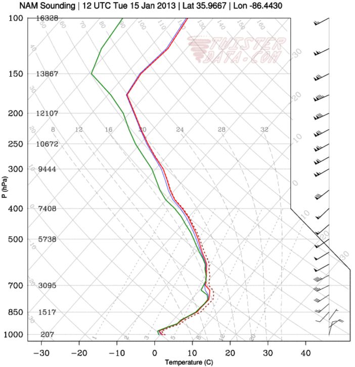
wx underground is wrong.Adam2014 wrote:No the 32 degree line is drapped across the midstate on wunderground, but you cannot take pictures of it. I would post that....
Here is the nam sounding at 84 ALL RAIN

Toot- La Vida Loca
- Posts : 6644
Join date : 2011-12-05
Location : Cocke County, TN -
Re: Jan 13-15 Arctic Boundary Ice/Sleet/Snow/Flooding threat
![]() by snowdog 2013-01-12, 11:50 am
by snowdog 2013-01-12, 11:50 am
NAM hour 72
snowdog- Winter Specialist
- Posts : 855
Join date : 2011-12-14
Age : 46
Location : Mount Juliet, TN
Re: Jan 13-15 Arctic Boundary Ice/Sleet/Snow/Flooding threat
![]() by Toot 2013-01-12, 11:53 am
by Toot 2013-01-12, 11:53 am
Last edited by Toot on 2013-01-12, 11:58 am; edited 1 time in total
Toot- La Vida Loca
- Posts : 6644
Join date : 2011-12-05
Location : Cocke County, TN -
Re: Jan 13-15 Arctic Boundary Ice/Sleet/Snow/Flooding threat
![]() by snowdog 2013-01-12, 11:58 am
by snowdog 2013-01-12, 11:58 am
snowdog- Winter Specialist
- Posts : 855
Join date : 2011-12-14
Age : 46
Location : Mount Juliet, TN
Re: Jan 13-15 Arctic Boundary Ice/Sleet/Snow/Flooding threat
![]() by Toot 2013-01-12, 11:59 am
by Toot 2013-01-12, 11:59 am
Agreed Snowdog..definately a close call situation and needs to be monitored..but it looks to be trending away from any ice situation for TNsnowdog wrote:Well this far out all you really need to know is the possibility is there.
Toot- La Vida Loca
- Posts : 6644
Join date : 2011-12-05
Location : Cocke County, TN -
Re: Jan 13-15 Arctic Boundary Ice/Sleet/Snow/Flooding threat
![]() by snowdog 2013-01-12, 12:04 pm
by snowdog 2013-01-12, 12:04 pm
snowdog- Winter Specialist
- Posts : 855
Join date : 2011-12-14
Age : 46
Location : Mount Juliet, TN
Re: Jan 13-15 Arctic Boundary Ice/Sleet/Snow/Flooding threat
![]() by Toot 2013-01-12, 12:06 pm
by Toot 2013-01-12, 12:06 pm
snowdog wrote:For the last couple of days it seems the trend was to cool this time frame. With a 1033 High sitting in NW Illinois, it is going to be really easy for the cold at the surface layer to bleed southeast.
Yeah it needs to be watched..im by no means saying that an ice event wont take place. The models could easily be underestamating the low level cold air but the trends over the last few model runs have definately been a little warmer at the surface and are now showing not much of an ice threat.
Will be watching for trends tho
Toot- La Vida Loca
- Posts : 6644
Join date : 2011-12-05
Location : Cocke County, TN -
Re: Jan 13-15 Arctic Boundary Ice/Sleet/Snow/Flooding threat
![]() by Toot 2013-01-12, 3:07 pm
by Toot 2013-01-12, 3:07 pm

I think its safe to say this wintry threat is dead

Toot- La Vida Loca
- Posts : 6644
Join date : 2011-12-05
Location : Cocke County, TN -
Re: Jan 13-15 Arctic Boundary Ice/Sleet/Snow/Flooding threat
![]() by snowdog 2013-01-12, 10:14 pm
by snowdog 2013-01-12, 10:14 pm
snowdog- Winter Specialist
- Posts : 855
Join date : 2011-12-14
Age : 46
Location : Mount Juliet, TN
Re: Jan 13-15 Arctic Boundary Ice/Sleet/Snow/Flooding threat
![]() by Toot 2013-01-13, 11:19 am
by Toot 2013-01-13, 11:19 am
Toot- La Vida Loca
- Posts : 6644
Join date : 2011-12-05
Location : Cocke County, TN -
Re: Jan 13-15 Arctic Boundary Ice/Sleet/Snow/Flooding threat
![]() by Toot 2013-01-13, 12:08 pm
by Toot 2013-01-13, 12:08 pm
4km NAM showing a mixed bag
Toot- La Vida Loca
- Posts : 6644
Join date : 2011-12-05
Location : Cocke County, TN -
Page 3 of 5 • 1, 2, 3, 4, 5 ![]()
» Early FEB snow threat
» Feb 13th/14th 2012 Snow/ice Threat
» Febuary 24-26 2012 arctic front and snow potential
» *FEBUARY 19th/20th 2012 SNOW THREAT*


