


Late Feb/Early March Potential Winter Weather
Page 4 of 8 •  1, 2, 3, 4, 5, 6, 7, 8
 ![]()
Re: Late Feb/Early March Potential Winter Weather
![]() by John1122 2013-02-24, 2:07 am
by John1122 2013-02-24, 2:07 am

John1122- Winter Specialist
- Posts : 885
Join date : 2011-12-06
Location : Campbell Co
Re: Late Feb/Early March Potential Winter Weather
![]() by Toot 2013-02-24, 7:25 am
by Toot 2013-02-24, 7:25 am
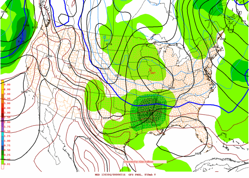
snowdog wrote:
It looks better than it actually is. Again, if you look at the skew-t's on twisterdata from hour 84 to 144 on the 00z gfs, maybe a couple of 6 hour increments shows a half way decently saturated column.
What in the hell are you talking about? The skew t's and 700..850 and 925mb graphics are the SAME exact data. The Skew t's dont magically get their data from somewhere else! LOL Its not possible to "look better than it actually is" This is meteorology not magic! lol

Toot- La Vida Loca
- Posts : 6644
Join date : 2011-12-05
Location : Cocke County, TN -

Re: Late Feb/Early March Potential Winter Weather
![]() by Toot 2013-02-24, 8:36 am
by Toot 2013-02-24, 8:36 am

Toot- La Vida Loca
- Posts : 6644
Join date : 2011-12-05
Location : Cocke County, TN -
Re: Late Feb/Early March Potential Winter Weather
![]() by Toot 2013-02-24, 8:37 am
by Toot 2013-02-24, 8:37 am

Toot- La Vida Loca
- Posts : 6644
Join date : 2011-12-05
Location : Cocke County, TN -
Re: Late Feb/Early March Potential Winter Weather
![]() by snowdog 2013-02-24, 8:46 am
by snowdog 2013-02-24, 8:46 am
John1122 wrote:That weather underground map only picks up 1+ inches of snow in a given 3 hour period. Just looking at the precip maps there are several frames of .05 3 hour periods of precip on the Euro.
Honestly there's not telling how strong a given spoke of energy will be until they're on top of you. That and timing are everything. Unless there are major changes I feel decent that Nashville and points east have a shot of 1-3 inches of snowfall if the energy passes at a favorable time of day. Most being on the lower end of that 1-3.
Much higher amounts will be possible in the favored upslope areas.
On the wundermap Euro, I was looking at MSL not snowfall. I agree that these spokes of energy are hard to model strength wise, which is why I usually try to throw in a as modeled now disclaimer. I think as things are being modeled now Nashville and any area outside of plateau/mountains (which would be the usual favored upslope areas) are looking at a dusting to 1" at the most.
snowdog- Winter Specialist
- Posts : 855
Join date : 2011-12-14
Age : 46
Location : Mount Juliet, TN
Re: Late Feb/Early March Potential Winter Weather
![]() by snowdog 2013-02-24, 8:48 am
by snowdog 2013-02-24, 8:48 am
Toot wrote:What in the hell are you talking about? The skew t's and 700..850 and 925mb graphics are the SAME exact data. The Skew t's dont magically get their data from somewhere else! LOL Its not possible to "look better than it actually is" This is meteorology not magic! lol
Come on Toot. You can spot a virga storm a mile away on skew-t's while model data will show a raging snowstorm that isn't happening.
snowdog- Winter Specialist
- Posts : 855
Join date : 2011-12-14
Age : 46
Location : Mount Juliet, TN
Re: Late Feb/Early March Potential Winter Weather
![]() by Toot 2013-02-24, 8:53 am
by Toot 2013-02-24, 8:53 am
Toot- La Vida Loca
- Posts : 6644
Join date : 2011-12-05
Location : Cocke County, TN -
Re: Late Feb/Early March Potential Winter Weather
![]() by Toot 2013-02-24, 10:18 am
by Toot 2013-02-24, 10:18 am


With good moisture..would think that would be snow givin the dynamics

Toot- La Vida Loca
- Posts : 6644
Join date : 2011-12-05
Location : Cocke County, TN -
Re: Late Feb/Early March Potential Winter Weather
![]() by Grandpa Nasty 2013-02-24, 2:27 pm
by Grandpa Nasty 2013-02-24, 2:27 pm
Will post link when I get to my laptop and off this tablet.

Grandpa Nasty- Banned
- Posts : 189
Join date : 2012-01-09
Location : Chattanooga, TN
Re: Late Feb/Early March Potential Winter Weather
![]() by John1122 2013-02-24, 3:10 pm
by John1122 2013-02-24, 3:10 pm
snowdog wrote:Toot wrote:What in the hell are you talking about? The skew t's and 700..850 and 925mb graphics are the SAME exact data. The Skew t's dont magically get their data from somewhere else! LOL Its not possible to "look better than it actually is" This is meteorology not magic! lol
Come on Toot. You can spot a virga storm a mile away on skew-t's while model data will show a raging snowstorm that isn't happening.
Virga is taken into account on model precip forecasts. And this isn't a virga situation. This will be a situation where the atmosphere is very cold and all moisture will be squeezed out in the form of snow. Because it's going to be around -10 all the way down to 850, snow will fall out of the lower levels. It'll be the kind of snow that radar will have trouble picking up along the plateau.
John1122- Winter Specialist
- Posts : 885
Join date : 2011-12-06
Location : Campbell Co
Re: Late Feb/Early March Potential Winter Weather
![]() by Jscentraltn 2013-02-24, 4:56 pm
by Jscentraltn 2013-02-24, 4:56 pm


Jscentraltn- Admin
- Posts : 703
Join date : 2013-01-19
Age : 45
Location : Cheatham county
Re: Late Feb/Early March Potential Winter Weather
![]() by John1122 2013-02-24, 5:37 pm
by John1122 2013-02-24, 5:37 pm
Jscentraltn wrote: Last 2 runs of the gfs and nam are drier and drier. Also anything that falls during the day will melt! Highs for me will still be near 40 degrees. I don't see a storm for next weekend or Monday! This has been winter for me!
The Euro is showing a Miller A in the extended that gives a good portion of Tennessee several inches.
As for the amount of moisture being modelled, it's way too far out to pay attention to that. These shortwaves are very hard to predict strength wise. The pattern is good for cold/snow showery weather. One of the shortwaves may pulse up and drop a quick 1-2 inches as it did to may areas on Super Bowl weekend.
John1122- Winter Specialist
- Posts : 885
Join date : 2011-12-06
Location : Campbell Co
Re: Late Feb/Early March Potential Winter Weather
![]() by John1122 2013-02-24, 5:49 pm
by John1122 2013-02-24, 5:49 pm
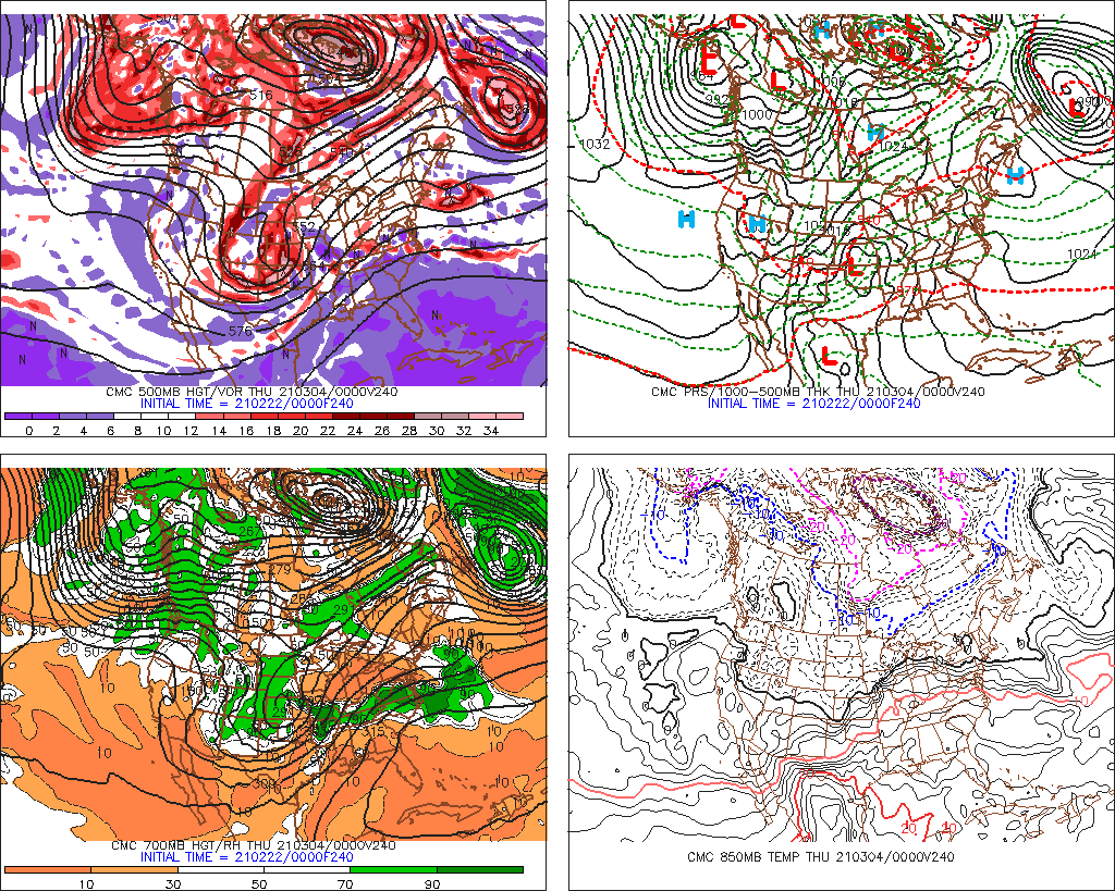
Toot wrote:From meteorologist Robert gamble
Not saying it'll happen, but this is the March 1960 setup that produced such a snow bonanza across Tennessee. It locked in in late February and stayed all month just about. Produced 3 major snow events and almost continual upslope and frigid cold.
John1122- Winter Specialist
- Posts : 885
Join date : 2011-12-06
Location : Campbell Co
Re: Late Feb/Early March Potential Winter Weather
![]() by VFL 2013-02-24, 6:22 pm
by VFL 2013-02-24, 6:22 pm
John1122 wrote:Toot wrote:From meteorologist Robert gamble
Not saying it'll happen, but this is the March 1960 setup that produced such a snow bonanza across Tennessee. It locked in in late February and stayed all month just about. Produced 3 major snow events and almost continual upslope and frigid cold.
Do. Not. Want.

VFL- Member
- Posts : 367
Join date : 2012-04-10
Age : 49
Location : North Knox County
Re: Late Feb/Early March Potential Winter Weather
![]() by John1122 2013-02-24, 6:34 pm
by John1122 2013-02-24, 6:34 pm
Because the 850s are very cold, its easy for snow to stay snow to the surface once it starts falling. This isn't a WAA scenairo, it's just the opposite, a CAA set up. Having lived in this area for decades now, I've never saw it play out that way in a CAA situation. Especially in late Feb/Early March. I've saw it set up this way in early to mid April and it still produces snow showers when the energy moves into an area.
John1122- Winter Specialist
- Posts : 885
Join date : 2011-12-06
Location : Campbell Co
Re: Late Feb/Early March Potential Winter Weather
![]() by Toot 2013-02-24, 8:26 pm
by Toot 2013-02-24, 8:26 pm
Toot- La Vida Loca
- Posts : 6644
Join date : 2011-12-05
Location : Cocke County, TN -
Re: Late Feb/Early March Potential Winter Weather
![]() by Jed33 2013-02-24, 9:25 pm
by Jed33 2013-02-24, 9:25 pm
- Attachments

- 9nhwbgconus.gif You don't have permission to download attachments.(81 Kb) Downloaded 3 times
Jed33- Admin
- Posts : 930
Join date : 2011-12-09
Location : Morristown, TN
Re: Late Feb/Early March Potential Winter Weather
![]() by ballpark 2013-02-24, 11:19 pm
by ballpark 2013-02-24, 11:19 pm
ballpark- Banned
- Posts : 155
Join date : 2011-12-07
Location : White House -
Re: Late Feb/Early March Potential Winter Weather
![]() by John1122 2013-02-25, 12:28 am
by John1122 2013-02-25, 12:28 am
John1122- Winter Specialist
- Posts : 885
Join date : 2011-12-06
Location : Campbell Co
John1122- Winter Specialist
- Posts : 885
Join date : 2011-12-06
Location : Campbell Co
Toot- La Vida Loca
- Posts : 6644
Join date : 2011-12-05
Location : Cocke County, TN -
Re: Late Feb/Early March Potential Winter Weather
![]() by Coach B 2013-02-25, 9:08 am
by Coach B 2013-02-25, 9:08 am

Coach B- Banned
- Posts : 45
Join date : 2012-02-19
Location : Marshall County
Re: Late Feb/Early March Potential Winter Weather
![]() by snowdog 2013-02-25, 9:52 am
by snowdog 2013-02-25, 9:52 am
Toot wrote:Snowdog virga is a waa feature not a caa feature..you should know this son..lol
The time frame in question is not featuring caa. It is more a feature of night time cooling along with a little wetbulbing. You can see the column saturate from hour 108 to hour 120 from this mornings 06z GFS on twisterdata. Around hour 114 you have mostly virga with maybe a very very light precip making it to the ground. Somewhere in between hour 114 and hour 120 the column fully saturates and you have a decent snow profile.
Just for clarification, the definition of virga: streaks of water drops or ice particles falling out of a cloud and evaporating before reaching the ground.
hr 108

hr 114

hr 120

snowdog- Winter Specialist
- Posts : 855
Join date : 2011-12-14
Age : 46
Location : Mount Juliet, TN
Re: Late Feb/Early March Potential Winter Weather
![]() by tom23 2013-02-25, 11:59 am
by tom23 2013-02-25, 11:59 am
tom23- Founding Member
- Posts : 298
Join date : 2012-07-06
Age : 30
Location : Jefferson City, TN

ballpark- Banned
- Posts : 155
Join date : 2011-12-07
Location : White House -
Page 4 of 8 • 1, 2, 3, 4, 5, 6, 7, 8 ![]()
» Early, Early Winter 2013/14
» Early Winter 2013/14
» March 1-2 Potential Flizzard or maybe a Little More
» Late March 2014 Snow possible


