


Valentines Day snow
Page 2 of 8 •  1, 2, 3, 4, 5, 6, 7, 8
 ![]()
Re: Valentines Day snow
![]() by Toot 2013-02-02, 6:33 pm
by Toot 2013-02-02, 6:33 pm
tennessee storm09 wrote: but now the 18z gfs still with the big storm, but its a severe setup on that run, lakes cutter
No No NO it didnt it remained concistent (which is very odd) and really gives credence to this styetm with the intense miller a

Toot- La Vida Loca
- Posts : 6644
Join date : 2011-12-05
Location : Cocke County, TN -

Re: Valentines Day snow
![]() by tennessee storm09 2013-02-02, 6:46 pm
by tennessee storm09 2013-02-02, 6:46 pm
tennessee storm09- Severe Wx Specialist
- Posts : 1304
Join date : 2011-12-05
Age : 61
Location : jackson,tennessee(home of 3 ef4 tornadoes since 1999)
Re: Valentines Day snow
![]() by Jscentraltn 2013-02-02, 8:24 pm
by Jscentraltn 2013-02-02, 8:24 pm


Jscentraltn- Admin
- Posts : 703
Join date : 2013-01-19
Age : 45
Location : Cheatham county
Re: Valentines Day snow
![]() by SEMonroeWx 2013-02-02, 8:59 pm
by SEMonroeWx 2013-02-02, 8:59 pm
SEMonroeWx- Member
- Posts : 30
Join date : 2012-12-11
Age : 46
Location : Tellico Plains
Re: Valentines Day snow
![]() by John1122 2013-02-02, 9:41 pm
by John1122 2013-02-02, 9:41 pm
John1122- Winter Specialist
- Posts : 885
Join date : 2011-12-06
Location : Campbell Co

Toot- La Vida Loca
- Posts : 6644
Join date : 2011-12-05
Location : Cocke County, TN -
Re: Valentines Day snow
![]() by tennessee storm09 2013-02-03, 12:06 am
by tennessee storm09 2013-02-03, 12:06 am
tennessee storm09- Severe Wx Specialist
- Posts : 1304
Join date : 2011-12-05
Age : 61
Location : jackson,tennessee(home of 3 ef4 tornadoes since 1999)
Re: Valentines Day snow
![]() by snowdog 2013-02-03, 12:39 am
by snowdog 2013-02-03, 12:39 am
tennessee storm09 wrote:the euro is slowly going towards the euro
You sure you aren't drunk tonight?

snowdog- Winter Specialist
- Posts : 855
Join date : 2011-12-14
Age : 46
Location : Mount Juliet, TN
Re: Valentines Day snow
![]() by tennessee storm09 2013-02-03, 9:03 am
by tennessee storm09 2013-02-03, 9:03 am
well that was before the 0z came doggie, lol... but now after that run, i edit that... this mornings 6z still squashed with our big dog valentines storm.snowdog wrote:tennessee storm09 wrote:the euro is slowly going towards the euro
You sure you aren't drunk tonight?
tennessee storm09- Severe Wx Specialist
- Posts : 1304
Join date : 2011-12-05
Age : 61
Location : jackson,tennessee(home of 3 ef4 tornadoes since 1999)
Re: Valentines Day snow
![]() by LoganMulti12 2013-02-03, 9:52 am
by LoganMulti12 2013-02-03, 9:52 am
LoganMulti12- Member
- Posts : 5
Join date : 2013-01-17
Re: Valentines Day snow
![]() by John1122 2013-02-03, 9:57 am
by John1122 2013-02-03, 9:57 am
John1122- Winter Specialist
- Posts : 885
Join date : 2011-12-06
Location : Campbell Co
Re: Valentines Day snow
![]() by tennessee storm09 2013-02-03, 10:04 am
by tennessee storm09 2013-02-03, 10:04 am
i agree with you john, after the lakes cutter... we should get into a colder pattern again... just hoping some energy can sneak up from the southern branch... middle of february to the end may be our best n perhaps last chance to cash in something big statewide, outside the laste season suprise before spring starts to wake up from the dead.John1122 wrote:At this range far better OTS than GLC. I'm just hoping a southern stream system sticks around and comes to pass during this time frame.
tennessee storm09- Severe Wx Specialist
- Posts : 1304
Join date : 2011-12-05
Age : 61
Location : jackson,tennessee(home of 3 ef4 tornadoes since 1999)
Re: Valentines Day snow
![]() by Toot 2013-02-03, 1:08 pm
by Toot 2013-02-03, 1:08 pm
Valentines day timeframe has toots signature of approval for atennessee storm09 wrote: middle of february to the end may be our best n perhaps last chance to cash in something big statewide, outside the laste season suprise before spring starts to wake up from the dead.

Toot- La Vida Loca
- Posts : 6644
Join date : 2011-12-05
Location : Cocke County, TN -
Re: Valentines Day snow
![]() by Toot 2013-02-03, 2:15 pm
by Toot 2013-02-03, 2:15 pm

Toot- La Vida Loca
- Posts : 6644
Join date : 2011-12-05
Location : Cocke County, TN -
Re: Valentines Day snow
![]() by Jed33 2013-02-03, 2:23 pm
by Jed33 2013-02-03, 2:23 pm
Jed33- Admin
- Posts : 930
Join date : 2011-12-09
Location : Morristown, TN
Re: Valentines Day snow
![]() by Grandpa Nasty 2013-02-03, 5:37 pm
by Grandpa Nasty 2013-02-03, 5:37 pm
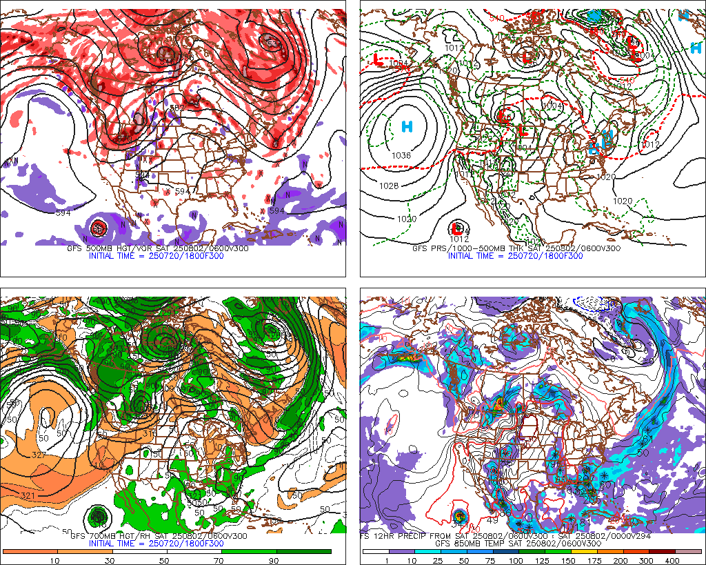
Toot wrote:This feature caught my eye on last nights euro rum. you have a low that intense I dont care 2hat progged temp profiles are..you will have yourself a major winter storm
Tooter,
I may have too many pre-game Coronas in me at the moment, so help me ou here brother. On this map it looks like the heavy heavy heavy precip is over N. Carolna with maybe a few inches from S. Tn towards knoxville. Am I looking at it wrong or does the low sling the precip back into the coldair getting sucked down and according to the map we get a nice snow and can whip up a batch of moonshine snow cream?
Sorry for the long, drawn out Corona enhanced sentences.


Grandpa Nasty- Banned
- Posts : 189
Join date : 2012-01-09
Location : Chattanooga, TN
Re: Valentines Day snow
![]() by Grandpa Nasty 2013-02-03, 5:40 pm
by Grandpa Nasty 2013-02-03, 5:40 pm
Grandpa Nasty- Banned
- Posts : 189
Join date : 2012-01-09
Location : Chattanooga, TN
Re: Valentines Day snow
![]() by Toot 2013-02-03, 5:53 pm
by Toot 2013-02-03, 5:53 pm
Grandpa Nasty wrote:
Tooter,
I may have too many pre-game Coronas in me at the moment, so help me ou here brother. On this map it looks like the heavy heavy heavy precip is over N. Carolna with maybe a few inches from S. Tn towards knoxville. Am I looking at it wrong or does the low sling the precip back into the coldair getting sucked down and according to the map we get a nice snow and can whip up a batch of moonshine snow cream?
Sorry for the long, drawn out Corona enhanced sentences.
Nasty if that verified all of us would get slammed..its a classic miller A. There is really no need to try and pinpoint where the heaviest stuff is right now because it will change. Its still ten days out and were just trying to figure out if this one is gonna cut to the lakes or gonna cut up the coast. I hope that sort of answers your question. If not just ask me a gain..and drink one for me..I have to work tomorrow
Toot- La Vida Loca
- Posts : 6644
Join date : 2011-12-05
Location : Cocke County, TN -
Re: Valentines Day snow
![]() by Jscentraltn 2013-02-03, 6:18 pm
by Jscentraltn 2013-02-03, 6:18 pm
Jscentraltn- Admin
- Posts : 703
Join date : 2013-01-19
Age : 45
Location : Cheatham county
Re: Valentines Day snow
![]() by secleveland 2013-02-03, 6:26 pm
by secleveland 2013-02-03, 6:26 pm

secleveland- Banned
- Posts : 53
Join date : 2011-12-05
Location : Meigs County
Re: Valentines Day snow
![]() by Toot 2013-02-03, 6:38 pm
by Toot 2013-02-03, 6:38 pm
Toot- La Vida Loca
- Posts : 6644
Join date : 2011-12-05
Location : Cocke County, TN -
Re: Valentines Day snow
![]() by Neals 2013-02-03, 9:26 pm
by Neals 2013-02-03, 9:26 pm
Neals- Member
- Posts : 233
Join date : 2012-10-28
Location : Cocke
Re: Valentines Day snow
![]() by Toot 2013-02-03, 9:46 pm
by Toot 2013-02-03, 9:46 pm
Toot- La Vida Loca
- Posts : 6644
Join date : 2011-12-05
Location : Cocke County, TN -
Re: Valentines Day snow
![]() by Toot 2013-02-04, 12:19 am
by Toot 2013-02-04, 12:19 am
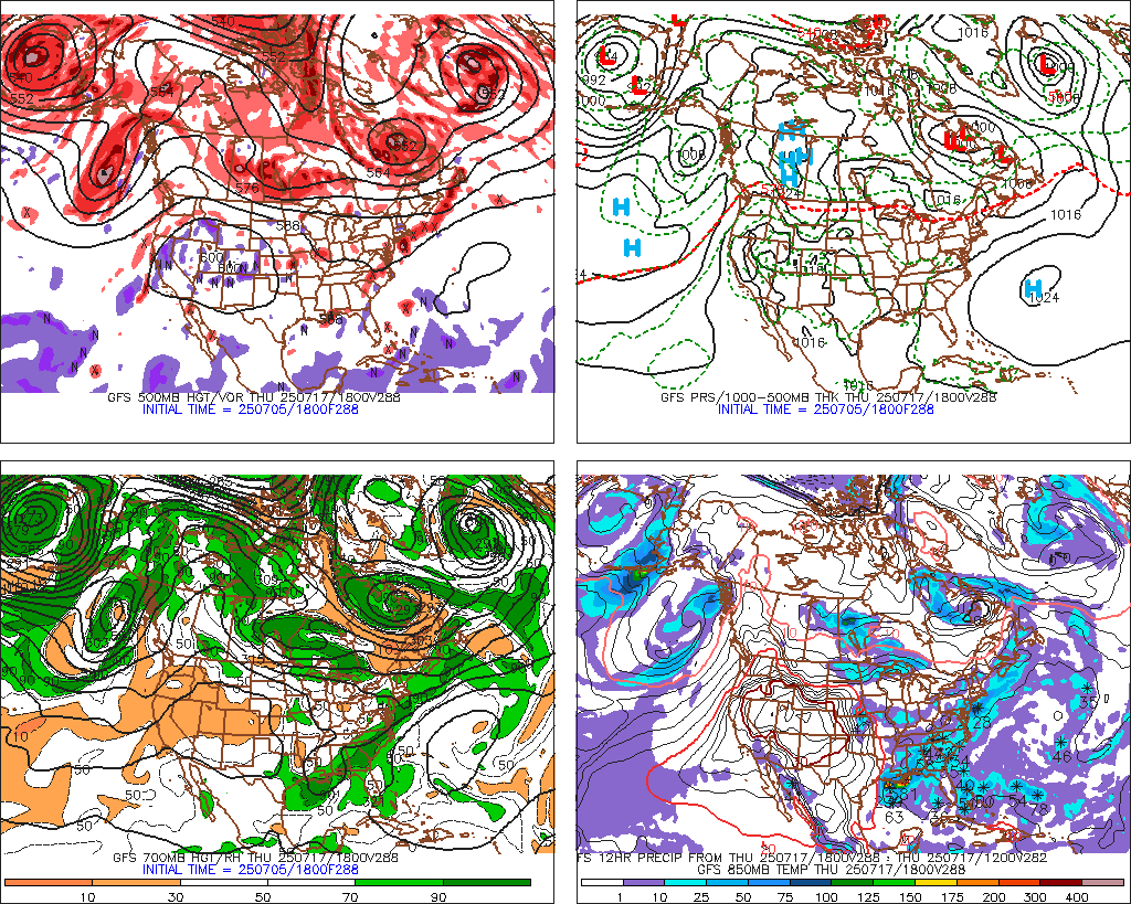
A possibly significant winter storm could affect the TN/OH Valleys..Mid Atlantic and Northeast. Its what we in the meteorology buisness call a "money in the bank" situation. An upper low or SW gets left behind in the southwestern US just meandering slowly eastward until an intense SW dives southeastward out of SW Canada. This shortwave persuades the leftover southern stream energy eastward and when the two meet up explosive cyclogenesis occurs.
Meanwhaile the circumpolar vortex being placed near Hudson bay will prevent the southern stream energy from moving northward or cutting into the great lakes region while at the same time providing a cold air source for this system to tap into. Winter weather could impact places as far south as Huntsville, AL and as far north as Maine.
Its still wayyy too early to say who.. or how much..or how strong it will be at this point as its still a week out. But it has the potential to become an intense Nor'easter. I have narrowed it down with my cone of uncertainty graphic. Laid out like this
The northern most track possible and teh southern most track possible with WXeasterns preffered track right down the middle where the lows are (Red L's)

Toot- La Vida Loca
- Posts : 6644
Join date : 2011-12-05
Location : Cocke County, TN -
Re: Valentines Day snow
![]() by godzilla 2013-02-04, 12:33 am
by godzilla 2013-02-04, 12:33 am
godzilla- Member
- Posts : 1
Join date : 2013-01-14
Location : chattanooga , tn
Page 2 of 8 • 1, 2, 3, 4, 5, 6, 7, 8 ![]()
» Early FEB snow threat
» Late season Mtn snow
» March 5-6th Winter Storm
» Accumulating Snow Possible Mar 24-26


