


**Big Dog ULL/Southern Slider Jan 17th -18th 2013**
Page 1 of 25 • 1, 2, 3 ... 13 ... 25 ![]()

**Big Dog ULL/Southern Slider Jan 17th -18th 2013**
![]() by Toot 2013-01-10, 8:17 pm
by Toot 2013-01-10, 8:17 pm
12Z euro has a statewide I-40 north snowstorm

The lastest GFS temps for the above hour on the euro


WOOF WOOF!!

Last edited by Toot on 2013-02-08, 10:26 pm; edited 7 times in total

Toot- La Vida Loca
- Posts : 6644
Join date : 2011-12-05
Location : Cocke County, TN -

Re: **Big Dog ULL/Southern Slider Jan 17th -18th 2013**
![]() by snowdog 2013-01-10, 8:47 pm
by snowdog 2013-01-10, 8:47 pm
snowdog- Winter Specialist
- Posts : 855
Join date : 2011-12-14
Age : 46
Location : Mount Juliet, TN
Re: **Big Dog ULL/Southern Slider Jan 17th -18th 2013**
![]() by Reb 2013-01-10, 9:17 pm
by Reb 2013-01-10, 9:17 pm

Reb- Admin
- Posts : 745
Join date : 2011-12-05
Location : Maryville, TN
Re: **Big Dog ULL/Southern Slider Jan 17th -18th 2013**
![]() by tom23 2013-01-10, 9:24 pm
by tom23 2013-01-10, 9:24 pm
Reb wrote:I'm about 20 miles south of I40....I guess I'll get to watch the big dog run north :/
Says he who has cashed in on the Big Dog snows that ran south of I40 for a few years now...

Hahaha
tom23- Founding Member
- Posts : 298
Join date : 2012-07-06
Age : 30
Location : Jefferson City, TN
Re: **Big Dog ULL/Southern Slider Jan 17th -18th 2013**
![]() by Reb 2013-01-10, 9:28 pm
by Reb 2013-01-10, 9:28 pm
fixed your post tommy boytom23 wrote:Reb wrote:I'm about 20 miles south of I40....I guess I'll get to watch the big dog run north :/
Says he who has cashed in on the Big Dog snows that ran south of I40 a few years ago...
Hahaha
Reb- Admin
- Posts : 745
Join date : 2011-12-05
Location : Maryville, TN
Re: **Big Dog ULL/Southern Slider Jan 17th -18th 2013**
![]() by tom23 2013-01-10, 9:41 pm
by tom23 2013-01-10, 9:41 pm
Reb wrote:fixed your post tommy boytom23 wrote:Reb wrote:I'm about 20 miles south of I40....I guess I'll get to watch the big dog run north :/
Says he who has cashed in on the Big Dog snows that ran south of I40 a few years ago...
Hahaha
Thanks Rebby Reb! Thank ye kindly!

tom23- Founding Member
- Posts : 298
Join date : 2012-07-06
Age : 30
Location : Jefferson City, TN
Re: **Big Dog ULL/Southern Slider Jan 17th -18th 2013**
![]() by Clarksville Snowman 2013-01-10, 9:54 pm
by Clarksville Snowman 2013-01-10, 9:54 pm
Clarksville Snowman- Member
- Posts : 35
Join date : 2012-12-14
Re: **Big Dog ULL/Southern Slider Jan 17th -18th 2013**
![]() by Toot 2013-01-11, 12:42 am
by Toot 2013-01-11, 12:42 am
This my latest thoughts when looking at guidance and factoring climo model biases and temp profiles. This is not a forecast just a general idea of what COULD POSSIBLY happen Jan 17-20

Toot- La Vida Loca
- Posts : 6644
Join date : 2011-12-05
Location : Cocke County, TN -
Re: **Big Dog ULL/Southern Slider Jan 17th -18th 2013**
![]() by Toot 2013-01-11, 8:17 am
by Toot 2013-01-11, 8:17 am

NOTE: Beginning 12z the hi res euro graphics will be posted in the members only section..so you will have to be a member and logged in to cointinue seeing these graphics
0z Euro

0z Nogaps

0z GFS keeps it really suppresed and then phases it just a hair too late

I really like our chances with this one and the models are right where you want them right now (except the cmc) which is suppressed and will usually come NW in a situation like this as we get closer and the phasing energy is better sampled
Last edited by Toot on 2013-01-11, 8:41 am; edited 2 times in total
Toot- La Vida Loca
- Posts : 6644
Join date : 2011-12-05
Location : Cocke County, TN -
Re: **Big Dog ULL/Southern Slider Jan 17th -18th 2013**
![]() by tom23 2013-01-11, 8:20 am
by tom23 2013-01-11, 8:20 am
With all that said, come here doggy doggy!!
tom23- Founding Member
- Posts : 298
Join date : 2012-07-06
Age : 30
Location : Jefferson City, TN
Re: **Big Dog ULL/Southern Slider Jan 17th -18th 2013**
![]() by tom23 2013-01-11, 8:22 am
by tom23 2013-01-11, 8:22 am
tom23- Founding Member
- Posts : 298
Join date : 2012-07-06
Age : 30
Location : Jefferson City, TN
Re: **Big Dog ULL/Southern Slider Jan 17th -18th 2013**
![]() by Toot 2013-01-11, 8:34 am
by Toot 2013-01-11, 8:34 am
tom23 wrote:Looks like it *could* be south of I-40 like the past few snowstorms have been for this area, Toot. We always set our hopes on the NW trend, but it just hasn't happened that way the past few big dog snows. At least not enough for I-40 north to be able to pick up a good chunk of it
Storms this year have mostly all trended drastically NW and gulf low precip shields are ALWAYS undestimated by models to the north of the low. IMO this is the best shot we have had at a good snow since 2010 but like you said we are just monitoring it right now and excitement levels should be somewhat tempered right now due to it being a week out. That said the setup looks pretty solid H5 wise..and with the big arctic high to the north. No way this satys suppressed but it could certainly trend too far NW which would mean more WAA and less frozen precip.
Fun pattern that is about to take hold

Toot- La Vida Loca
- Posts : 6644
Join date : 2011-12-05
Location : Cocke County, TN -
Re: **Big Dog ULL/Southern Slider Jan 17th -18th 2013**
![]() by tom23 2013-01-11, 8:41 am
by tom23 2013-01-11, 8:41 am
tom23- Founding Member
- Posts : 298
Join date : 2012-07-06
Age : 30
Location : Jefferson City, TN
Re: **Big Dog ULL/Southern Slider Jan 17th -18th 2013**
![]() by snowdog 2013-01-11, 9:21 am
by snowdog 2013-01-11, 9:21 am
snowdog- Winter Specialist
- Posts : 855
Join date : 2011-12-14
Age : 46
Location : Mount Juliet, TN
Re: **Big Dog ULL/Southern Slider Jan 17th -18th 2013**
![]() by Toot 2013-01-11, 1:54 pm
by Toot 2013-01-11, 1:54 pm

Toot- La Vida Loca
- Posts : 6644
Join date : 2011-12-05
Location : Cocke County, TN -
Re: **Big Dog ULL/Southern Slider Jan 17th -18th 2013**
![]() by ballpark 2013-01-11, 1:59 pm
by ballpark 2013-01-11, 1:59 pm
ballpark- Banned
- Posts : 155
Join date : 2011-12-07
Location : White House -
Re: **Big Dog ULL/Southern Slider Jan 17th -18th 2013**
![]() by Jed33 2013-01-11, 2:01 pm
by Jed33 2013-01-11, 2:01 pm
Jed33- Admin
- Posts : 930
Join date : 2011-12-09
Location : Morristown, TN
Re: **Big Dog ULL/Southern Slider Jan 17th -18th 2013**
![]() by Toot 2013-01-12, 12:27 am
by Toot 2013-01-12, 12:27 am

Toot- La Vida Loca
- Posts : 6644
Join date : 2011-12-05
Location : Cocke County, TN -
Re: **Big Dog ULL/Southern Slider Jan 17th -18th 2013**
![]() by Toot 2013-01-12, 12:25 pm
by Toot 2013-01-12, 12:25 pm
Graphics are posted in the members only section
Toot- La Vida Loca
- Posts : 6644
Join date : 2011-12-05
Location : Cocke County, TN -
Re: **Big Dog ULL/Southern Slider Jan 17th -18th 2013**
![]() by Toot 2013-01-12, 1:13 pm
by Toot 2013-01-12, 1:13 pm

Toot- La Vida Loca
- Posts : 6644
Join date : 2011-12-05
Location : Cocke County, TN -
Re: **Big Dog ULL/Southern Slider Jan 17th -18th 2013**
![]() by jmundie 2013-01-12, 2:14 pm
by jmundie 2013-01-12, 2:14 pm
jmundie- Winter Specialist
- Posts : 743
Join date : 2011-12-19
Re: **Big Dog ULL/Southern Slider Jan 17th -18th 2013**
![]() by Toot 2013-01-12, 2:24 pm
by Toot 2013-01-12, 2:24 pm
jmundie wrote:isn't that the 22nd? you're big dog storm has actually disappeared from the euro. It was holding the energy back (surprise)
Yes..I suppose the gfs and the euro are holding back now but well see..anyways the big dog was on last nights run of the euro. You'll see it come back..just too much energy for the models to try peg it every single run. Im pretty confident you and I will be pretty happy snowwise around the 17th -22nd period. IMO It will take the models a while to lock onto it but the pattern is there and supportive for a major snowstorm.
Toot- La Vida Loca
- Posts : 6644
Join date : 2011-12-05
Location : Cocke County, TN -
Re: **Big Dog ULL/Southern Slider Jan 17th -18th 2013**
![]() by jmundie 2013-01-12, 2:44 pm
by jmundie 2013-01-12, 2:44 pm
Toot wrote:jmundie wrote:isn't that the 22nd? you're big dog storm has actually disappeared from the euro. It was holding the energy back (surprise)
Yes..I suppose the gfs and the euro are holding back now but well see..anyways the big dog was on last nights run of the euro. You'll see it come back..just too much energy for the models to try peg it every single run. Im pretty confident you and I will be pretty happy snowwise around the 17th -22nd period. IMO It will take the models a while to lock onto it but the pattern is there and supportive for a major snowstorm.
No - What I'm saying is the euro was holding the energy back... it now releases it and gets squashed mid week. The energy is going to have to get stuck in the s/w for a storm next weekend when the flow flattens out a bit to allow it to come underneath before the pv drops in day 10.
jmundie- Winter Specialist
- Posts : 743
Join date : 2011-12-19
Re: **Big Dog ULL/Southern Slider Jan 17th -18th 2013**
![]() by Toot 2013-01-12, 2:55 pm
by Toot 2013-01-12, 2:55 pm
jmundie wrote:
No - What I'm saying is the euro was holding the energy back... it now releases it and gets squashed mid week. The energy is going to have to get stuck in the s/w for a storm next weekend when the flow flattens out a bit to allow it to come underneath before the pv drops in day 10.
Yeah I understood..the GFS is now holding back too but the gfs doesnt get squashe it turns into a noreaster which is prob waht the euro will eventually come to...Fun times Mundie..Glad ur back posting over here again. I appreciate your knowledge
Toot- La Vida Loca
- Posts : 6644
Join date : 2011-12-05
Location : Cocke County, TN -
Re: **Big Dog ULL/Southern Slider Jan 17th -18th 2013**
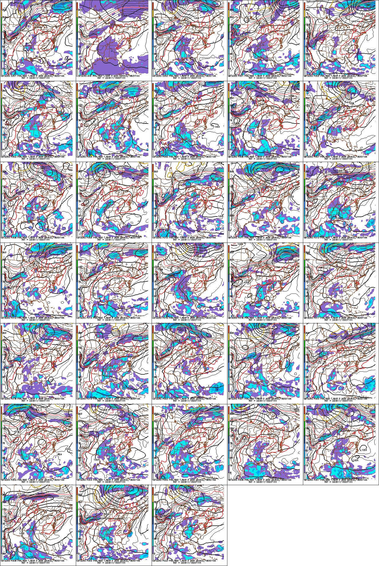
![]() by Toot 2013-01-12, 7:26 pm
by Toot 2013-01-12, 7:26 pm

18z Gfs Ensembles
Toot- La Vida Loca
- Posts : 6644
Join date : 2011-12-05
Location : Cocke County, TN -
Page 1 of 25 • 1, 2, 3 ... 13 ... 25 ![]()
» Big storm system 16th-18th
» Winter Storm Threat 16th-18th
» January 17th
» Winter Wx Discussion 2013/14


