


Fall 2012 wx discussion
Page 6 of 15 •  1 ... 5, 6, 7 ... 10 ... 15
 ![]()
Re: Fall 2012 wx discussion
![]() by Toot 2012-10-10, 8:05 am
by Toot 2012-10-10, 8:05 am
6z 4km NAM lows


Toot- La Vida Loca
- Posts : 6644
Join date : 2011-12-05
Location : Cocke County, TN -

Re: Fall 2012 wx discussion
![]() by Toot 2012-10-11, 9:00 am
by Toot 2012-10-11, 9:00 am


Meanwhile..they are getting ready to peak above 4000 ft!

Toot- La Vida Loca
- Posts : 6644
Join date : 2011-12-05
Location : Cocke County, TN -
Re: Fall 2012 wx discussion
![]() by snowdog 2012-10-11, 9:57 am
by snowdog 2012-10-11, 9:57 am
snowdog- Winter Specialist
- Posts : 855
Join date : 2011-12-14
Age : 46
Location : Mount Juliet, TN
Re: Fall 2012 wx discussion
![]() by John1122 2012-10-11, 4:15 pm
by John1122 2012-10-11, 4:15 pm
John1122- Winter Specialist
- Posts : 885
Join date : 2011-12-06
Location : Campbell Co
Re: Fall 2012 wx discussion
![]() by Stovepipe 2012-10-12, 9:05 am
by Stovepipe 2012-10-12, 9:05 am


Stovepipe- Founding Member
- Posts : 4148
Join date : 2011-12-05
Age : 48
Location : Knoxville, TN -
Re: Fall 2012 wx discussion
![]() by Toot 2012-10-12, 1:59 pm
by Toot 2012-10-12, 1:59 pm
Toot- La Vida Loca
- Posts : 6644
Join date : 2011-12-05
Location : Cocke County, TN -
Re: Fall 2012 wx discussion
![]() by Toot 2012-10-13, 5:18 pm
by Toot 2012-10-13, 5:18 pm
Models have came into better agreement with system that was in the extended. Teleconnection signals along with guidance models favor an intense storm system over the eastern US during the Oct 18-20th timeframe. This system will carry the possibility of severe storms in the OH and TN valleys along with the possibility of cold advected snow showers in the Appalachians/OH valley!!

Toot- La Vida Loca
- Posts : 6644
Join date : 2011-12-05
Location : Cocke County, TN -
Re: Fall 2012 wx discussion
![]() by tennessee storm09 2012-10-13, 6:41 pm
by tennessee storm09 2012-10-13, 6:41 pm
yep, 85 degrees for high today... actually even mowed the yard late this afternoon.Toot wrote:I noticed it got into the 80's out towards the Memphis area today. Enjoy the shortlived warmup while you can the next couple of days because another cold intrusion looks likely in the extended.
Models have came into better agreement with system that was in the extended. Teleconnection signals along with guidance models favor an intense storm system over the eastern US during the Oct 18-20th timeframe. This system will carry the possibility of severe storms in the OH and TN valleys along with the possibility of cold advected snow showers in the Appalachians/OH valley!!
tennessee storm09- Severe Wx Specialist
- Posts : 1304
Join date : 2011-12-05
Age : 61
Location : jackson,tennessee(home of 3 ef4 tornadoes since 1999)
Re: Fall 2012 wx discussion
![]() by tennessee storm09 2012-10-13, 6:53 pm
by tennessee storm09 2012-10-13, 6:53 pm
but its the same song, tune and dance... both euro and gfs has the main energy way north again on this one also... looks like a possible linear type with iso severe... i like the looks of the euro on long range for a big system around last week of month... that one has the possibility to be further south as better blocking signals start to take shape... euro isnt to bullish with the cold as gfs isToot wrote:I noticed it got into the 80's out towards the Memphis area today. Enjoy the shortlived warmup while you can the next couple of days because another cold intrusion looks likely in the extended.
Models have came into better agreement with system that was in the extended. Teleconnection signals along with guidance models favor an intense storm system over the eastern US during the Oct 18-20th timeframe. This system will carry the possibility of severe storms in the OH and TN valleys along with the possibility of cold advected snow showers in the Appalachians/OH valley!!
tennessee storm09- Severe Wx Specialist
- Posts : 1304
Join date : 2011-12-05
Age : 61
Location : jackson,tennessee(home of 3 ef4 tornadoes since 1999)
Re: Fall 2012 wx discussion
![]() by andyhb 2012-10-14, 1:10 am
by andyhb 2012-10-14, 1:10 am

andyhb- Severe Wx Specialist
- Posts : 84
Join date : 2012-03-26
Re: Fall 2012 wx discussion
![]() by tennessee storm09 2012-10-14, 1:14 am
by tennessee storm09 2012-10-14, 1:14 am
i agree 100 percent on that... return gulf flow looks very meager... o well maybe later in the monthandyhb wrote:Moisture is crap, I strongly doubt we'll see much of a severe threat with the system next week, regardless of how strong it is.
tennessee storm09- Severe Wx Specialist
- Posts : 1304
Join date : 2011-12-05
Age : 61
Location : jackson,tennessee(home of 3 ef4 tornadoes since 1999)
Re: Fall 2012 wx discussion
![]() by andyhb 2012-10-14, 2:49 am
by andyhb 2012-10-14, 2:49 am
andyhb- Severe Wx Specialist
- Posts : 84
Join date : 2012-03-26
Re: Fall 2012 wx discussion
![]() by tennessee storm09 2012-10-14, 11:45 am
by tennessee storm09 2012-10-14, 11:45 am
tennessee storm09- Severe Wx Specialist
- Posts : 1304
Join date : 2011-12-05
Age : 61
Location : jackson,tennessee(home of 3 ef4 tornadoes since 1999)
Re: Fall 2012 wx discussion
![]() by Toot 2012-10-14, 2:16 pm
by Toot 2012-10-14, 2:16 pm
tennessee storm09 wrote:but its the same song, tune and dance... both euro and gfs has the main energy way north again on this one also... looks like a possible linear type with iso severe
I wouldnt underestimate this systems potential. Im not saying its gonna be big deal or anything but it is kind of odd that all guidance models are progging this one into the 980mb range and some are even going further into the 970Mb range. There are several signals that suggest this is gonna be an intense system. You seem to have forgot a storm that had its center displaced WELL north of here (Just like this one is progged) just two years ago in the month of October.
SPC storm reports for Oct 26 2010

Satellite images from Oct 26 2010

NARR reanalysis for Oct 26 2010
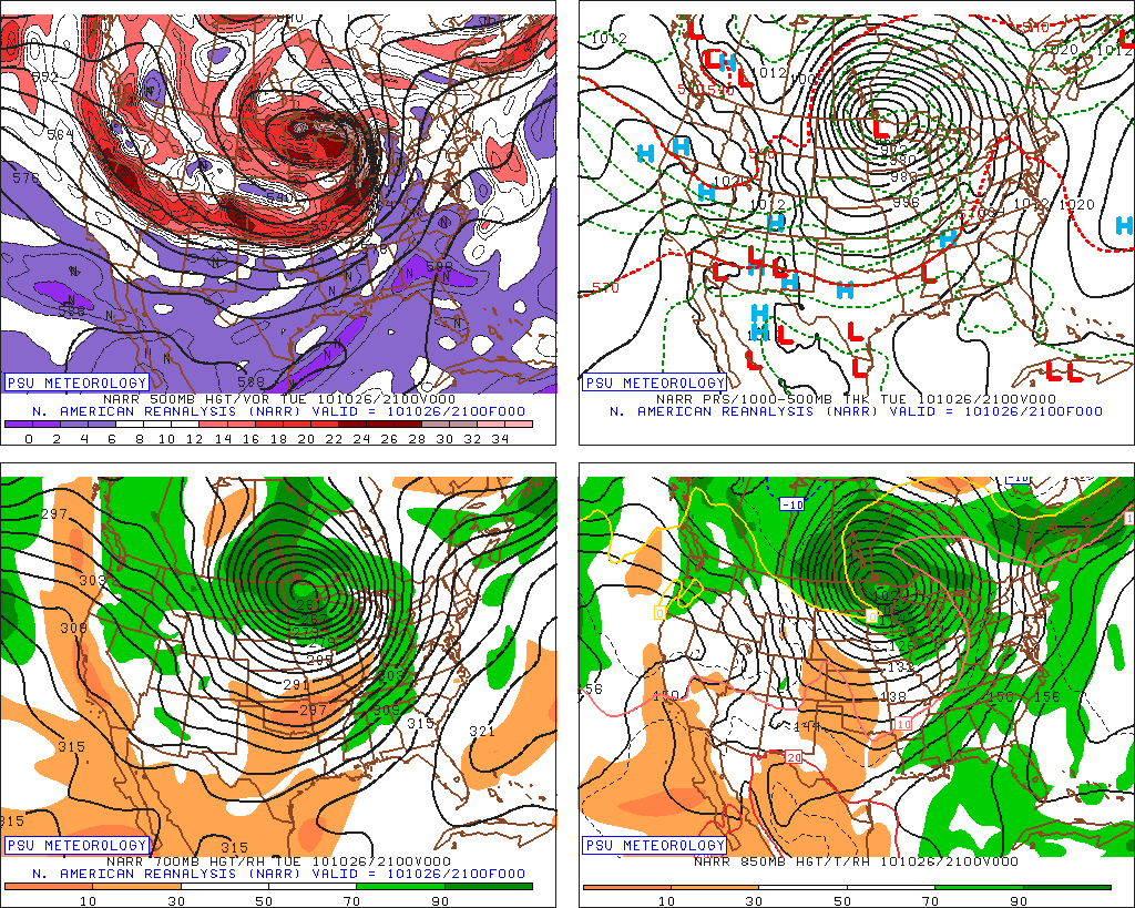
And finally todays 12zGFS is progging this one as low as 977Mb


That is a big boy low pressure system right there

Last edited by Toot on 2012-10-14, 2:25 pm; edited 1 time in total
Toot- La Vida Loca
- Posts : 6644
Join date : 2011-12-05
Location : Cocke County, TN -
Re: Fall 2012 wx discussion
![]() by tennessee storm09 2012-10-14, 2:24 pm
by tennessee storm09 2012-10-14, 2:24 pm
Toot wrote:tennessee storm09 wrote:but its the same song, tune and dance... both euro and gfs has the main energy way north again on this one also... looks like a possible linear type with iso severe
I wouldnt underestimate this systems potential. Im not saying its gonna be big deal or anything but it is kind of odd that all guidance models are progging this one into the 980mb range and some are even going further into the 970Mb range. There are several signals that suggest this is gonna be an intense system. You seem to have forgot a storm that had its center displaced WELL north of here (Just like this one is progged) just two years ago in the month of October.
That is a big boy low pressure system right there
great point there toot, yeah i remember that particular system...cause we didnt get as much as areas to the north and east of me... o trust me i have seen some nice systems effect us even if the slp was way north... and yeah 970 mb... now thats a strong low buddy... still lot depends on return flow of low level moisture, course get a little more instability will only help.
tennessee storm09- Severe Wx Specialist
- Posts : 1304
Join date : 2011-12-05
Age : 61
Location : jackson,tennessee(home of 3 ef4 tornadoes since 1999)
Re: Fall 2012 wx discussion
![]() by snowdog 2012-10-14, 3:48 pm
by snowdog 2012-10-14, 3:48 pm
snowdog- Winter Specialist
- Posts : 855
Join date : 2011-12-14
Age : 46
Location : Mount Juliet, TN
Re: Fall 2012 wx discussion
![]() by andyhb 2012-10-14, 4:23 pm
by andyhb 2012-10-14, 4:23 pm
andyhb- Severe Wx Specialist
- Posts : 84
Join date : 2012-03-26
Re: Fall 2012 wx discussion
![]() by jmundie 2012-10-14, 4:43 pm
by jmundie 2012-10-14, 4:43 pm
snowdog wrote:Last few runs of the Euro remind me a lot of last years pattern in the fall.
Yep. Big cut off lows and negative pna. Though it looks less negative today than the last couple runs.
jmundie- Winter Specialist
- Posts : 743
Join date : 2011-12-19
Re: Fall 2012 wx discussion
![]() by Toot 2012-10-14, 5:35 pm
by Toot 2012-10-14, 5:35 pm
If the analogs are correct for November the pattern should become aligned in a less blocky config in the higher latitudes at 500mb and possibly a warm alignment in the +NAO/AO -PNA indices. Im expecting Nov to be the warmest month of the fall!snowdog wrote:Last few runs of the Euro remind me a lot of last years pattern in the fall.
Toot- La Vida Loca
- Posts : 6644
Join date : 2011-12-05
Location : Cocke County, TN -
Re: Fall 2012 wx discussion
![]() by andyhb 2012-10-14, 7:09 pm
by andyhb 2012-10-14, 7:09 pm
The 18z GFS also indicates a very large upper trough developing across the western half of the country towards the end of its higher-res range, with a powerful Pacific jet diving down its backside, monitor this for future model continuity, the Euro has had something similar to this for several runs in a row now.
andyhb- Severe Wx Specialist
- Posts : 84
Join date : 2012-03-26
Re: Fall 2012 wx discussion
![]() by andyhb 2012-10-14, 7:59 pm
by andyhb 2012-10-14, 7:59 pm


Last edited by andyhb on 2012-10-14, 8:01 pm; edited 1 time in total
andyhb- Severe Wx Specialist
- Posts : 84
Join date : 2012-03-26
Re: Fall 2012 wx discussion
![]() by tennessee storm09 2012-10-14, 8:01 pm
by tennessee storm09 2012-10-14, 8:01 pm
yea, andy i still like the looks of the pacific jet streakiing out west in longer range...andyhb wrote:Well, the NAM is interesting, gets some noteworthy instability into the Ozarks, which would be more than enough to support a severe threat given the strong dynamics associated with this trough, although this is the NAM in the later portions of its run, so take this with a grain of salt.
The 18z GFS also indicates a very large upper trough developing across the western half of the country towards the end of its higher-res range, with a powerful Pacific jet diving down its backside, monitor this for future model continuity, the Euro has had something similar to this for several runs in a row now.
tennessee storm09- Severe Wx Specialist
- Posts : 1304
Join date : 2011-12-05
Age : 61
Location : jackson,tennessee(home of 3 ef4 tornadoes since 1999)
Re: Fall 2012 wx discussion
![]() by Toot 2012-10-14, 8:07 pm
by Toot 2012-10-14, 8:07 pm
andyhb wrote:As you see on the 15z SREF, the probability of getting 60s dews to Cairo is fairly high, as well as getting 200+ m2/s2 of 0-3 km SRH...
IMO dewpoints and any aspect of warm advection is probably severely underestimated by models at this point.
Toot- La Vida Loca
- Posts : 6644
Join date : 2011-12-05
Location : Cocke County, TN -
Re: Fall 2012 wx discussion
![]() by Toot 2012-10-16, 8:12 am
by Toot 2012-10-16, 8:12 am
Toot- La Vida Loca
- Posts : 6644
Join date : 2011-12-05
Location : Cocke County, TN -
jmundie- Winter Specialist
- Posts : 743
Join date : 2011-12-19
Page 6 of 15 • 1 ... 5, 6, 7 ... 10 ... 15 ![]()
» Fall wx discussion 2014/2015
» Summer 2012 WX Discussion
» Fall Outlook for 2014
» Spring 2012 weather discussion


