


Hurricane Isaac
Page 1 of 4 • 1, 2, 3, 4 ![]()

Hurricane Isaac
![]() by Toot 2012-08-21, 8:30 am
by Toot 2012-08-21, 8:30 am
Good Morning!!
A tropical cyclone has formed this morning in the central Atlantic. Its a rather large system so it will take a while to become organized. There is an anomalously strong subtropical high pressure system to the systems north which should keep any recurve out to sea possibility rather low.
Guidance does indicate a possible weakness near the east coast and if the system were to gain organization quickly then an east coast landfall would not be out of the question in my opinion. Right now it looks like Florida is the most likely state that could be in the crosshairs of this system.
The intensity and track forecast are both rather tricky. Ive outlined the areas in red that this system could still possibly affect. There is many obstacles that will more than likely keep this from becoming a strong hurricane...but it doesnt take a strong Hurricane to cause damage. If you reside in or close to the red shaded area I suggest you keep your eye on this system!

This is a possible threat to the SE US..so I thought it was threadworthy
Last edited by Toot on 2012-08-28, 6:40 pm; edited 3 times in total

Toot- La Vida Loca
- Posts : 6644
Join date : 2011-12-05
Location : Cocke County, TN -

Re: Hurricane Isaac
![]() by tennessee storm09 2012-08-21, 8:42 am
by tennessee storm09 2012-08-21, 8:42 am
tennessee storm09- Severe Wx Specialist
- Posts : 1304
Join date : 2011-12-05
Age : 61
Location : jackson,tennessee(home of 3 ef4 tornadoes since 1999)
Re: Hurricane Isaac
![]() by Toot 2012-08-21, 5:37 pm
by Toot 2012-08-21, 5:37 pm
They also adjusted their track northward after having it south of the islands and into the gulf this morning

Still disorganized..that will probably change tonight

Toot- La Vida Loca
- Posts : 6644
Join date : 2011-12-05
Location : Cocke County, TN -
Re: Hurricane Isaac
![]() by Toot 2012-08-21, 5:57 pm
by Toot 2012-08-21, 5:57 pm


Nogaps and CMC are east strong hurricanes on the east coast..

Im going with the weasker gfs at this point that sends it into FL
Toot- La Vida Loca
- Posts : 6644
Join date : 2011-12-05
Location : Cocke County, TN -
Re: Hurricane Isaac
![]() by skillsweather 2012-08-21, 6:48 pm
by skillsweather 2012-08-21, 6:48 pm
I would bet that is what will make the path for this hurricane. If it can gain alot of strength then it will move more west but if it cant then it will get sucked into or blocked by a nearby whatever (trough, low,high or whatever lol). But idk just what I am guessing. Am I anywhere near close?
skillsweather- Banned
- Posts : 313
Join date : 2011-12-06
Age : 32
Location : tennessee Wilson county Ne Corner
Re: Hurricane Isaac
![]() by Toot 2012-08-21, 7:02 pm
by Toot 2012-08-21, 7:02 pm
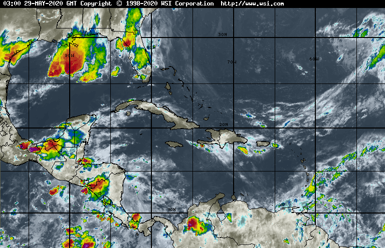
Tropical storm Isaac has been deemed by the National Hurricane center this evening. His pressure is currently listed at 1006Mb with his winds at 40MPH.
Still no agreement on his track.. as the Euro has a major hurricane in the gulf of Mexico..the Canadian model has major Hurricane in the Carolinas and the GFS right between those two as it takes a weaker cyclone into Florida.
One thing that has changed in guidance is the intensity!! Most of guidance has trended much stronger with this storm and people on the gulf and east coasts need to be paying close attention to this system... as there is alot of uncertainty amongst guidance as far as track goes.
Isaac has moved into warmer waters and away from alot of the dry air and shear that hampered development for quite a while. As far as intensity goes.. I expect Isaac to become a hurricane late tomorrow night into the AM. After that.. its really up to the precise stormtrack as to how strong he becomes. If he misses the higher elevated islands.. then a strong Hurricane becomes that much more likely.
Here is my latest idea of where Isaac is possibly headed! Notice how HUGE this cyclone is..I put a big red circle around all the cloud tops that he is currently banding

https://www.facebook.com/Wxeast
Last edited by Toot on 2012-08-21, 7:10 pm; edited 1 time in total
Toot- La Vida Loca
- Posts : 6644
Join date : 2011-12-05
Location : Cocke County, TN -
Re: Hurricane Isaac
![]() by Toot 2012-08-21, 7:06 pm
by Toot 2012-08-21, 7:06 pm
skillsweather wrote: If it can gain alot of strength then it will move more west
Normally in the atlantic..the stronger the more poleward (North) the cyclone goes. The weaker the more west it will make it
Toot- La Vida Loca
- Posts : 6644
Join date : 2011-12-05
Location : Cocke County, TN -

tennessee storm09- Severe Wx Specialist
- Posts : 1304
Join date : 2011-12-05
Age : 61
Location : jackson,tennessee(home of 3 ef4 tornadoes since 1999)
Re: Hurricane Isaac
![]() by Toot 2012-08-22, 8:32 am
by Toot 2012-08-22, 8:32 am
Tropical storm Isaac has definately consolidated this morning as his circulation seems to have become tighter as he has taken on a more classic look.
I have not been able to narrow my cone of uncertainty down at all. Guidance believe or not.. is still not agreeing on much. GFS/CMC/ECM all have a completely different scenario. Even though the GFS has trended stronger this morning. The ECM still represents the worse case scenario with a "Katrinaisk" type storm and track.
Everybody on any coastline in the southeastern US should be on guard as this is looking more and more like a legitimate threat.
This mornings 0z ECM is no joke if its correct

Toot- La Vida Loca
- Posts : 6644
Join date : 2011-12-05
Location : Cocke County, TN -
Re: Hurricane Isaac
![]() by Vanster67 2012-08-22, 8:42 am
by Vanster67 2012-08-22, 8:42 am
Boy, that just looks SCARY anywhere it would go. Stay away from my Family in Florida~!!!!Toot wrote:Good Morning
Tropical storm Isaac has definately consolidated this morning as his circulation seems to have become tighter as he has taken on a more classic look.
I have not been able to narrow my cone of uncertainty down at all. Guidance believe or not.. is still not agreeing on much. GFS/CMC/ECM all have a completely different scenario. Even though the GFS has trended stronger this morning. The ECM still represents the worse case scenario with a "Katrinaisk" type storm and track.
Everybody on any coastline in the southeastern US should be on guard as this is looking more and more like a legitimate threat.
This mornings 0z ECM is no joke if its correct


Vanster67- Admin
- Posts : 629
Join date : 2011-12-08
Age : 57
Location : Monterey, TN
Re: Hurricane Isaac
![]() by Toot 2012-08-22, 8:53 am
by Toot 2012-08-22, 8:53 am

This is the cone from exactly one year ago to the day for Hurricane Irene...lol look familiar?


Of course Irene played tricks on the NHC...lol
This is what verified

Toot- La Vida Loca
- Posts : 6644
Join date : 2011-12-05
Location : Cocke County, TN -
Re: Hurricane Isaac
![]() by snowdog 2012-08-22, 8:57 am
by snowdog 2012-08-22, 8:57 am
snowdog- Winter Specialist
- Posts : 855
Join date : 2011-12-14
Age : 46
Location : Mount Juliet, TN
Re: Hurricane Isaac
![]() by Toot 2012-08-22, 9:22 am
by Toot 2012-08-22, 9:22 am
This is gonna be a fun one to track. If the Euro is correct...I hope the people in New Orleans learned a lesson.
Im reminded of the FEMA evactuation plan "Run Bitch Run"..lmao!!
Toot- La Vida Loca
- Posts : 6644
Join date : 2011-12-05
Location : Cocke County, TN -
Re: Hurricane Isaac
![]() by windstorm 2012-08-22, 1:00 pm
by windstorm 2012-08-22, 1:00 pm

windstorm- Member
- Posts : 891
Join date : 2012-03-26
Location : Harrison, tn
Re: Hurricane Isaac
![]() by Toot 2012-08-22, 6:17 pm
by Toot 2012-08-22, 6:17 pm
Tropical storm Isaac continues to churn in the Carribean this evening with pressures of 1004Mb and winds of 45 MPH. He is a very large system...in fact he is large enough to have two competing circulations. This is the only reason why he is still rather weak at the moment.
One of the circulations will likely become dominant sometime tonight into the morning. Satellite presentation will become more organized and his pressure will then begin to drop. Wind speeds will start race upward as he moves WNW. Guidance has become a little clearer today with the track of this system...therefore I have began to narrow the cone of uncertainty down on my forecast.
Intensity forecast is still a crap shoot due to all the islands that he could possibly interact with. But guidance has also become much stronger with that again today. His look on satellite is steadily improving...so it probably wont be long until we get a clearer picture of how impressive/large this cyclone will be when he starts wrapping convection around one center instead of two!
Here is the updated cone with a a track line and a general intensity forecast.

Toot- La Vida Loca
- Posts : 6644
Join date : 2011-12-05
Location : Cocke County, TN -
Re: Hurricane Isaac
![]() by tennessee storm09 2012-08-22, 7:20 pm
by tennessee storm09 2012-08-22, 7:20 pm
tennessee storm09- Severe Wx Specialist
- Posts : 1304
Join date : 2011-12-05
Age : 61
Location : jackson,tennessee(home of 3 ef4 tornadoes since 1999)
Re: Hurricane Isaac
![]() by tennessee storm09 2012-08-22, 11:18 pm
by tennessee storm09 2012-08-22, 11:18 pm
tennessee storm09- Severe Wx Specialist
- Posts : 1304
Join date : 2011-12-05
Age : 61
Location : jackson,tennessee(home of 3 ef4 tornadoes since 1999)
Re: Hurricane Isaac
![]() by Toot 2012-08-23, 8:59 am
by Toot 2012-08-23, 8:59 am
Even though satellite presentation continues to improve the storm still lacks deep organization. The size of this storm is slowing the intensification rate down compared to what I first thought but sooner or later Isaac will go boom. Im still going with yesterdays track and forecast cone.
In other news this morning...The 0z Euro trended slightly east. I imagine it will keep trending east until it lines up more with the GFS and its ensembles.
0z EURO model

Consensus

Toot- La Vida Loca
- Posts : 6644
Join date : 2011-12-05
Location : Cocke County, TN -
jmundie- Winter Specialist
- Posts : 743
Join date : 2011-12-19
Re: Hurricane Isaac
![]() by skillsweather 2012-08-23, 2:56 pm
by skillsweather 2012-08-23, 2:56 pm
skillsweather- Banned
- Posts : 313
Join date : 2011-12-06
Age : 32
Location : tennessee Wilson county Ne Corner
Re: Hurricane Isaac
![]() by Toot 2012-08-23, 3:07 pm
by Toot 2012-08-23, 3:07 pm

Toot- La Vida Loca
- Posts : 6644
Join date : 2011-12-05
Location : Cocke County, TN -
Re: Hurricane Isaac
![]() by Toot 2012-08-23, 5:06 pm
by Toot 2012-08-23, 5:06 pm
As you can see I have finally ruled out an east coast landfall as Isaac has drifted far enough west to no longer be a wind threat to anyone on the east coast. We have also shifted our track west and have kept it at Tropical storm status longer due to unexpected dry air infiltration.
Isaac is still very disorganized due to this dry air and two competing centers. He is drifting mostly west but this mostly westward motion will halt when he decides to intensify.. and he will sooner or later!! Then..more of a NW trajectory will take over. This updated track puts Isaac over warmer water much longer than the previous track did!
Therefore Isaac has a high probability of becoming a strong- major hurricane at some point on his visit to the gulf!

Toot- La Vida Loca
- Posts : 6644
Join date : 2011-12-05
Location : Cocke County, TN -
Re: Hurricane Isaac
![]() by tennessee storm09 2012-08-23, 6:53 pm
by tennessee storm09 2012-08-23, 6:53 pm
tennessee storm09- Severe Wx Specialist
- Posts : 1304
Join date : 2011-12-05
Age : 61
Location : jackson,tennessee(home of 3 ef4 tornadoes since 1999)
Re: Hurricane Isaac
![]() by Toot 2012-08-23, 7:07 pm
by Toot 2012-08-23, 7:07 pm
Toot- La Vida Loca
- Posts : 6644
Join date : 2011-12-05
Location : Cocke County, TN -
Re: Hurricane Isaac
![]() by Dyersburg Weather 2012-08-23, 9:44 pm
by Dyersburg Weather 2012-08-23, 9:44 pm
Toot wrote:I wouldnt rule out a Florida landfall nor would I rule out a Louisiana Landfall. This is a very complex situation as to which part of the gulf this landfalls in.
Most of those tracks would work for me. We need a good 6 to 8 inch tropical rain.


Dyersburg Weather- Banned
- Posts : 342
Join date : 2011-12-25
Age : 55
Location : Dyersburg , TN
Page 1 of 4 • 1, 2, 3, 4 ![]()
» Hurricane Sandy (Halloblizzard)
» Hurricane forecasters give up
» The Saffir-Simpson Hurricane Wind Scale is changing
» Hurricane forecast for 2013: Look for an active season


