May Severe Weather
+16
Dyersburg Weather
chaser2b
John1122
BethD
Math/Met
WxFreak
Reb
Grandpa Nasty
Homemommy
andyhb
Vanster67
Matthew
Adam2014
Toot
Stovepipe
tennessee storm09
20 posters
Page 16 of 20
Page 16 of 20 •  1 ... 9 ... 15, 16, 17, 18, 19, 20
 Re: May Severe Weather
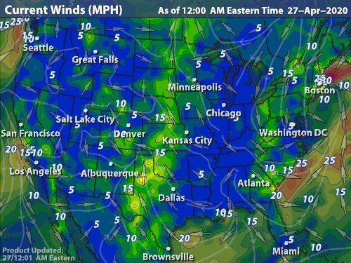
dang stove that wind map is boss

Reb- Admin
- Posts : 745
Join date : 2011-12-05
Location : Maryville, TN
 Re: May Severe Weather
Severe Thunderstorm Watch has been issued for parts of central/eastern Kentucky until 10 p.m. EDT/9 Central. Extends down to the Tennessee border.

WxFreak- Founding Member
- Posts : 812
Join date : 2012-03-27
Age : 52
Location : East Sevier County, TN
 Re: May Severe Weather
This ridge is absolutley starving tennessee of any organized rain.

Adam2014- Founding Member
- Posts : 1424
Join date : 2011-12-05
Age : 28
Location : Lawrenceburg,TN
 Re: May Severe Weather
Nearest storms are in far northern Kentucky, and a few showers dotting the land in western North Carolina.

WxFreak- Founding Member
- Posts : 812
Join date : 2012-03-27
Age : 52
Location : East Sevier County, TN
 Re: May Severe Weather
Added to my wx fav's. Really awesome. When you zoom in to the east TN valley, you can even see the weak convergence over the mountains that helped generate a few storms over there today. Winds in the valley are mainly from the west or southwest. Winds over and east of the mountains are from the south. Where these meet, you get some convergence and weak uplift.

WxFreak- Founding Member
- Posts : 812
Join date : 2012-03-27
Age : 52
Location : East Sevier County, TN
 Re: May Severe Weather
Not much of interest in the short term. More unseasonable warmth with isolated, terrain induced thunderstorms. By early next week a much needed change to somewhat wetter weather may be in the offing.
MRX long term AFD:
FFC Long term:
MRX long term AFD:
LONG TERM...(THURSDAY THROUGH TUESDAY)...MEDIUM RANGE MODELS ARE IN DECENT AGREEMENT WITH BREAKING DOWN THE RIDGE OVER THE TENNESSEE VALLEY ENOUGH TO INTRODUCE SLIGHT CHANCE/CHANCE POPS FOR THURSDAY AND FRIDAY. MAIN FORCING WILL BE OROGRAPHIC...SO GREATEST POPS WILL BE ACROSS THE HIGHER TERRAIN. FOR SATURDAY AND SUNDAY...A WEAK COLD FRONT WILL APPROACH THE AREA KEEPING A CHANCE OF MAINLY AFTERNOON AND EVENING CONVECTION GOING. AGAIN...THE HIGHER CHANCES OVER THE TERRAIN FEATURES.
FOR EARLY NEXT WEEK...A SHORT-WAVE MOVES ACROSS THE PLAIN STATES INTO THE OHIO VALLEY/SOUTHERN GREAT LAKES REGION PULLING FRONT BACK NORTH OVER THE AREA MONDAY WITH ANOTHER FRONT MOVING INTO THE REGION FOR TUESDAY. WILL NEED TO WATCH FOR THE POTENTIAL OF MORE ORGANIZED SEVERE WEATHER FOR TUESDAY AS FRONT MOVES INTO THE FORECAST AREA.
FFC Long term:
LONG TERM /THURSDAY NIGHT THROUGH TUESDAY/...
LONG TERM PERIOD BEGINS WITH REMNANTS OF GULF COAST UPPER SHORT WAVE DRIFTING EASTWARD ACROSS GEORGIA THURSDAY NIGHT INTO FRIDAY AND THEN OFF THE ATLANTIC COAST. CONSENSUS IS THAT GFS IS AFFECTED BY TOO MUCH FEEDBACK...SO HAVE KEPT ONLY SLIGHT CHANCE POPS ACROSS THE CWA THROUGH THE END OF THE WEEK. UPPER RIDGE THEN DRIFTS ENOUGH WESTWARD SO THAT THE STATE IS UNDER A GENERAL NORTHWEST FLOW ALOFT WITH SEVERAL SHORT WAVES MOVING SOUTHEAST TOWARD THE AREA. TIMING AND LOCATION OF ANY OF THESE IS UNCERTAIN SO A LOW CHANCE OR SLIGHT CHANCE LOOKS REASONABLE THROUGH THE WEEKEND. BY THE BEGINNING OF NEXT WEEK THE RIDGE FLATTENS A BIT AS A FRONTAL BOUNDARY BEGINS TO PUSH SOUTHWARD THROUGH THE OHIO VALLEY. SO CHANCE OR SLIGHT CHANCE POPS CONTINUED INTO TUESDAY.

WxFreak- Founding Member
- Posts : 812
Join date : 2012-03-27
Age : 52
Location : East Sevier County, TN
 Re: May Severe Weather
Been looking at the models, it looks like just maybe the ridge breaks down a tad. We won't totally get rid of it because it is summertime. But it might just break down.

Adam2014- Founding Member
- Posts : 1424
Join date : 2011-12-05
Age : 28
Location : Lawrenceburg,TN
 Re: May Severe Weather
By day 7, surface wx maps show a back door front pushing down the East Coast, and another one impinging upon the lower Mississippi Valley region. Looks like our high gets a squeeze play from both sides. Hopefully, that will at least give us a better chance of daily thunderstorms, and some cooling. Both would be welcome.

WxFreak- Founding Member
- Posts : 812
Join date : 2012-03-27
Age : 52
Location : East Sevier County, TN
 Re: May Severe Weather
WxFreak wrote:
Added to my wx fav's. Really awesome. When you zoom in to the east TN valley, you can even see the weak convergence over the mountains that helped generate a few storms over there today. Winds in the valley are mainly from the west or southwest. Winds over and east of the mountains are from the south. Where these meet, you get some convergence and weak uplift.
My only qualm with that map is the lack of county boundaries for reference. But otherwise, very cool.
 Re: May Severe Weather
At the very least, state boundaries would be helpful. The only points of reference when you zoom in are the larger cities.
Since this is “real” time, it is very helpful to observe small scale boundaries that could possibly generate summer convection. Yesterday, you could clearly see why no storms were developing in the Great Valley. A weak westerly flow downsloping off the Plateau would not be conducive for storms here, without something to create uplift—like a LP, or front. However, east of us in North Carolina where our west winds converged with south winds, a few storms did manage to pop without the aid of large scale lift.
Ok, I’m officially geeking out now. Time to stop.
Since this is “real” time, it is very helpful to observe small scale boundaries that could possibly generate summer convection. Yesterday, you could clearly see why no storms were developing in the Great Valley. A weak westerly flow downsloping off the Plateau would not be conducive for storms here, without something to create uplift—like a LP, or front. However, east of us in North Carolina where our west winds converged with south winds, a few storms did manage to pop without the aid of large scale lift.
Ok, I’m officially geeking out now.

WxFreak- Founding Member
- Posts : 812
Join date : 2012-03-27
Age : 52
Location : East Sevier County, TN
 Re: May Severe Weather
WxFreak wrote:At the very least, state boundaries would be helpful. The only points of reference when you zoom in are the larger cities.
Since this is “real” time, it is very helpful to observe small scale boundaries that could possibly generate summer convection. Yesterday, you could clearly see why no storms were developing in the Great Valley. A weak westerly flow downsloping off the Plateau would not be conducive for storms here, without something to create uplift—like a LP, or front. However, east of us in North Carolina where our west winds converged with south winds, a few storms did manage to pop without the aid of large scale lift.
Ok, I’m officially geeking out now.Time to stop.

You should geek out more often, I found that very interesting!
 Re: May Severe Weather
Might get interesting this evening/tonight:
AREA FORECAST DISCUSSION...UPDATED
NATIONAL WEATHER SERVICE MORRISTOWN TN
1025 AM EDT FRI MAY 4 2012
.DISCUSSION...A SHORT-WAVE IS MOVING NORTHEAST ACROSS SOUTHWEST VIRGINIA AND NORTHEAST TENNESSEE WITH WATER VAPOR SHOWING WELL DEFINED DRY BEHIND THE WAVE. THIS DRYING WILL ALLOW SKIES TO BECOME PARTLY CLOUDY AREA-WIDE. AIRMASS WILL ONCE AGAIN DESTABLIZE OVER THE AREA WITH PLENTY OF MOISTURE AND TEMPERATURES WARMING INTO THE 80S. CAPE WILL INCREASE TO 2000-2500 J/KG LATE TODAY AND EARLY TONIGHT.
LATEST NAM CONTINUES TO SUGGEST AN MCS WILL MOVE SOUTHEAST INTO THE AREA OVERNIGHT. MAY NEED TO INCREASE POPS FOR TONIGHT DURING THE AFTERNOON PACKAGE. SOME OF THESE STORMS COULD BE SEVERE WITH DAMAGING WINDS AND LARGE HAIL. WILL UPDATE HWO TO REFLECT THIS THINKING.

WxFreak- Founding Member
- Posts : 812
Join date : 2012-03-27
Age : 52
Location : East Sevier County, TN
 Re: May Severe Weather
Sky has cleared now, but I already notice some large, puffy cumulus towers going up. I think today will be more active than yesterday. Cap should erode as the day wears on. Dewpoints are in the 60's (plenty of moisture available). And according to JKL, convective temps are only in the mid 70's. Won't take long to get there.

WxFreak- Founding Member
- Posts : 812
Join date : 2012-03-27
Age : 52
Location : East Sevier County, TN
 Re: May Severe Weather
Spotty storms already trying to build over Monroe co
tellicowx- Member
- Posts : 4
Join date : 2012-03-27
Age : 46
Location : Tellico Plains
 Re: May Severe Weather
Cumulus humilis building into congestus (towering cumulus). Showing signs of strong vertical development. Showers/storms will be popping soon. As tellicowx stated, a few T-showers already starting to show on radar down in Monroe Co area.

WxFreak- Founding Member
- Posts : 812
Join date : 2012-03-27
Age : 52
Location : East Sevier County, TN
 Re: May Severe Weather
NATIONAL WEATHER SERVICE MORRISTOWN TN
123 PM EDT FRI MAY 4 2012
.AVIATION...MARGINAL MVFR CONDITIONS AT CHA DUE TO CEILING NEAR 2500 FEET WILL LIFT TO 4KFT THIS AFTERNOON. OTHERWISE...VFR CONDITIONS WILL BE THE RULE UNTIL AROUND 03Z OVERNIGHT. A DEVELOPING THUNDERSTORM COMPLEX IS EXPECTED TO DEVELOP OVER THE SOUTHERN OHIO VALLEY...THEN MOVE EAST SOUTHEAST INTO EAST TENNESSEE OVERNIGHT. TRI AND TYS WILL LIKELY SEE CONVECTIVE ACTIVITY BETWEEN 04-09Z. SOME OF THESE STORMS COULD BE STRONG PRODUCING STRONG GUSTY WINDS AND HAIL. THE CHANCE OF SHOWERS AND THUNDERSTORMS WILL CONTINUE THROUGH 18Z SATURDAY.

WxFreak- Founding Member
- Posts : 812
Join date : 2012-03-27
Age : 52
Location : East Sevier County, TN
 Re: May Severe Weather
WxFreak wrote:NATIONAL WEATHER SERVICE MORRISTOWN TN
123 PM EDT FRI MAY 4 2012
.AVIATION...MARGINAL MVFR CONDITIONS AT CHA DUE TO CEILING NEAR 2500 FEET WILL LIFT TO 4KFT THIS AFTERNOON. OTHERWISE...VFR CONDITIONS WILL BE THE RULE UNTIL AROUND 03Z OVERNIGHT. A DEVELOPING THUNDERSTORM COMPLEX IS EXPECTED TO DEVELOP OVER THE SOUTHERN OHIO VALLEY...THEN MOVE EAST SOUTHEAST INTO EAST TENNESSEE OVERNIGHT. TRI AND TYS WILL LIKELY SEE CONVECTIVE ACTIVITY BETWEEN 04-09Z. SOME OF THESE STORMS COULD BE STRONG PRODUCING STRONG GUSTY WINDS AND HAIL. THE CHANCE OF SHOWERS AND THUNDERSTORMS WILL CONTINUE THROUGH 18Z SATURDAY.

 Re: May Severe Weather
PER LMK: Looks like a mid-level cap causing problems for our convection this afternoon. I guess that's why the building cumulus are only getting so high before spreading out at the top.
I wonder how this will play into tonight's storms?
Forecast Update...
Issued at 100 PM EDT Fri May 4 2012
Biggest challenge the next several hours will be convective
potential. We are starting to get enough sunshine to destabilize the
low levels, but there remains a strong mid-level cap. Based on
forecast soundings it looks like we will need to reach at least
82-84F to bust through it. Still expecting scattered convection to
develop by mid-afternoon, and there is plenty of instability and
just enough shear to support a wind threat. Best and earliest shot
at storms, and best chance for any severe weather, will be near the
I-64 corridor.
I wonder how this will play into tonight's storms?

WxFreak- Founding Member
- Posts : 812
Join date : 2012-03-27
Age : 52
Location : East Sevier County, TN
 Re: May Severe Weather
AREA FORECAST DISCUSSION
NATIONAL WEATHER SERVICE MORRISTOWN TN
335 PM EDT FRI MAY 4 2012
.SHORT TERM...(TONIGHT THROUGH SATURDAY NIGHT)...A COMPLEX OF STORMS MOVING ACROSS SOUTHERN INDIANA WILL MOVE EAST-SOUTHEAST TOWARD SOUTHWEST VIRGINIA AND NORTHERN TENNESSEE. THIS AREA IS ASSOCIATED
WITH A MCV FROM LAST NIGHTS CONVECTION. THE LINE OF THUNDERSTORMS WILL MOVE INTO THE FORECAST AREA BETWEEN 23Z-01Z THIS EVENING. OUTFLOW BOUNDARIES FROM THIS CONVECTION WILL LIKELY PRODUCE
ADDITIONAL STORMS OVER THE AREA TONIGHT WITH THE BEST COVERAGE ALONG AND NORTH OF INTERSTATE 40. DECENT INSTABILITY AHEAD OF THIS LINE WITH THERMODYNAMICS SUPPORTIVE OF DAMAGING DOWNBURSTS WINDS.
ISOLATED HAIL THREAT AS WELL.
FOR SATURDAY...PLENTY OF LEFT-OVER BOUNDARIES AND APPROACHING FRONT WILL REMAIN SUPPORTIVE OF SCATTERED CONVECTION. WENT FOR CHANCE POPS AREA-WIDE...BUT MAY NEED TO UP POPS LATER DEPENDING ON EVOLUTION OF OVERNIGHT SYSTEM....

WxFreak- Founding Member
- Posts : 812
Join date : 2012-03-27
Age : 52
Location : East Sevier County, TN
 Re: May Severe Weather
Just glancing at the 12z GFS, it looks like the time around the 15th maybe interesting for parts of the SE including Middle TN and possibly East Tn. Just my opinion tho.
tellicowx- Member
- Posts : 4
Join date : 2012-03-27
Age : 46
Location : Tellico Plains
 Re: May Severe Weather
tellicowx wrote:Just glancing at the 12z GFS, it looks like the time around the 15th maybe interesting for parts of the SE including Middle TN and possibly East Tn. Just my opinion tho.
Agreed...that LPS could certainly spell some trouble and the general track would be very conducive also
 Re: May Severe Weather
Incredible shot of Lightning closeup...stolen from Edward Payne Photography FB page


 Re: May Severe Weather
I am stealing this hard core lol.Toot wrote:Incredible shot of Lightning closeup...stolen from Edward Payne Photography FB page
Last edited by Toot on 2012-05-04, 8:04 pm; edited 1 time in total (Reason for editing : Picture Nazi on patrol)

Adam2014- Founding Member
- Posts : 1424
Join date : 2011-12-05
Age : 28
Location : Lawrenceburg,TN
 Re: May Severe Weather
Looks like our overnight convection may be a bust. Radar very unimpressive. And now MRX says:
NATIONAL WEATHER SERVICE MORRISTOWN TN
747 PM EDT FRI MAY 4 2012
.AVIATION...18Z MODEL SOUNDINGS DID NOT UPSET. THEY REVEALED A LAYER OF WARM AIR AROUND 700 MB WHICH DID NOT BODE WELL FOR THE NORTHERN KENTUCKY BOW ECHO. IT APPEARS THIS LAYER IS DECIMATING POSSIBILITIES FOR ANY WIDESPREAD CONVECTIVE EPISODE ACROSS SOUTHWEST VIRGINIA/NORTHEAST TENNESSEE LATER THIS EVENING WHICH WOULD IMPACT TRI. PLACED A VICINITY SHRA HERE AROUND 05Z WITH A PERIOD OF VFR VSBY REDUCTION IN -SHRA AND BR. SOME OF THIS ACTION MAY PRODUCE A LIGHT SHOWER IN THE VICINITY OF TYS BY 10Z SO INCLUDED HERE. WENT AHEAD AND ADDED VCTS FOR POSSIBLE SCATTERED CONVECTION LATER IN THE AFTERNOON AT EACH OF THE TERMINALS.

WxFreak- Founding Member
- Posts : 812
Join date : 2012-03-27
Age : 52
Location : East Sevier County, TN
Page 16 of 20 •  1 ... 9 ... 15, 16, 17, 18, 19, 20
 Similar topics
» Oct. 17/18 Severe Weather Thread
» Fall Severe Weather Thread
» June 3rd/4th severe weather possibilities.
» TODAY (MARCH 31) SEVERE WEATHER....
» severe weather december 10th 11th
» Fall Severe Weather Thread
» June 3rd/4th severe weather possibilities.
» TODAY (MARCH 31) SEVERE WEATHER....
» severe weather december 10th 11th
Page 16 of 20
Permissions in this forum:
You cannot reply to topics in this forum

