


June 3rd/4th severe weather possibilities.
Page 4 of 6 •  1, 2, 3, 4, 5, 6
 ![]()
Re: June 3rd/4th severe weather possibilities.
![]() by Adam2014 2012-05-29, 10:07 am
by Adam2014 2012-05-29, 10:07 am
 [/img] Here is the 500 MB Bulk shear for Thursday's system, There is a Bullseye of 50 Kts of shear in Northern Mississippi.
Adam2014- Founding Member
- Posts : 1424
Join date : 2011-12-05
Age : 28
Location : Lawrenceburg,TN
Re: June 3rd/4th severe weather possibilities.
![]() by Eric 2012-05-29, 10:14 am
by Eric 2012-05-29, 10:14 am

The western 2/3rds of the state has already seen the frontal passage. Here's a view of the system as the front is approaching the Mississippi River...

Once the ULL migrates northeastward, the winds pick up due to atmospheric pressure differential.
Eric- Severe Wx Specialist
- Posts : 100
Join date : 2012-02-19
Re: June 3rd/4th severe weather possibilities.
![]() by Adam2014 2012-05-29, 10:16 am
by Adam2014 2012-05-29, 10:16 am
Adam2014- Founding Member
- Posts : 1424
Join date : 2011-12-05
Age : 28
Location : Lawrenceburg,TN
Re: June 3rd/4th severe weather possibilities.
![]() by Eric 2012-05-29, 10:18 am
by Eric 2012-05-29, 10:18 am
Adam2014 wrote:I see, there is hardly any shear at the surface even with the surface low northeast.
Here's the 0-6km bulk shear product for hour 78 as the front reaches the Mississippi:

Hardly any shear out ahead of the front. Just one of the issues I personally have with the system...
Eric- Severe Wx Specialist
- Posts : 100
Join date : 2012-02-19
Re: June 3rd/4th severe weather possibilities.
![]() by Adam2014 2012-05-29, 10:20 am
by Adam2014 2012-05-29, 10:20 am
Adam2014- Founding Member
- Posts : 1424
Join date : 2011-12-05
Age : 28
Location : Lawrenceburg,TN
Re: June 3rd/4th severe weather possibilities.
![]() by Eric 2012-05-29, 10:21 am
by Eric 2012-05-29, 10:21 am
Adam2014 wrote:Yeah not much, right now it looks like if there are some storms to develop out in front of the frontal boundry. They could have some short lived rotation and possibly drop a weak tornado.
If...and that's a huge if given the progged temperature inversions at the surface...any discrete cells form ahead of the cold front, those could definitely pose a tornadic threat, but again, I have my doubts.
Eric- Severe Wx Specialist
- Posts : 100
Join date : 2012-02-19
Re: June 3rd/4th severe weather possibilities.
![]() by Adam2014 2012-05-29, 10:23 am
by Adam2014 2012-05-29, 10:23 am
Adam2014- Founding Member
- Posts : 1424
Join date : 2011-12-05
Age : 28
Location : Lawrenceburg,TN
Re: June 3rd/4th severe weather possibilities.
![]() by Adam2014 2012-05-29, 1:52 pm
by Adam2014 2012-05-29, 1:52 pm
 [/img] This is the NAM at hour 66 and the 500 MB Bulk Shear. I can not find the 0-6 KM shear so I will post this. There is just not any shear ahead of the front at all. This is why I think that the storms that form out ahead of the front, if there are any will go linear very soon.
Adam2014- Founding Member
- Posts : 1424
Join date : 2011-12-05
Age : 28
Location : Lawrenceburg,TN
Re: June 3rd/4th severe weather possibilities.
![]() by Eric 2012-05-29, 2:37 pm
by Eric 2012-05-29, 2:37 pm
Eric- Severe Wx Specialist
- Posts : 100
Join date : 2012-02-19
Re: June 3rd/4th severe weather possibilities.
![]() by Adam2014 2012-05-29, 3:35 pm
by Adam2014 2012-05-29, 3:35 pm
Adam2014- Founding Member
- Posts : 1424
Join date : 2011-12-05
Age : 28
Location : Lawrenceburg,TN
Re: June 3rd/4th severe weather possibilities.
![]() by Eric 2012-05-29, 3:47 pm
by Eric 2012-05-29, 3:47 pm
Adam2014 wrote:So is it best to move down the system elevation wise towards the surface or farther up.
There's no right way or wrong way, IMO. Personally, I start at 500mb, jump to 300mb to look at the UL wind pattern, then down to 10m to look at the surface low pressures. After I get a good idea of what the synoptics are progged to look like, I jump into thermodynamics, shear values, skew-Ts, etc. If two of the first three (500mb, 300mb, surface) look like bunk, my optimism for organized severe wx starts to wane. In the same vein, though, someone else could look at my way and think it's dead wrong. That's just how I'm comfortable doing it, because that's the way I learned.
Eric- Severe Wx Specialist
- Posts : 100
Join date : 2012-02-19
Re: June 3rd/4th severe weather possibilities.
![]() by Adam2014 2012-05-29, 3:50 pm
by Adam2014 2012-05-29, 3:50 pm
Adam2014- Founding Member
- Posts : 1424
Join date : 2011-12-05
Age : 28
Location : Lawrenceburg,TN
Re: June 3rd/4th severe weather possibilities.
![]() by Eric 2012-05-29, 3:51 pm
by Eric 2012-05-29, 3:51 pm
Adam2014 wrote:Well thank you for all your tips eric, I am trying to learn how to read all of the upper air perameters.
It takes time and patience...but you'll get there.
Eric- Severe Wx Specialist
- Posts : 100
Join date : 2012-02-19
Re: June 3rd/4th severe weather possibilities.
![]() by Adam2014 2012-05-29, 4:51 pm
by Adam2014 2012-05-29, 4:51 pm
Thank you once again eric!Eric wrote:Adam2014 wrote:Well thank you for all your tips eric, I am trying to learn how to read all of the upper air perameters.
It takes time and patience...but you'll get there.
Adam2014- Founding Member
- Posts : 1424
Join date : 2011-12-05
Age : 28
Location : Lawrenceburg,TN
Re: June 3rd/4th severe weather possibilities.
![]() by Toot 2012-05-29, 5:02 pm
by Toot 2012-05-29, 5:02 pm
Day 4-8
ZCZC SPCSWOD48 ALL
ACUS48 KWNS 290850
SPC AC 290850
DAY 4-8 CONVECTIVE OUTLOOK
NWS STORM PREDICTION CENTER NORMAN OK
0350 AM CDT TUE MAY 29 2012
VALID 011200Z - 061200Z
...DISCUSSION...
MEDIUM RANGE GUIDANCE IS GENERALLY SUGGESTIVE OF AN
EAST-NORTHEASTWARD SHIFTING UPPER TROUGH OVER THE MIDWEST/GREAT
LAKES REGION AND NORTHEAST STATES DURING THE FIRST TWO DAYS OF
JUNE...WITH A RELATIVELY LOW AMPLITUDE BELT OF WESTERLIES OTHERWISE
OVER THE NORTHERN THIRD OF THE CONUS.
NUMERICAL GUIDANCE VARIABILITY/UNCERTAINTIES CONTINUE TO PRECLUDE A
SPECIFIC DELINEATION OF 30 PERCENT CALIBER SEVERE RISKS...ALTHOUGH
SEVERE TSTMS CAN NONETHELESS BE EXPECTED...POTENTIALLY EVEN ON A
WIDESPREAD BASIS ACROSS THE EASTERN CONUS ON DAY 4/FRIDAY. ON
FRIDAY...SEVERE TSTMS SEEM LIKELY WITHIN A GENERAL CORRIDOR FROM THE
TN VALLEY/SOUTHEAST STATES TO THE APPALACHIANS/CAROLINAS AND PERHAPS
MID-ATLANTIC STATES...WITH 00Z GFS-BASED GUIDANCE GENERALLY
SLOWER/FARTHER WEST AS COMPARED TO THE FASTER/FARTHER EAST 00Z
ECMWF. A SEVERE THREAT COULD EVEN LINGER INTO DAY 5/SATURDAY FOR
AREAS SUCH AS THE MID-ATLANTIC COAST/COASTAL CAROLINAS SHOULD A
SLOWER TROUGH/COLD FRONT SOLUTION MATERIALIZE AS PER 00Z
DETERMINISTIC GFS/GEFS GUIDANCE.
THEREAFTER...INDICATIONS ARE THAT SEVERE TSTM POTENTIAL COULD
INCREASE...AT LEAST ON AN ISOLATED BASIS...THIS WEEKEND INTO EARLY
NEXT WEEK ACROSS THE NORTH-CENTRAL CONUS. THIS COULD INITIALLY BE
THE CASE ACROSS THE NORTHERN HIGH PLAINS ON DAY 5/SATURDAY...AND
THEN THE UPPER MIDWEST/UPPER MS RIVER VALLEY ON OR AROUND DAYS 6/7
SUNDAY/MONDAY.

Toot- La Vida Loca
- Posts : 6644
Join date : 2011-12-05
Location : Cocke County, TN -

Re: June 3rd/4th severe weather possibilities.
![]() by Toot 2012-05-29, 5:06 pm
by Toot 2012-05-29, 5:06 pm
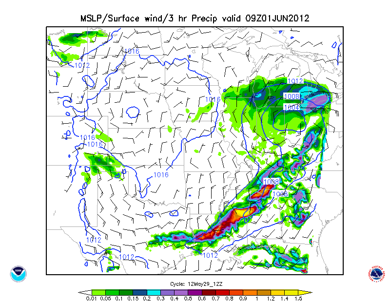
A new severe weather threat emerges in the Great Plains tomorrow, and slowly marches eastward on Thursday and Friday. I have outlined two primary risk zones for Thursday, May 30: discrete cells and bow echo formations in the warm sector of the Ohio and Tennessee Valleys and a probable MCS development in East Texas, including the Arklatex and Houston/Galveston metro. The air mass is forecast to be extremely stable with a high vertical motion banding Thursday evening in the Interstate 10 corridor, so both a heavy rain and microburst scenario may arise in SE TX. I also noticed that the NAM version picks up the Caribbean Sea tropical disturbance as its 500MB trough strengthens going into the Eastern Seaboard on Friday. We will ahve to watch that system for any input toward excessive rainfall chances from Florida northward. Conclusion: the next few days are going to feature a LOT of rough weather from KS/OK/TX to the East Coast, with the northern limit of the big convection just above 40 N Latitude.

12z LSX WRF
SLP and 3hr precip


Last edited by Toot on 2012-05-29, 5:16 pm; edited 1 time in total
Toot- La Vida Loca
- Posts : 6644
Join date : 2011-12-05
Location : Cocke County, TN -
Re: June 3rd/4th severe weather possibilities.
![]() by Adam2014 2012-05-29, 5:19 pm
by Adam2014 2012-05-29, 5:19 pm
 [/img] I am thinking that if any discrete cells form at all that they will be east of I-65 and quickly go into bow echo and linear form which can be just as dangerous.
Adam2014- Founding Member
- Posts : 1424
Join date : 2011-12-05
Age : 28
Location : Lawrenceburg,TN
Re: June 3rd/4th severe weather possibilities.
![]() by Toot 2012-05-29, 5:59 pm
by Toot 2012-05-29, 5:59 pm
Another thing is...one of the the reasons a strong LLJ(850mb) is important is that it can generate large values of helicity that can lead to long lived discrete supercells.
With that said..I think our (TN/OH valley) main tornado threat will be with the warm front where there will be an ample amount of shear. I would also say that there will be some discrete cells out ahead of the cold front that are being fuel'd by the systems dynamics itself.
I dont think this will be a widespread Tornado outbreak but I do think it will be a widespread severe event..with some large hail and winds being the MAIN threat..but I wont rule out the possibilty of a few tornadoes in some of the discrete cells.
Now this is just my opinion based on current model data that could always trend in either direction so take it how you want
Toot- La Vida Loca
- Posts : 6644
Join date : 2011-12-05
Location : Cocke County, TN -
Re: June 3rd/4th severe weather possibilities.
![]() by Toot 2012-05-29, 6:11 pm
by Toot 2012-05-29, 6:11 pm
LOOKING AHEAD TO THURSDAY THROUGH FRIDAY...AN USUALLY DEEP LOW PRESSURE SYSTEM FOR THIS TIME OF YEAR WILL CROSS THE REGION. THUNDERSTORMS WILL BECOME LIKELY...ESPECIALLY THURSDAY NIGHT. SPC HAS THE AREA IN A SLIGHT RISK WITH THE MAIN CONCERNS BEING DAMAGING WINDS AND LARGE HAIL. HEAVY DOWNPOURS SHOULD ALSO BE EXPECTED. WE WILL HAVE TO WAIT AND SEE HOW ALL THE INGREDIENTS COME TOGETHER...BUT A SIGNIFICANT OUTBREAK OF SEVERE STORMS WITH SOME TORNADO POTENTIAL CANNOT BE RULED OUT WITH THIS TYPE OF SYSTEM.
MEG
BY THURSDAY AND THURSDAY NIGHT THE UPPER LOW WILL ROTATE INTO THE MID MISSISSIPPI VALLEY AND THE SURFACE LOW WILL PROBABLY MOVE NORTHEAST ACROSS NORTHERN ARKANSAS INTO THE OHIO VALLEY BY THURSDAY NIGHT. MODELS ARE NOT GREAT AGREEMENT WITH THE TRACK OF THE SURFACE LOW. MEANWHILE THE ASSOCIATED COLD FRONT WILL SWEEP ACROSS THE AREA THURSDAY AND THURSDAY NIGHT. INGREDIENTS ARE IN PLACE FOR AT LEAST SOME SEVERE WEATHER ON THURSDAY THOUGH THE EVENTUAL EVOLUTION DEPENDS GREATLY ON THE IMPACTS FROM ONGOING CONVECTION LATE WEDNESDAY NIGHT/EARLY THURSDAY. AT THIS TIME IT LOOKS LIKE THE AIRMASS WILL BECOME QUITE UNSTABLE BY THURSDAY AFTERNOON WITH LIFTED INDEX VALUES OF -6C TO -8C AND SBCAPES GREATER THAN 2000J/KG. THOUGH WIND FIELDS ARE NOT OVERLY IMPRESSIVE...MID LEVEL WINDS OF 40 KTS PUSHING IN THURSDAY AFTERNOON...THEY SHOULD BE ADEQUATE FOR AT LEAST SOME STORM ORGANIZATION. DAMAGING WINDS AND HAIL ARE THE MAIN THREATS. THE TORNADO THREAT WILL PROBABLY DEPEND ON THE TRACK OF THE SURFACE LOW. THE COLD FRONT WILL PUSH THROUGH THURSDAY EVENING. THE ECMWF IS THE FASTER MODEL THOUGH EITHER WAY ACTIVITY WILL BE OUT OF THE AREA BY FRIDAY MORNING WITH CLEARING SKIES.
Toot- La Vida Loca
- Posts : 6644
Join date : 2011-12-05
Location : Cocke County, TN -
Re: June 3rd/4th severe weather possibilities.
![]() by Adam2014 2012-05-29, 7:00 pm
by Adam2014 2012-05-29, 7:00 pm
Yes toot but I am sure it is much better when you do have the right amount of shear. But like you know you are smarter then me and you have more knowledge about this than me. I am thinking the way you are, widespread wind, hail, and lightning thursday. A few isolated tornadoes possible.Toot wrote:You dont neccesarily have to have the right amount of shear at every single level of the atmosphere to maintain and rotate a thunderstorm cell... and there is more to determining storm mode (if storms will be linear or discrete) than shear anyways.
Another thing is...one of the the reasons a strong LLJ(850mb) is important is that it can generate large values of helicity that can lead to long lived discrete supercells.
With that said..I think our (TN/OH valley) main tornado threat will be with the warm front where there will be an ample amount of shear. I would also say that there will be some discrete cells out ahead of the cold front that are being fuel'd by the systems dynamics itself.
I dont think this will be a widespread Tornado outbreak but I do think it will be a widespread severe event..with some large hail and winds being the MAIN threat..but I wont rule out the possibilty of a few tornadoes in some of the discrete cells.
Now this is just my opinion based on current model data that could always trend in either direction so take it how you want
Adam2014- Founding Member
- Posts : 1424
Join date : 2011-12-05
Age : 28
Location : Lawrenceburg,TN
Re: June 3rd/4th severe weather possibilities.
![]() by Adam2014 2012-05-29, 7:04 pm
by Adam2014 2012-05-29, 7:04 pm
Adam2014- Founding Member
- Posts : 1424
Join date : 2011-12-05
Age : 28
Location : Lawrenceburg,TN
Re: June 3rd/4th severe weather possibilities.
![]() by Toot 2012-05-29, 8:54 pm
by Toot 2012-05-29, 8:54 pm

Toot- La Vida Loca
- Posts : 6644
Join date : 2011-12-05
Location : Cocke County, TN -
Re: June 3rd/4th severe weather possibilities.
![]() by Eric 2012-05-29, 10:24 pm
by Eric 2012-05-29, 10:24 pm
Toot wrote:This EHI graphic is from the 18z NAM at hr 54..this combines instability and Helicity to form hot spots for possible supercells. There are some decent values across the state
Ahh yes....the good ole EHI. Not sure exactly how decent of an indicator it is, though, since at that particular timeframe there is no SLP providing LL convergence, and the mid and upper level trough energy is being displaced further north than previously progged. I don't know...we've all seen events where EHI was thrown around (4/27) and the numbers verified under near-perfect synoptics. Conversely, there's been events where it was thrown around and nothing happened, so it can flow both ways.
Since EHI is a combo of two different atmospheric factors, it's value could be inflated due to either excessive CAPE and/or excessive SRH. Those values on the 18z map could be inflated due to instability values...helicity values look to be quite meager. Those values could get refined with future runs, so taking anything at face value at this point doesn't do much good.
Eric- Severe Wx Specialist
- Posts : 100
Join date : 2012-02-19
Re: June 3rd/4th severe weather possibilities.
![]() by Toot 2012-05-29, 10:59 pm
by Toot 2012-05-29, 10:59 pm
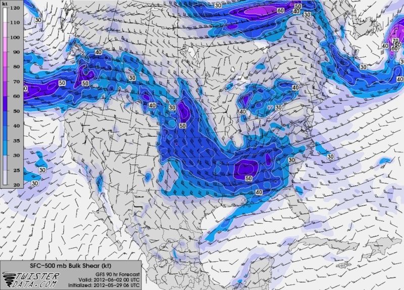
But if it makes you or anyone else feel better... there is more impressive value's of EHI on the 0z Nam run. And it actually has a REAL surface cyclone providing LL Convergence. There is also quite a bit more SFC-500mb bulk shear available too.
But im sure its not enough to make you happy

Toot- La Vida Loca
- Posts : 6644
Join date : 2011-12-05
Location : Cocke County, TN -
Re: June 3rd/4th severe weather possibilities.
![]() by Eric 2012-05-29, 11:13 pm
by Eric 2012-05-29, 11:13 pm
Toot wrote:I would have to agree with you on all points there Eric..lol
But if it makes you or anyone else feel better... there is more impressive value's of EHI on the 0z Nam run. And it actually has a REAL surface cyclone providing LL Convergence. There is also quite a bit more SFC-500mb bulk shear available too.
But im sure its not enough to make you happy
I have no idea....but I'll certainly let you know tomorrow.

Eric- Severe Wx Specialist
- Posts : 100
Join date : 2012-02-19
Page 4 of 6 • 1, 2, 3, 4, 5, 6 ![]()
» May Severe Weather
» Oct. 17/18 Severe Weather Thread
» Fall Severe Weather Thread
» TODAY (MARCH 31) SEVERE WEATHER....


