


Quick shot of snow and Arctic Outbreak coming
Page 7 of 11 •  1, 2, 3 ... 6, 7, 8, 9, 10, 11
 ![]()
Re: Quick shot of snow and Arctic Outbreak coming
![]() by Toot 2011-12-31, 8:28 pm
by Toot 2011-12-31, 8:28 pm


Toot- La Vida Loca
- Posts : 6644
Join date : 2011-12-05
Location : Cocke County, TN -


Reb- Admin
- Posts : 745
Join date : 2011-12-05
Location : Maryville, TN
Re: Quick shot of snow and Arctic Outbreak coming
![]() by Toot 2011-12-31, 8:48 pm
by Toot 2011-12-31, 8:48 pm
Toot- La Vida Loca
- Posts : 6644
Join date : 2011-12-05
Location : Cocke County, TN -
Re: Quick shot of snow and Arctic Outbreak coming
![]() by John1122 2012-01-01, 4:26 am
by John1122 2012-01-01, 4:26 am
Monday: A chance of flurries. Increasing clouds, with a high near 33. Breezy, with a west wind between 10 and 20 mph, with gusts as high as 30 mph.
Monday Night: Snow showers likely before 1am. Mostly cloudy, with a low around 15. Northwest wind around 15 mph, with gusts as high as 25 mph. Chance of precipitation is 60%.
Tuesday: Mostly sunny, with a high near 25. Northwest wind around 10 mph.
Tuesday Night: Mostly clear, with a low around 14.
John1122- Winter Specialist
- Posts : 885
Join date : 2011-12-06
Location : Campbell Co
Re: Quick shot of snow and Arctic Outbreak coming
![]() by Jed33 2012-01-01, 9:03 am
by Jed33 2012-01-01, 9:03 am
Jed33- Admin
- Posts : 930
Join date : 2011-12-09
Location : Morristown, TN
Re: Quick shot of snow and Arctic Outbreak coming
![]() by Adam2014 2012-01-01, 9:27 am
by Adam2014 2012-01-01, 9:27 am
There is a little more moisture, but your tempture should rise some anyways.Jed33 wrote:Guys, is it just me, or does it seem like there is more moisture with this first frontal passage than was predicted last night. I woke up to a downpour that lasted almost 10 minutes, temp was 37 too, oh so close even this morning. Anyway, the radar is filling in around middle tn extending back into ms and al too it looks like. When I went to bed last night I had a 10% chance of precip for today and now this. Mrx says 30% now. Just wondering if this iincrease in moisture today (i.e. More than originally thought would be the case today) will have implications for tomorrows front. Maybe more moisture than modeled.

Adam2014- Founding Member
- Posts : 1424
Join date : 2011-12-05
Age : 28
Location : Lawrenceburg,TN
Re: Quick shot of snow and Arctic Outbreak coming
![]() by Toot 2012-01-01, 10:21 am
by Toot 2012-01-01, 10:21 am
URGENT - WINTER WEATHER MESSAGE...UPDATED
NATIONAL WEATHER SERVICE JACKSON KY
425 AM EST SUN JAN 1 2012
...ACCUMULATING SNOW SHOWERS EXPECTED FROM MONDAY AFTERNOON THROUGH
MONDAY NIGHT...
.A WEATHER DISTURBANCE WILL DROP THROUGH EAST KENTUCKY ON MONDAY AND
BRING WITH IT A PERIOD OF SNOW SHOWERS. THE SNOW IS EXPECTED TO
ACCUMULATE IN THE HIGHER TERRAIN OF FAR EAST KENTUCKY WITH UP TO
A FLUFFY THREE INCHES POSSIBLE BY TUESDAY MORNING ON THE HIGHEST
PEAKS NEAR THE VIRGINIA BORDER. WHILE THE HIGHER SNOW TOTALS WILL
OCCUR ON THE RIDGES...EVEN THE VALLEYS SHOULD SEE AT LEAST AN INCH OF
SNOW BY TUESDAY MORNING. THE SNOW WILL BE ACCOMPANIED BY BRISK WEST
TO NORTHWEST WINDS.
Toot- La Vida Loca
- Posts : 6644
Join date : 2011-12-05
Location : Cocke County, TN -
Re: Quick shot of snow and Arctic Outbreak coming
![]() by Toot 2012-01-01, 10:49 am
by Toot 2012-01-01, 10:49 am
Monday 1pm

Monday at 10pm

Low temp Tuesday AM
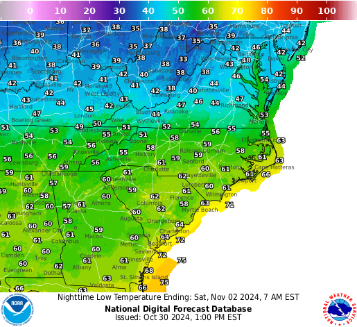
I think northern areas of east TN could see some accumulations with possible dustings as far south as Maryville.
I may even do a call map...not decided yet
Toot- La Vida Loca
- Posts : 6644
Join date : 2011-12-05
Location : Cocke County, TN -
Re: Quick shot of snow and Arctic Outbreak coming
![]() by Adam2014 2012-01-01, 11:34 am
by Adam2014 2012-01-01, 11:34 am
Adam2014- Founding Member
- Posts : 1424
Join date : 2011-12-05
Age : 28
Location : Lawrenceburg,TN
Re: Quick shot of snow and Arctic Outbreak coming
![]() by tennessee storm09 2012-01-01, 11:50 am
by tennessee storm09 2012-01-01, 11:50 am
the trough set up is to far east for us adam, to do us any good. we may get 2 cold days out of it. monday, tueasday.Adam2014 wrote:Okay Im really getting jealous, dang it I'm going to miss out on some snow. My area will be wasting this cold air.
tennessee storm09- Severe Wx Specialist
- Posts : 1304
Join date : 2011-12-05
Age : 61
Location : jackson,tennessee(home of 3 ef4 tornadoes since 1999)
Re: Quick shot of snow and Arctic Outbreak coming
![]() by Guest 2012-01-01, 12:48 pm
by Guest 2012-01-01, 12:48 pm
Btw, yes there was much more moisture with the cold front passage imo. When coming home from church this morning, there were puddles formed on the roadways as a matter of fact. Actually some very small ponding of water on the backroads.
Guest- Guest
Re: Quick shot of snow and Arctic Outbreak coming
![]() by Math/Met 2012-01-01, 1:54 pm
by Math/Met 2012-01-01, 1:54 pm
Cyclonicjunkie wrote:
I think northern areas of east TN could see some accumulations with possible dustings as far south as Maryville.
I may even do a call map...not decided yet
I agree with that. These situations with very cold temperatures and a northwest flow have been very efficient over the past couple years. It looks like there will be enough moisture to around the 850mb level (which is sufficient for this type of setup) and the northwest flow is strong enough to provide a good upslope flow over the mountains.
In my opinion, the models tend to underestimate the moisture with this type of system. When you consider the high ratios that are possible with these systems, a small amount of moisture can make a significant difference.
This won’t be a major event, but I think even the lower elevations of NE TN have a chance to see some minor accumulations.
Math/Met- Meteorologist
- Posts : 226
Join date : 2011-12-05
Re: Quick shot of snow and Arctic Outbreak coming
![]() by Reb 2012-01-01, 2:03 pm
by Reb 2012-01-01, 2:03 pm
Reb- Admin
- Posts : 745
Join date : 2011-12-05
Location : Maryville, TN
Re: Quick shot of snow and Arctic Outbreak coming
![]() by Math/Met 2012-01-01, 2:06 pm
by Math/Met 2012-01-01, 2:06 pm
I’m not sure how far south it will go. I’m mainly talking about areas farther north and east.Reb wrote:dusting in maryville? nice. im thinking some flurries are possible down here but downsloping will kill a lot of the moisture.
But the good news is, it won’t take too much to get a dusting with temperatures that low.
Math/Met- Meteorologist
- Posts : 226
Join date : 2011-12-05
Re: Quick shot of snow and Arctic Outbreak coming
![]() by snowdog 2012-01-01, 2:11 pm
by snowdog 2012-01-01, 2:11 pm
Adam2014 wrote:Okay Im really getting jealous, dang it I'm going to miss out on some snow. My area will be wasting this cold air.
Patience, patience. Looking at the long range GFS it keeps wanting to show an overrunning event near mid-month in our area.
snowdog- Winter Specialist
- Posts : 855
Join date : 2011-12-14
Age : 46
Location : Mount Juliet, TN
Re: Quick shot of snow and Arctic Outbreak coming
![]() by Math/Met 2012-01-01, 2:22 pm
by Math/Met 2012-01-01, 2:22 pm
Math/Met- Meteorologist
- Posts : 226
Join date : 2011-12-05
Re: Quick shot of snow and Arctic Outbreak coming
![]() by John1122 2012-01-01, 2:43 pm
by John1122 2012-01-01, 2:43 pm
My snow chances have done the following over the past 3 days.
Three days ago Day shift: Sprinkes/nothing.
Nightshift: Flurries/Flurries.
Two days ago day: nothing/flurries.
Nightshift: 20% snow showers/30 percent snow showers.
Yesterday Dayshift: Flurries/Flurries
Nightshift: 20 percent snow showers/30 percent snow showers.
Today:
Nightshift flurries/60 percent snow chance.
Dayshift: 20 percent snow showers/20 percent snow showers.
John1122- Winter Specialist
- Posts : 885
Join date : 2011-12-06
Location : Campbell Co
Re: Quick shot of snow and Arctic Outbreak coming
![]() by John1122 2012-01-01, 3:35 pm
by John1122 2012-01-01, 3:35 pm
Says I might see a dusting as well as the Northern Valley areas.
John1122- Winter Specialist
- Posts : 885
Join date : 2011-12-06
Location : Campbell Co
Re: Quick shot of snow and Arctic Outbreak coming
![]() by Toot 2012-01-01, 4:28 pm
by Toot 2012-01-01, 4:28 pm
Math/Met wrote:
I agree with that. These situations with very cold temperatures and a northwest flow have been very efficient over the past couple years. It looks like there will be enough moisture to around the 850mb level (which is sufficient for this type of setup) and the northwest flow is strong enough to provide a good upslope flow over the mountains.
In my opinion, the models tend to underestimate the moisture with this type of system. When you consider the high ratios that are possible with these systems, a small amount of moisture can make a significant difference.
This won’t be a major event, but I think even the lower elevations of NE TN have a chance to see some minor accumulations.
Agreed... these type of events is how I get most of my yearly snowfall totals...and yep..orographic lift in nearly all of these type of events are underestimated by models and they end up way light on precip amounts asscociated with the NW flow. Places in NE TN could well be in for a nice surprise tomorrow.
Reb wrote:dusting in maryville? nice. im thinking some flurries are possible down here but downsloping will kill a lot of the moisture.
Maryville dont usually do too well in these type of events but i definately wouldnt rule out a light coating due to the frigid surface conditions.
John1122 wrote:MRX has the standard WWA for 1-3 inches of snow above 2500 in the Smokies/SWVA/NE Tennessee mountains.
Says I might see a dusting as well as the Northern Valley areas.
Their WWA is pretty confusing as to who the lower elevations are?
...WINTER WEATHER ADVISORY IN EFFECT FROM 4 PM MONDAY TO NOON EST
TUESDAY...
THE NATIONAL WEATHER SERVICE IN MORRISTOWN HAS ISSUED A WINTER
WEATHER ADVISORY FOR SNOW...WHICH IS IN EFFECT FROM 4 PM MONDAY TO
NOON EST TUESDAY.
* TIMING...SNOW SHOWERS WILL BEGIN MONDAY AFTERNOON AND CONTINUE
THROUGH THE NIGHT...THEN TAPER OFF THROUGH TUESDAY MORNING.
*SNOW ACCUMULATIONS OF 1 TO 2 INCHES ARE EXPECTED IN MOST OF THE
LOWER ELEVATIONS BY TUESDAY MORNING. THE HIGHER
ELEVATIONS...MAINLY AT OR ABOVE 2500 FEET...ARE EXPECTED TO
RECEIVE BETWEEN 2 AND 3 INCHES OF SNOWFALL...WITH UP TO 4 INCHES
POSSIBLE ON THE HIGHEST PEAKS.
* VERY COLD TEMPERATURES AND BRISK NORTHWEST WINDS WILL MAKE FOR
FLUFFY SNOW. THIS WILL ENHANCE TOTAL ACCUMULATIONS...AND ALSO
CAUSE PERIODS OF LOW VISIBILITY DUE TO BLOWING SNOW. SUB-ZERO
WIND CHILL VALUES CAN ALSO BE EXPECTED IN THE MOUNTAINS ON MONDAY
NIGHT.
PRECAUTIONARY/PREPAREDNESS ACTIONS...
A WINTER WEATHER ADVISORY FOR SNOW MEANS THAT PERIODS OF SNOW ARE
EXPECTED OR OCCURRING...BUT ACCUMULATIONS ARE EXPECTED TO BE LIGHT.
DRIVING AND WALKING MAY BE DIFFICULT ON UNTREATED ROADWAYS AND
SIDEWALKS. BE PREPARED FOR SNOW COVERED ROADS AND LIMITED
VISIBILITIES. IF YOU MUST TRAVEL...SLOW DOWN AND ALLOW EXTRA TIME
TO REACH YOUR DESTINATION.
Toot- La Vida Loca
- Posts : 6644
Join date : 2011-12-05
Location : Cocke County, TN -
Re: Quick shot of snow and Arctic Outbreak coming
![]() by John1122 2012-01-01, 4:51 pm
by John1122 2012-01-01, 4:51 pm
John1122- Winter Specialist
- Posts : 885
Join date : 2011-12-06
Location : Campbell Co

Reb- Admin
- Posts : 745
Join date : 2011-12-05
Location : Maryville, TN
Re: Quick shot of snow and Arctic Outbreak coming
![]() by Toot 2012-01-01, 5:17 pm
by Toot 2012-01-01, 5:17 pm
Reb wrote:fellers...
Thats a good sign Reb...these type of events dont show their true colors until nowcasting time...Ive really got a nice feeling about this little event...several little signals point to something more than a few snow showers/flurries...but im not ready to board any trains just yet....let me just say that the nam consistently showing that impressive great lakes moisture fetch is a feature that could lend support to a better event than is currently being advertised.
Toot- La Vida Loca
- Posts : 6644
Join date : 2011-12-05
Location : Cocke County, TN -
Re: Quick shot of snow and Arctic Outbreak coming
![]() by Toot 2012-01-01, 6:23 pm
by Toot 2012-01-01, 6:23 pm
Hot off the press from JKL

AREA FORECAST DISCUSSION
NATIONAL WEATHER SERVICE JACKSON KY
614 PM EST SUN JAN 1 2012
.SHORT TERM.../TONIGHT THROUGH MONDAY NIGHT/
COMPLEX SHORT TERM WEATHER. WINDS CONTINUE TO DIE DOWN...BUT ISOLATED
HIGHER GUSTS ARE STILL OCCURRING. WILL LET CURRENT WIND ADVISORIES
RUN THEIR COURSE.
OTHERWISE ATTENTION TURNS TO SHORT WAVE ENERGY THAT DROPS OUT OF
CANADA AND INTO OUR REGION BY LATE MONDAY AFTERNOON. THIS DISTURBANCE
WILL BE THE MAIN CATALYST FOR SNOW SHOWERS ACROSS EASTERN KENTUCKY
MONDAY AFTERNOON THROUGH TUESDAY MORNING. LOW LEVEL LAPSE RATES ON
NAM/GFS BUFR SOUNDINGS STEEPEN CONSIDERABLY. INTERESTINGLY ENOUGH TQ
INDEX VALUES ALMOST REACH THRESHOLD LEVELS FOR LOW TOP THUNDERSTORM
CELLS AS WELL. THINKING IS THAT THERE COULD BE SOME INTENSE SNOW
SHOWERS WITH THIS SYSTEM...OR EVEN A FEW SNOW SQUALL TYPE SHOWERS.
FAVORABLE UPSLOPE FLOW WILL ONLY HELP ENHANCE ANY SNOW ACCUMULATIONS
BY THE TIME THINGS DIE DOWN TUESDAY MORNING. DECIDED TO EXPAND THE
WINTER WEATHER ADVISORY ONE OR TWO TIERS OF COUNTIES NORTHWARD. MAKE
NOTE THAT BREATHITT...CLAY AND MAGOFFIN COUNTIES WERE INCLUDED MORE
FOR SNOW ACCUMULATIONS IN THE SOUTHERN HALF OF EACH COUNTY...AND KNOX
FOR SNOWFALL IN THE EASTERN PORTIONS OF THE COUNTY. IN GENERAL IT
APPEARS MOST LOCATIONS IN THE ADVISORY WILL SEE AT LEAST AN INCH OF
SNOW...THOUGH GUSTY WINDS WILL MAKE IT LOOK LIKE LESS. THE HIGHER
RIDGES AND ELEVATIONS WILL LIKELY SEE MORE WHERE 1 TO 4 INCHES COULD
BE ON THE GROUND BY THE TIME THE SNOW ENDS ON TUESDAY. OF COURSE
LOCALLY HIGHER AMOUNTS WILL BE POSSIBLE...MOST LIKELY WHERE THE
ACTUAL BANDS SET UP AS DETERMINED BY THE UPSLOPE FLOW. INCREASED POPS
ACCORDINGLY...MUCH HIGHER THAN GUIDANCE SUGGEST AS MODELS ALWAYS DO
POORLY IN THESE SITUATIONS. ONLY CONCERN IS THAT THE GFS STILL HINTS
AT LIMITED BOUNDARY LAYER MOISTURE. BUT THE NAM HAS BEEN CONSISTENT
IN SHOWING MORE MOISTURE. THINKING WAS TO FOLLOW THE HIGHER
RESOLUTION NAM AT THIS POINT AND THAT ANY CONVECTION WOULD MAKE UP
FOR THE LACK OF MOISTURE SHOULD THE NAM BE OFF.
NOT MUCH CHANGE TO THE TEMPS. COLDEST AIR OF THE SEASON WILL GIVE A
OUR FIRST TASTE OF REAL WINTER...WITH WIND CHILLS DROPPING INTO THE
SINGLE DIGITS MONDAY NIGHT INTO TUESDAY. INHERITED TEMPS LOOKED RIGHT
ON TARGET WITH GUIDANCE SO ONLY A FEW TWEAKS WERE MADE IF EVEN THAT.
WINDS WILL CONTINUE TO BE BREEZY AT TIMES AND WILL BE RESPONSIBLE FOR
LOW VISIBILITIES AT TIMES AS WELL AS SOME DRIFTING OF SNOW WHERE SNOW
OCCURS.
Toot- La Vida Loca
- Posts : 6644
Join date : 2011-12-05
Location : Cocke County, TN -
Re: Quick shot of snow and Arctic Outbreak coming
![]() by Toot 2012-01-01, 6:44 pm
by Toot 2012-01-01, 6:44 pm

Toot- La Vida Loca
- Posts : 6644
Join date : 2011-12-05
Location : Cocke County, TN -
Re: Quick shot of snow and Arctic Outbreak coming
![]() by skillsweather 2012-01-01, 7:02 pm
by skillsweather 2012-01-01, 7:02 pm
skillsweather- Banned
- Posts : 313
Join date : 2011-12-06
Age : 32
Location : tennessee Wilson county Ne Corner
Page 7 of 11 • 1, 2, 3 ... 6, 7, 8, 9, 10, 11 ![]()
» Arctic Outbreak Possible (85 style?)
» Low temp contest from the new years arctic outbreak
» Timing the Coming Arctic Cold
» Study: Less Arctic ice means more U.S. snow


