


Winter 2011/2012 Pattern Discussion
Page 17 of 37 •  1 ... 10 ... 16, 17, 18 ... 27 ... 37
 ![]()
Re: Winter 2011/2012 Pattern Discussion
![]() by Stovepipe 2012-01-05, 11:46 am
by Stovepipe 2012-01-05, 11:46 am


Stovepipe- Founding Member
- Posts : 4148
Join date : 2011-12-05
Age : 48
Location : Knoxville, TN -

Re: Winter 2011/2012 Pattern Discussion
![]() by Stovepipe 2012-01-05, 1:15 pm
by Stovepipe 2012-01-05, 1:15 pm
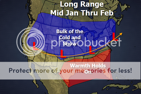
1. I think we are seeing the pattern starting to change, and if you watch the video, I explain in detail what I am looking at in regards to the change.
2. The map below illustrates where I think we will see the cold and snowy weather pattern developing. With the PNA staying negative or near neutral, the cold air will slosh in and managed to spread across the country with a storm track running along the southern edge of the cold air. The South will stay on the warm side as the ridge holds on and the cold air can go only so far.
Stovepipe- Founding Member
- Posts : 4148
Join date : 2011-12-05
Age : 48
Location : Knoxville, TN -
Re: Winter 2011/2012 Pattern Discussion
![]() by tennessee storm09 2012-01-05, 1:34 pm
by tennessee storm09 2012-01-05, 1:34 pm
looks like we are in right down in the middle of the battlezone of cold and warm air. umm could be fun times ahead with all kinds of weather.Stovepipe wrote:AccuWeather's Henry Margusity:
1. I think we are seeing the pattern starting to change, and if you watch the video, I explain in detail what I am looking at in regards to the change.
2. The map below illustrates where I think we will see the cold and snowy weather pattern developing. With the PNA staying negative or near neutral, the cold air will slosh in and managed to spread across the country with a storm track running along the southern edge of the cold air. The South will stay on the warm side as the ridge holds on and the cold air can go only so far.
tennessee storm09- Severe Wx Specialist
- Posts : 1304
Join date : 2011-12-05
Age : 61
Location : jackson,tennessee(home of 3 ef4 tornadoes since 1999)
Re: Winter 2011/2012 Pattern Discussion
![]() by Homemommy 2012-01-05, 5:25 pm
by Homemommy 2012-01-05, 5:25 pm
Of course, ya'll know this. I just thought it was cool he is already talking potential 6-7 days out.

Homemommy- Founding Member
- Posts : 824
Join date : 2011-12-07
Age : 43
Location : Southeast Knox County -
Re: Winter 2011/2012 Pattern Discussion
![]() by tennessee storm09 2012-01-05, 9:39 pm
by tennessee storm09 2012-01-05, 9:39 pm
tennessee storm09- Severe Wx Specialist
- Posts : 1304
Join date : 2011-12-05
Age : 61
Location : jackson,tennessee(home of 3 ef4 tornadoes since 1999)
Re: Winter 2011/2012 Pattern Discussion
![]() by Toot 2012-01-05, 10:48 pm
by Toot 2012-01-05, 10:48 pm

I dont see this pattern changing much unless the trough gets deeper due to the expected downward trend of the NAO.

Toot- La Vida Loca
- Posts : 6644
Join date : 2011-12-05
Location : Cocke County, TN -
Re: Winter 2011/2012 Pattern Discussion
![]() by Stovepipe 2012-01-05, 11:18 pm
by Stovepipe 2012-01-05, 11:18 pm
http://www.examiner.com/weather-in-charlotte/january-pattern-update
Stovepipe- Founding Member
- Posts : 4148
Join date : 2011-12-05
Age : 48
Location : Knoxville, TN -
Re: Winter 2011/2012 Pattern Discussion
![]() by snowdog 2012-01-06, 8:05 am
by snowdog 2012-01-06, 8:05 am
Stovepipe wrote:Brandon Huffman's latest thoughts on the pattern:
http://www.examiner.com/weather-in-charlotte/january-pattern-update
Pretty good write-up. The PDO/PNA part scares me a little bit unless we can lock in a -AO/-NAO.
snowdog- Winter Specialist
- Posts : 855
Join date : 2011-12-14
Age : 46
Location : Mount Juliet, TN
Re: Winter 2011/2012 Pattern Discussion
![]() by Stovepipe 2012-01-06, 9:54 am
by Stovepipe 2012-01-06, 9:54 am
Hints of a pattern change, with an EPO- and AO- are growing on the ECMWF and GFS ensembles and operational models. The PNA could turn somewhat negative, but not so negative that the trough locks into the West initially. One scenario based on historic teleconnection data coupled with ENSO data would be an area of cold anomalies that extends from Alaska/Western Canada through much of the Northern/Central Plains into parts of the Ohio Valley/East (exceptions being northern New England and eastern Canada) for the January 16-23 timeframe as a whole. The farther east one goes, the more moderate the cool anomalies would be. Under such a scenario, ridging would lead to the Southwestern U.S. being warmer than normal (a big change this winter).
A second scenario would keep the East generally mild with transient cold shots during the 1/16-23 timeframe. Cold anomalies would extend from Canada into the Northern Plains, but a more sustained period of cold could be delayed farther east. The 1/6/2012 0z run of the GFS favors this scenario.
Both scenarios keep eastern Canada (Newfoundland, New Brunswick, and Nova Scotia) along with northern New England warmer than normal. Both scenarios also show Alaska and Western Canada having below normal temperatures.
Such a pattern might last 2-3 weeks before the EPO goes positive, PNA- leads to the trough's relocating/locking in the west, and/or another AO+ regime sets in. That doesn't mean that the whole 2-3-week timeframe would wind up colder than normal as a whole in the East/Ohio Valley/southern Canada, but 1 or 2 weeks could wind up colder than normal. If so, there's a chance February could start colder than normal in that region. The ongoing strong PDO- regime suggests that the PNA- will likely lead to the trough's eventually heading west and then locking in there.
While I await more data before committing to either scenario, it should be noted that in a winter where the warmth has found a way to win out, even during the current week that saw winter's strongest shot of cold air delivered to the east, a dose of caution is in order. Hence, the second scenario might be somewhat more likely than the first one.
PDO- winters have a higher frequency of PNA- than PDO+ ones (SSTAs being the driver). MJO can't be forecast that far out. Also the period of blocking that seems to be increasingly likely looks to be the result of the polar vortex's being displaced not split. Normal to somewhat below average Siberian snow cover also argues against an AO- winter. EPO is shown as returning to somewhat positive levels on some of the guidance e.g., 0z GFS ensembles.
Stovepipe- Founding Member
- Posts : 4148
Join date : 2011-12-05
Age : 48
Location : Knoxville, TN -
Re: Winter 2011/2012 Pattern Discussion
![]() by jmundie 2012-01-06, 10:25 am
by jmundie 2012-01-06, 10:25 am
Little back and forth with Justin Bruce from News 2 on twitter this AM. He seems to think this cold shot will be a bit weaker than originally modeled, but will be able to push the vortex further west over the hudson bay, at which point we'll have the right set up to get a big phasing system and a massive cold outbreak.
6z gfs sure was frigid...
jmundie- Winter Specialist
- Posts : 743
Join date : 2011-12-19
Re: Winter 2011/2012 Pattern Discussion
![]() by Stovepipe 2012-01-06, 11:46 am
by Stovepipe 2012-01-06, 11:46 am
whoa boy. Split flow. The Block northslope of Alaska, deep cold pushing out of central Canad and nw flow in the East, witha clipper around day 10 and a new system in split flow coming into southern California, with arctic high ridging a long way out of Northwest Canada to the Ohio Valley. Exciting run and lots of potential with this. The key is the Block that starts around days 7 and 8 , we're inching toward a great pattern i think.
Great pattern coming up, or interesting. The cold is pressing south , all the way from Canada, and once we turn cold in a week, we don't warm much at all, and keep cold coming in with the highs placed to our north and northwest. Best news to me is the undercutting going on in southern California. Classic setup. Verbatim, major NC snowstorm, not quite cold enough further south, but wintry looking from 240 through the end of the run. The pattern looks good to me. Only other way to look better is to build a Greenland block, which may end up being too supressed..but as it is, some folks are going to comine Cold+ Moisture.
This run holds the most promise yet, and fits with how the GFS has been evolving generally since it started sniffing a change at high latitudes. The ridging starts in about a week west of Alaska, grows north, cuts off and then rolls southeast and links up with massive western ridging in western Conus. Meanwhile at that time the flow is so supressed out west that Pacific systems will start to cut under that mega ridge, and slide due east toward western Texas where Gulf low will develop. At that time, thanks to the position of all the features and the cold air, and the surface high placement in Canada and the US, this is a classic setup for overrunning snow , ice and cold rain in the Deep South, Tennessee Valley and MidAtlantic. That's how this run looks, and it fits climo. and teleconnections well. Keep in mind models kill blocks too soon usually. This is still not a given yet, the block or its location, and location will mean everything. Its still also possible the cold dumps totally into the west , and may end up doing that later on. But it does appear our cold will begin in about 7 days.
Stovepipe- Founding Member
- Posts : 4148
Join date : 2011-12-05
Age : 48
Location : Knoxville, TN -
Re: Winter 2011/2012 Pattern Discussion
![]() by Snowmania 2012-01-06, 12:56 pm
by Snowmania 2012-01-06, 12:56 pm
Snowmania- Banned
- Posts : 14
Join date : 2012-01-06
Re: Winter 2011/2012 Pattern Discussion
![]() by Stovepipe 2012-01-06, 1:06 pm
by Stovepipe 2012-01-06, 1:06 pm
Snowmania wrote:Hate to say it but I think this winter will fizzle out like 2008...thats the better year to compare instead of 1985 which is so far fetched at this point that its hard to believe its tossed around as an analogue.
Just curious, what have you seen that would suggest a fizzle? The Euro weeklies?
Welcome to Toot's by the way!
Stovepipe- Founding Member
- Posts : 4148
Join date : 2011-12-05
Age : 48
Location : Knoxville, TN -
Re: Winter 2011/2012 Pattern Discussion
![]() by Guest 2012-01-06, 1:19 pm
by Guest 2012-01-06, 1:19 pm
Welcome to the forum!
Guest- Guest
Re: Winter 2011/2012 Pattern Discussion
![]() by Snowmania 2012-01-06, 1:21 pm
by Snowmania 2012-01-06, 1:21 pm
NAO isnt going in the tank anytime soon. If you notice all the "big pattern changes" are all about 300 hours out...and then they change. It's going to go to mid month, to early feb, ...alot of hope casting.
Not to say plenty of places cant get there avg this year. But is that really a good winter to have 1 late event while the rest of your winter has sucked? 2 days out of 4 months dont make my winter.
Snowmania- Banned
- Posts : 14
Join date : 2012-01-06
Re: Winter 2011/2012 Pattern Discussion
![]() by Snowmania 2012-01-06, 1:25 pm
by Snowmania 2012-01-06, 1:25 pm
http://en.wikipedia.org/wiki/Donald_Sutherland
Snowmania- Banned
- Posts : 14
Join date : 2012-01-06
Toot- La Vida Loca
- Posts : 6644
Join date : 2011-12-05
Location : Cocke County, TN -
Re: Winter 2011/2012 Pattern Discussion
![]() by Homemommy 2012-01-06, 1:30 pm
by Homemommy 2012-01-06, 1:30 pm
Snowmania wrote:I think the more appropriate questions is "what have you seen to suggest a break in the current pattern?"
NAO isnt going in the tank anytime soon. If you notice all the "big pattern changes" are all about 300 hours out...and then they change. It's going to go to mid month, to early feb, ...alot of hope casting.
Not to say plenty of places cant get there avg this year. But is that really a good winter to have 1 late event while the rest of your winter has sucked? 2 days out of 4 months dont make my winter.
Oh, don't give up yet! Granted, this has so far been a horrible winter for everyone, even up in New England. The ski resorts are really having a tough time. But, don't lose heart yet. Winter officially just started a few weeks ago. If I remember correctly, 93 didn't start out so great and you know how that ended.
Glad to have you here.
Homemommy- Founding Member
- Posts : 824
Join date : 2011-12-07
Age : 43
Location : Southeast Knox County -
Re: Winter 2011/2012 Pattern Discussion
![]() by Homemommy 2012-01-06, 1:33 pm
by Homemommy 2012-01-06, 1:33 pm
Snowmania wrote:Tom, thanks alot...but what does donald sutherland (or Keifer for that matter) have to do with this? I saw nothing in his wiki page as suggesting he has a passion for weather:
http://en.wikipedia.org/wiki/Donald_Sutherland
I just have to say...I thought the same thing at first!! But I think there is a poster/met guy that is named Donald Sutherland and they are taking the actor Donald Sutherland's picture and using them together. They really aren't the same person.
Homemommy- Founding Member
- Posts : 824
Join date : 2011-12-07
Age : 43
Location : Southeast Knox County -
Re: Winter 2011/2012 Pattern Discussion
![]() by Snowmania 2012-01-06, 1:40 pm
by Snowmania 2012-01-06, 1:40 pm
I have read this forum before...just a FYI...I consider myself to be a Tom 2.0
Snowmania- Banned
- Posts : 14
Join date : 2012-01-06
Re: Winter 2011/2012 Pattern Discussion
![]() by Homemommy 2012-01-06, 1:43 pm
by Homemommy 2012-01-06, 1:43 pm
Snowmania wrote:I was just pulling tom's leg...
I have read this forum before...just a FYI...I consider myself to be a Tom 2.0
Oh! LOL! I guess the joke's on me then....Man, do I feel stupid.

Homemommy- Founding Member
- Posts : 824
Join date : 2011-12-07
Age : 43
Location : Southeast Knox County -
Re: Winter 2011/2012 Pattern Discussion
![]() by Southeastbutter 2012-01-06, 1:44 pm
by Southeastbutter 2012-01-06, 1:44 pm
Southeastbutter- Banned
- Posts : 33
Join date : 2011-12-14
Re: Winter 2011/2012 Pattern Discussion
![]() by Guest 2012-01-06, 1:44 pm
by Guest 2012-01-06, 1:44 pm
Snowmania wrote:I was just pulling tom's leg...
I have read this forum before...just a FYI...I consider myself to be a Tom 2.0
LOL... its nice to have you here Bro!! Although tom23 2.0 (Idk if you saw that thread or the posts I made as that version) went haywire and was carded, and there are no future expectations for a 3.0 version to be made.
Guest- Guest
Re: Winter 2011/2012 Pattern Discussion
![]() by Snowmania 2012-01-06, 1:50 pm
by Snowmania 2012-01-06, 1:50 pm
So it's off to lunch, I only get about an hour in the yard so I better take advantage of this weather today...and that's why i follow the weather believe it or not. Ok Cheers
Snowmania- Banned
- Posts : 14
Join date : 2012-01-06
Re: Winter 2011/2012 Pattern Discussion
![]() by Guest 2012-01-06, 1:52 pm
by Guest 2012-01-06, 1:52 pm
Snowmania wrote:Actually tom..I am probably more like Tom 3.0 now, as the first Tom at the forum whose name shall never be spoken was more like Tom Vista...a complete disaster.
So it's off to lunch, I only get about an hour in the yard so I better take advantage of this weather today...and that's why i follow the weather believe it or not. Ok Cheers
Tom Vista?? I like it! lol
Guest- Guest
Page 17 of 37 • 1 ... 10 ... 16, 17, 18 ... 27 ... 37 ![]()
» Is winter over? Very weird pattern going on!!
» Winter wx Discussion 2015/16
» Winter Wx Discussion 2013/14
» Winter Wx Discussion 2014/2015


