


Winter 2011/2012 Pattern Discussion
Page 10 of 37 •  1 ... 6 ... 9, 10, 11 ... 23 ... 37
 ![]()
Re: Winter 2011/2012 Pattern Discussion
![]() by Toot 2011-12-23, 3:10 pm
by Toot 2011-12-23, 3:10 pm
Stovepipe wrote: Fascinating stuff and it does appear that change is on the horizon.
Im about ready to make a pattern change forecast...im just trying to pin down some smaller scale details of which storm will usher this in...as of right now I like a strong cold front near New Years Eve... but the possibility of a stronger wave of low pressure forming along that cold front is murking up clarity...will hold off on a forecast until it becomes a little clearer


Toot- La Vida Loca
- Posts : 6644
Join date : 2011-12-05
Location : Cocke County, TN -

Re: Winter 2011/2012 Pattern Discussion
![]() by Stovepipe 2011-12-23, 9:01 pm
by Stovepipe 2011-12-23, 9:01 pm
Recent runs of the GFS have hinted that the first week in January could be colder than normal in the East with perhaps the lowest readings so far this winter. However, that hint of a pattern change to colder weather is likely another false alarm. It does not fit with what would typically be expected given the major teleconnections. The expected pattern from the major teleconnections matches up very well with the latest NAEFS forecast.
The composite temperature anomalies based on ENSO and major teleconnections (Message #287) for January 1-7, 2012 and the NAEFS temperature anomalies forecast for 12/31/2011-1/6/2012 are in strong agreement.
In addition, the 12/23 12z Euro ensembles have widespread warmth on January 1 and 2. At that time, the 18z GFS is indicating a strong shot of cold will cover the East. The 18z run, unlike some preceding runs of the GFS shows the cold shot as transient. That could also be a hint that the GFS will soon be adjusting to a scenario closer to what one might expect given the current pattern.
I was inspired to auto-tune his thoughts:
http://khu.sh/usersong_4ef531c7a0b2e

Stovepipe- Founding Member
- Posts : 4148
Join date : 2011-12-05
Age : 48
Location : Knoxville, TN -
Re: Winter 2011/2012 Pattern Discussion
![]() by Toot 2011-12-23, 9:11 pm
by Toot 2011-12-23, 9:11 pm
 Too damn funny
Toot- La Vida Loca
- Posts : 6644
Join date : 2011-12-05
Location : Cocke County, TN -
Re: Winter 2011/2012 Pattern Discussion
![]() by Toot 2011-12-23, 9:54 pm
by Toot 2011-12-23, 9:54 pm
The gfs ensembles are still saying major pattern change at this point and have not changed one bit... the euro ensembles are saying slight pattern change and have been slightly adjusting towards the gfs ensembles...something between the two seems likely IMO...but we wont know for a few more days which one has the right idea unless one of them caves in to the other.
As far as the 500mb pattern matching the forecasted teleconnection indices...well IMO they do...the GFS ensembles are predicting neutral to slightly positive NAO values ( which will allow for the advertised weak blocking) and Positive PNA values (which will allow for a well amplified ridge out west)....BTW Larry Cosgrove is going Cold east of the Continental divide for January.
Be interesting to see how this turns out...Im leaning towards the GFS ensembles because climo supports them and Climo carries a big stick no matter what model says what

Toot- La Vida Loca
- Posts : 6644
Join date : 2011-12-05
Location : Cocke County, TN -
Re: Winter 2011/2012 Pattern Discussion
![]() by Stovepipe 2011-12-24, 12:24 am
by Stovepipe 2011-12-24, 12:24 am
The analogs were based on the following criteria:
All dates from January 1-10, 1950 through 2011 that:
AO in the +1 to +3 range
PNA in the -0.50 to +0.50 range
ENSO R3.4 anomalies in the -1.50 to -0.75 range
http://khu.sh/usersong_4ef56168ad9c0
Edit: I just think nerdy data infused posts auto-tuned are funny regardless of context. Carry on.
Stovepipe- Founding Member
- Posts : 4148
Join date : 2011-12-05
Age : 48
Location : Knoxville, TN -
Re: Winter 2011/2012 Pattern Discussion
![]() by Stovepipe 2011-12-24, 12:53 am
by Stovepipe 2011-12-24, 12:53 am
http://www.crh.noaa.gov/images/lot/newsletter/Rest_of_Winter_12_Outlook.pdf
Interesting take on the situation.
Stovepipe- Founding Member
- Posts : 4148
Join date : 2011-12-05
Age : 48
Location : Knoxville, TN -
Re: Winter 2011/2012 Pattern Discussion
![]() by Toot 2011-12-24, 11:36 am
by Toot 2011-12-24, 11:36 am

Anybody calling for January warmth in the eastern U.S doesn't have much ground to stand on anymore
Last edited by Cyclonicjunkie on 2011-12-25, 1:45 am; edited 2 times in total
Toot- La Vida Loca
- Posts : 6644
Join date : 2011-12-05
Location : Cocke County, TN -
Re: Winter 2011/2012 Pattern Discussion
![]() by Toot 2011-12-24, 5:21 pm
by Toot 2011-12-24, 5:21 pm
MEDIUM RANGE OUTLOOK
(Four To Ten Days From Now)
Changing Upper Air Pattern May Bring Winter Back To The Midwest And Northeast
A pattern which appears to be developing is for the vast cold air mass across Canada to dig southeastward over the next several days. Readings in the Midwest and Northeast trend downward from recent warmth, and a few GFS and ECMWF members suggest potential for redevelopment of disturbances off of the Virginia Capes. If so, this could indicate that the recent snow deficit along the Interstate 80, 81 and 95 corridors could be coming to an end. The variant packages of the numerical models are still very aggressive in showing potential for an important storm with possible secondary reformation next weekend.
While Pacific Northwest Sees Rain, But Much Of Intermountain Region, Great Plains Looks Mild And Dry
This is not the most amplified 500MB longwave pattern that I have seen in my 35 years of weather forecasting. That said, it seems clear to me a wholesale shift in the jet stream configuration in North America will be taking place during the next ten days. While the various models have different ways of bringing this change about, the bottom line is this: a modest +PNA alignment with a warm, dry West and colder, possibly stormier East appears likely to take shape around or just after New Year's Day. Shortwave energy riding over the ridge complex may allow for precipitation and brief cooling in the Pacific Northwest, but California and the Desert Southwest into the High Plains looks quite dry and in many cases warm. At least for the medium range.
EXTENDED PERIOD FORECAST
(Between Day 11 And Day 15)
Colder Outcome Likely For Eastern Half Of The U.S. (With Storm Threat On The East Coast?)
I should caution that, despite the implied return of more widespread cold and increased chances of frozen precipitation to the eastern half of the U.S., the shift in the 500MB configuration will be gradual and (for now at least), not extremely amplified. Recently there has been (rare for this fall and winter season so far) an area of cold pooling and disturbed weather below the Aleutian Islands. This feature may persist into the longer term, with downstream processes favoring a ridge across the Intermountain Region and along the West Coast. There is now decent agreement among all of the numerical models and the respective variants of a deep trough formation from Hudson bay to Florida after December 31. If so, apparent weather east of the High Plains will turn colder overall.
The stratospheric warming event in Alaska and northern Canada would seem to bode well for formation of blocking signals at 500MB. So far, however, there has been only a weak indication of a -NAO signal in the vicinity of the Ungava Peninsula in the 11 - 15 day period. Keep in mind that if the more aggressive GFS series is correct with its formation of a deep storm off of New England around January 7 - 9, then a pattern buckle may occur which would mean more entrenched, and extreme, cold air through the eastern states. That could happen if the southern branch wind field interacts with the other two streams. If the analog-derived forecast of -EPO and -NAO 500MB anomalies is correct, however, before long the coldest air will take root between the Rocky Mountains and the Eastern Seaboard during January. So the new month looks decidedly more wintry, but there is still fairly vast uncertainty about just where the cold and the snow will visit.
Prepared by Meteorologist LARRY COSGROVE on
Saturday, December 24, 2011 at 9:20 A.M. CT
http://www.examiner.com/weather-in-houston/weatheramerica-newsletter-saturday-december-24-2011-at-9-20-a-m-ct
Toot- La Vida Loca
- Posts : 6644
Join date : 2011-12-05
Location : Cocke County, TN -
Re: Winter 2011/2012 Pattern Discussion
![]() by Toot 2011-12-24, 8:18 pm
by Toot 2011-12-24, 8:18 pm
We had to deal with the on and off SE ridge the whole month of December but if models are correct the SE ridge will be a distant memory as the new year procedes and the dreaded ridging is now being modeled in the southwest instead of the southeast which opens up a very wide door for recieving a colder airmass here.
Most models also agree that snowcover will grow into the midwest and northeast... that is also something new and can only help our situation...that was something lacking east of the Rockies in the month of December. You also have ridging trying to build near the NAO region. The AO/NAO indices is not something that will totally reverse from decently positive to decently negative at the first signs of a pattern change..it dont usually work that way...you have to build those into negative territory and IMO thats exactly whats taking place.
All good things there...hopefully this reconfiguration of the jetstream and a continued warming of the stratosphere will continue to increase heights in the higher lattitudes and in result lowering them here.
Last edited by Cyclonicjunkie on 2011-12-24, 8:24 pm; edited 2 times in total
Toot- La Vida Loca
- Posts : 6644
Join date : 2011-12-05
Location : Cocke County, TN -
Stovepipe- Founding Member
- Posts : 4148
Join date : 2011-12-05
Age : 48
Location : Knoxville, TN -
Re: Winter 2011/2012 Pattern Discussion
![]() by Toot 2011-12-25, 1:42 am
by Toot 2011-12-25, 1:42 am

0z cmc Drops the damn Polar Vortex in on top of us JAN2nd

Toot- La Vida Loca
- Posts : 6644
Join date : 2011-12-05
Location : Cocke County, TN -
Re: Winter 2011/2012 Pattern Discussion
![]() by Vanster67 2011-12-25, 7:45 am
by Vanster67 2011-12-25, 7:45 am
 The 6z NAM has some snow around hr 72, heavier snowfall in central kentucky around the 66-69 hour time frame
Last edited by Vanster67 on 2011-12-25, 7:49 am; edited 1 time in total (Reason for editing : more stuff)

Vanster67- Admin
- Posts : 629
Join date : 2011-12-08
Age : 57
Location : Monterey, TN
Re: Winter 2011/2012 Pattern Discussion
![]() by Toot 2011-12-25, 8:50 am
by Toot 2011-12-25, 8:50 am


Toot- La Vida Loca
- Posts : 6644
Join date : 2011-12-05
Location : Cocke County, TN -
Re: Winter 2011/2012 Pattern Discussion
![]() by Stovepipe 2011-12-25, 8:54 am
by Stovepipe 2011-12-25, 8:54 am
Stovepipe- Founding Member
- Posts : 4148
Join date : 2011-12-05
Age : 48
Location : Knoxville, TN -
Re: Winter 2011/2012 Pattern Discussion
![]() by John1122 2011-12-25, 3:59 pm
by John1122 2011-12-25, 3:59 pm
NAO HAS STRENGTHENED CONSIDERABLY OVER THE PAST FEW DAYS AND IS
ALMOST AT ITS STRONGEST POINT THUS FAR THIS WINTER. THUS...NO
BLOCKING IS ANTICIPATED IN THE NORTH ATLANTIC FOR SOME TIME TO COME.
THIS MEANS THE WINTRY COLD WEATHER WILL REMAIN LOCKED UP WELL TO OUR
NORTH...LEAVING KENTUCKY IN A PERIOD OF MILD WEATHER FOR SOME TIME
TO COME. EVEN NAO FORECAST ENSEMBLES KEEP THIS CYCLE POSITIVE WELL
INTO JANUARY...SO ANY PROSPECTS OF COLD WEATHER SEEM VERY DISTANT AT
THIS TIME.
John1122- Winter Specialist
- Posts : 885
Join date : 2011-12-06
Location : Campbell Co
Re: Winter 2011/2012 Pattern Discussion
![]() by Toot 2011-12-25, 5:56 pm
by Toot 2011-12-25, 5:56 pm
With that said the NAO is not the only way you get cold air here...there is various ways of doing that....the PNA pumping and impressive ridge out west is what will deliver the coldest air of the season thus far near the New Year.
Now NAO blocking is one of the few ways you can block cold air in here and keep it...but you can also do that with blocking just south of the NAO region. I'm not ready to say we are entering a negative NAO type cold pattern that stays locked in but there seems to be a colder pattern evolving where I think the PNA is the main culprit. Naturally if you have a ridge out west you will have a trough here and trough here in January means cold...but not as cold as a negative NAO pattern.
This will be a pattern where a trough forms washes out and redevelops...The problem with the positive PNA pattern is that it sort of calls for a northern stream dominant pattern where a majority of your systems are clipper type systems and you know how that goes here. Its one of those situations where you have to thread a needle to really get a nice system to affect the area.
Still though I totally disagree with JKL on the "no cold air" forecast. That huge PNA ridge will deliver colder air here..but we might have to beg borrow and steal any available moisture to go with that cold
No one can tell you with any accuracy if the NAO will be negative or positive in two weeks..but this is certainly a pattern change in the right direction of how you actually build heights in the NAO region... whether that happens or not is anybody's guess.
Toot- La Vida Loca
- Posts : 6644
Join date : 2011-12-05
Location : Cocke County, TN -
Re: Winter 2011/2012 Pattern Discussion
![]() by Toot 2011-12-25, 6:09 pm
by Toot 2011-12-25, 6:09 pm

Last edited by Cyclonicjunkie on 2011-12-25, 10:06 pm; edited 1 time in total
Toot- La Vida Loca
- Posts : 6644
Join date : 2011-12-05
Location : Cocke County, TN -
Re: Winter 2011/2012 Pattern Discussion
![]() by tennessee storm09 2011-12-25, 6:59 pm
by tennessee storm09 2011-12-25, 6:59 pm
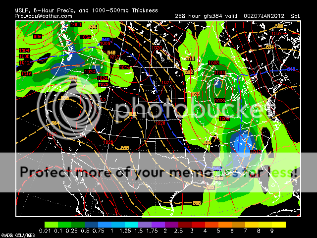
just getting back from nashville from my inlaws for xmas... models are agreeing with cold around or just after new years... go to love the height of the ridge in west, and the trough diggin down over the east... that is a prime setup for a gulf low to develop on the southern part of that trough.. something to look for as we get just beyond the newyears period. i have also seen someone post the nao chart over on another forum and it really goes negative around the 6th of january.,, usually when you get a pattern change with the teleconections a big time storm usually forms.Cyclonicjunkie wrote:Oh yeah the 12z euro still has the very cold sytem it may be time for another thread for the New years threat...look how tall that ridge is out west
tennessee storm09- Severe Wx Specialist
- Posts : 1304
Join date : 2011-12-05
Age : 61
Location : jackson,tennessee(home of 3 ef4 tornadoes since 1999)
Re: Winter 2011/2012 Pattern Discussion
![]() by tennessee storm09 2011-12-25, 7:03 pm
by tennessee storm09 2011-12-25, 7:03 pm

tennessee storm09- Severe Wx Specialist
- Posts : 1304
Join date : 2011-12-05
Age : 61
Location : jackson,tennessee(home of 3 ef4 tornadoes since 1999)
Re: Winter 2011/2012 Pattern Discussion
![]() by Stovepipe 2011-12-25, 8:57 pm
by Stovepipe 2011-12-25, 8:57 pm
tennessee storm09 wrote:if i happen to miss spell anything on my last post, i am so sorry cause i have had a couple of strong adult beverages for christmas.
Join the club, merry Christmas!

Stovepipe- Founding Member
- Posts : 4148
Join date : 2011-12-05
Age : 48
Location : Knoxville, TN -
Re: Winter 2011/2012 Pattern Discussion
![]() by tennessee storm09 2011-12-25, 9:26 pm
by tennessee storm09 2011-12-25, 9:26 pm
thanks stove, same to you and your family.Stovepipe wrote:tennessee storm09 wrote:if i happen to miss spell anything on my last post, i am so sorry cause i have had a couple of strong adult beverages for christmas.
Join the club, merry Christmas!
tennessee storm09- Severe Wx Specialist
- Posts : 1304
Join date : 2011-12-05
Age : 61
Location : jackson,tennessee(home of 3 ef4 tornadoes since 1999)
Re: Winter 2011/2012 Pattern Discussion
![]() by Toot 2011-12-25, 10:22 pm
by Toot 2011-12-25, 10:22 pm
tennessee storm09 wrote:
just getting back from nashville from my inlaws for xmas... models are agreeing with cold around or just after new years... go to love the height of the ridge in west, and the trough diggin down over the east... that is a prime setup for a gulf low to develop on the southern part of that trough.. something to look for as we get just beyond the newyears period. i have also seen someone post the nao chart over on another forum and it really goes negative around the 6th of january.,, usually when you get a pattern change with the teleconections a big time storm usually forms.
IF that euro is correct....climo and I say this could be the one lizabeth

Last edited by Cyclonicjunkie on 2011-12-25, 10:35 pm; edited 1 time in total
Toot- La Vida Loca
- Posts : 6644
Join date : 2011-12-05
Location : Cocke County, TN -

Reb- Admin
- Posts : 745
Join date : 2011-12-05
Location : Maryville, TN
Re: Winter 2011/2012 Pattern Discussion
![]() by Toot 2011-12-25, 10:30 pm
by Toot 2011-12-25, 10:30 pm
Toot- La Vida Loca
- Posts : 6644
Join date : 2011-12-05
Location : Cocke County, TN -
Re: Winter 2011/2012 Pattern Discussion
![]() by Stovepipe 2011-12-26, 1:33 am
by Stovepipe 2011-12-26, 1:33 am
Stovepipe- Founding Member
- Posts : 4148
Join date : 2011-12-05
Age : 48
Location : Knoxville, TN -
Page 10 of 37 • 1 ... 6 ... 9, 10, 11 ... 23 ... 37 ![]()
» Is winter over? Very weird pattern going on!!
» Winter wx Discussion 2015/16
» Winter Wx Discussion 2013/14
» Winter Wx Discussion 2014/2015


