


Winter 2011/2012 Pattern Discussion
Page 9 of 37 •  1 ... 6 ... 8, 9, 10 ... 23 ... 37
 ![]()
Re: Winter 2011/2012 Pattern Discussion
![]() by Stovepipe 2011-12-20, 12:56 pm
by Stovepipe 2011-12-20, 12:56 pm
snowdog wrote:Hope everyone is ready for spring. After Xmas it looks like spring officially kicks off. To heck with Winter 2012. I think the Mayan calendar not only predicted the end of the world in 2012 but also the end of winter in North America in 2012. There is not one shred of evidence to hang your hat on right now if you are hoping for a turnaround. Fugly.

What shred of evidence do you have that winter is over? I hope you aren't basing your prediction on the ultra reliable long range forecasts of the GFS. Because that would just be silly considering it's track record recently. It's still finding and losing storms daily for the Christmas time frame for crying out loud. We are seeing two to three systems PER WEEK roll through the area. Odds are one of them is going to get hung up in some cold air before long, regardless of what "pattern" we are in. It was still December last time I checked.
Again for good measure:


Stovepipe- Founding Member
- Posts : 4148
Join date : 2011-12-05
Age : 48
Location : Knoxville, TN -

Re: Winter 2011/2012 Pattern Discussion
![]() by snowdog 2011-12-20, 1:47 pm
by snowdog 2011-12-20, 1:47 pm
snowdog- Winter Specialist
- Posts : 855
Join date : 2011-12-14
Age : 46
Location : Mount Juliet, TN
Re: Winter 2011/2012 Pattern Discussion
![]() by jmundie 2011-12-20, 3:03 pm
by jmundie 2011-12-20, 3:03 pm
Basically, we're gonna be watching this one up until it happens it seems. Modeling is beyond horrible.
jmundie- Winter Specialist
- Posts : 743
Join date : 2011-12-19
Re: Winter 2011/2012 Pattern Discussion
![]() by Toot 2011-12-20, 6:48 pm
by Toot 2011-12-20, 6:48 pm
snowdog wrote:Hope everyone is ready for spring. After Xmas it looks like spring officially kicks off. To heck with Winter 2012. I think the Mayan calendar not only predicted the end of the world in 2012 but also the end of winter in North America in 2012. There is not one shred of evidence to hang your hat on right now if you are hoping for a turnaround. Fugly.

Toot- La Vida Loca
- Posts : 6644
Join date : 2011-12-05
Location : Cocke County, TN -
Re: Winter 2011/2012 Pattern Discussion
![]() by tennessee storm09 2011-12-20, 8:34 pm
by tennessee storm09 2011-12-20, 8:34 pm
i am not ready to throw the towel in by no means, but i am worried about this long range pattern... and im not basing this off any gfs models either... but if this is the case about this winter not going to pan out, yes bring me the spring severe weather early... i think we are heading into a explosive late winter early spring severe season.. i will be updating more on the severe aspect in my playhouse toot made for me.snowdog wrote:Hope everyone is ready for spring. After Xmas it looks like spring officially kicks off. To heck with Winter 2012. I think the Mayan calendar not only predicted the end of the world in 2012 but also the end of winter in North America in 2012. There is not one shred of evidence to hang your hat on right now if you are hoping for a turnaround. Fugly.

tennessee storm09- Severe Wx Specialist
- Posts : 1304
Join date : 2011-12-05
Age : 61
Location : jackson,tennessee(home of 3 ef4 tornadoes since 1999)
Re: Winter 2011/2012 Pattern Discussion
![]() by Toot 2011-12-20, 8:57 pm
by Toot 2011-12-20, 8:57 pm
No big changes in the "here today gone tomorrow" weather pattern locally.... but thats not to say we cant get winter weather because we can..there's just not going to be ANY weather pattern that locks in here (cold or warm) without some sort of high lattitude blocking. You end up getting a trough and then a ridge and a trough and then a ridge etc etc etc etc etc

The PV feature moving out of the Greenland area is a step in the right direction though...NAO blocking would have been hard pressed to form in close vicinity to such a powerful vortex of lower heights
Toot- La Vida Loca
- Posts : 6644
Join date : 2011-12-05
Location : Cocke County, TN -
Re: Winter 2011/2012 Pattern Discussion
![]() by snowdog 2011-12-21, 8:23 am
by snowdog 2011-12-21, 8:23 am
snowdog- Winter Specialist
- Posts : 855
Join date : 2011-12-14
Age : 46
Location : Mount Juliet, TN
Re: Winter 2011/2012 Pattern Discussion
![]() by Adam2014 2011-12-21, 8:33 am
by Adam2014 2011-12-21, 8:33 am

Adam2014- Founding Member
- Posts : 1424
Join date : 2011-12-05
Age : 28
Location : Lawrenceburg,TN
Re: Winter 2011/2012 Pattern Discussion
![]() by Adam2014 2011-12-21, 8:34 am
by Adam2014 2011-12-21, 8:34 am
Adam2014- Founding Member
- Posts : 1424
Join date : 2011-12-05
Age : 28
Location : Lawrenceburg,TN
Re: Winter 2011/2012 Pattern Discussion
![]() by snowdog 2011-12-21, 8:49 am
by snowdog 2011-12-21, 8:49 am
Adam2014 wrote:For what it is worth, the EURO is trying to get the Pacific Firehose look through hour 180.
A strong -PDO usually favors just that, along with a -PNA.
snowdog- Winter Specialist
- Posts : 855
Join date : 2011-12-14
Age : 46
Location : Mount Juliet, TN
Re: Winter 2011/2012 Pattern Discussion
![]() by Adam2014 2011-12-21, 9:47 am
by Adam2014 2011-12-21, 9:47 am
Well it looks good.snowdog wrote:Adam2014 wrote:For what it is worth, the EURO is trying to get the Pacific Firehose look through hour 180.
A strong -PDO usually favors just that, along with a -PNA.
Adam2014- Founding Member
- Posts : 1424
Join date : 2011-12-05
Age : 28
Location : Lawrenceburg,TN

Stovepipe- Founding Member
- Posts : 4148
Join date : 2011-12-05
Age : 48
Location : Knoxville, TN -
Re: Winter 2011/2012 Pattern Discussion
![]() by Toot 2011-12-21, 4:58 pm
by Toot 2011-12-21, 4:58 pm
Toot- La Vida Loca
- Posts : 6644
Join date : 2011-12-05
Location : Cocke County, TN -
Re: Winter 2011/2012 Pattern Discussion
![]() by Toot 2011-12-22, 7:38 am
by Toot 2011-12-22, 7:38 am


Toot- La Vida Loca
- Posts : 6644
Join date : 2011-12-05
Location : Cocke County, TN -
Re: Winter 2011/2012 Pattern Discussion
![]() by jmundie 2011-12-22, 7:47 am
by jmundie 2011-12-22, 7:47 am
jmundie- Winter Specialist
- Posts : 743
Join date : 2011-12-19
Re: Winter 2011/2012 Pattern Discussion
![]() by Toot 2011-12-22, 7:50 am
by Toot 2011-12-22, 7:50 am


Toot- La Vida Loca
- Posts : 6644
Join date : 2011-12-05
Location : Cocke County, TN -
Re: Winter 2011/2012 Pattern Discussion
![]() by snowdog 2011-12-22, 8:46 am
by snowdog 2011-12-22, 8:46 am
PNA is measured by basically taking a weighted differential of heights at the 500 mb level from the areas I have marked below. Using the Wallace/Gutzler equation.

NAO is measured by taking the SLP (Sea Level Pressure) difference between the points in the map below. For our purposes here in the southeast we would want more of a west based NAO so we would want the height anomaly around the southern tip of Greenland.

snowdog- Winter Specialist
- Posts : 855
Join date : 2011-12-14
Age : 46
Location : Mount Juliet, TN
Re: Winter 2011/2012 Pattern Discussion
![]() by Stovepipe 2011-12-22, 1:39 pm
by Stovepipe 2011-12-22, 1:39 pm
I see some hope in that run. First, there's no sign to digging southwest Cutoffs. As long as they don't reappear, then we should avoid days like today, with strong southwest flow and well above normal warmth. Instead , it remains mostly zonal, with stratified temps and maybe temps holding a smidge above normal most days around here. Then in about a week, it develops briefly negative NAO and maybe blocking just north of Greenland, but there's not a huge sign of that. But the other big news is that it wants to carve out Eastern Trough at times. Thats the alarm bell right there..because without the pesky southwest lows, we'll open the door for the Arctic (or atleast colder air) to move more in our direction instead of the Rockies and western Plains thats been going on for so long now. And I have little doubt at all that one (or several) of the shortwaves will indeed amp up for us, and carve out more major systems, but the only question or doubt in my mind is where they do it. If its the Southwest or southern Rockies again, we'll keep repeating what we have. If its further east...Oh boy! could get fun. Just look how often the west has gone between warmth, then a low hits from the right direction and snow resulted. Same for Tenn. Valley earlier. But I'm not sold on where just yet. ...just a couple good possible signs I'm seeing as we enter January.
Stovepipe- Founding Member
- Posts : 4148
Join date : 2011-12-05
Age : 48
Location : Knoxville, TN -
Re: Winter 2011/2012 Pattern Discussion
![]() by Toot 2011-12-22, 4:19 pm
by Toot 2011-12-22, 4:19 pm
jmundie wrote:You guys noticed the ensemble agreement around 10 days some a moisture rich bowling ball ull coming down the plains into the southeast. It's been showing up in the ensembles pretty consistently for the last couple days.
Yep...not sure exactly how this system will play out but im really wanting to jump on board this timeframe for the first widespread wintry event here in TN...im gonna set back and watch models for a few more days but it appears that this will be a more legit threat...with alot of indices forcasted to become favorable. I just cant believe all those forecasters have changed their whole winter forecast for nothing more than a relatively warm December

Toot- La Vida Loca
- Posts : 6644
Join date : 2011-12-05
Location : Cocke County, TN -
Re: Winter 2011/2012 Pattern Discussion
![]() by Stovepipe 2011-12-22, 9:05 pm
by Stovepipe 2011-12-22, 9:05 pm

Also, man that is a serious low approaching Alaska at 276. Is that 12 contours I count?

Stovepipe- Founding Member
- Posts : 4148
Join date : 2011-12-05
Age : 48
Location : Knoxville, TN -
Re: Winter 2011/2012 Pattern Discussion
![]() by Toot 2011-12-23, 1:12 am
by Toot 2011-12-23, 1:12 am
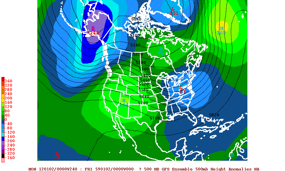
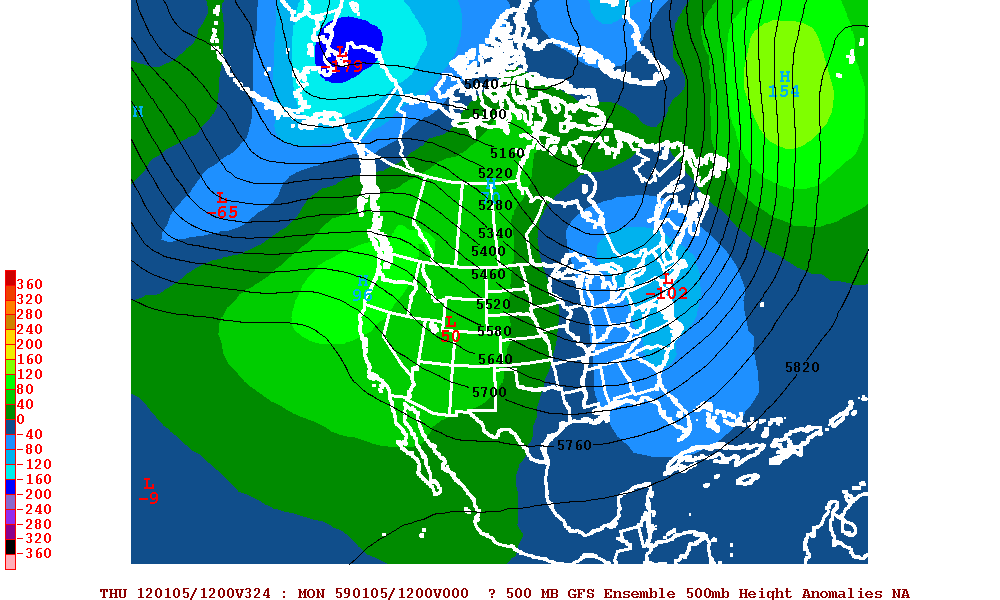
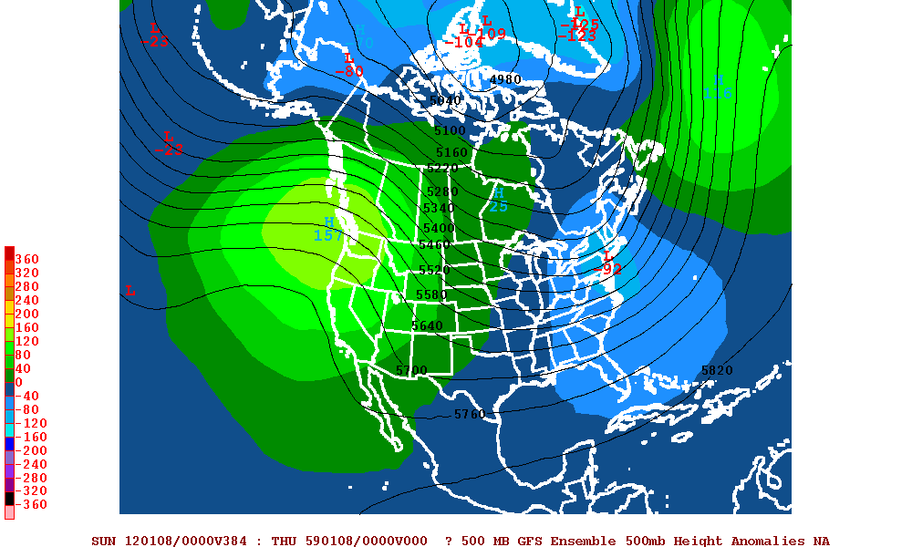
Here is the mean centered over North America
Dec 31
Jan 2

Jan 5
Jan 8
Fun Times look to be ahead
Toot- La Vida Loca
- Posts : 6644
Join date : 2011-12-05
Location : Cocke County, TN -
Re: Winter 2011/2012 Pattern Discussion
![]() by Guest 2011-12-23, 6:49 am
by Guest 2011-12-23, 6:49 am
Guest- Guest
Re: Winter 2011/2012 Pattern Discussion
![]() by jmundie 2011-12-23, 10:06 am
by jmundie 2011-12-23, 10:06 am
I'm with you Toot... I'm not ready to call for a new years storm, but that's certainly a time period that bears watching
jmundie- Winter Specialist
- Posts : 743
Join date : 2011-12-19
Re: Winter 2011/2012 Pattern Discussion
![]() by Toot 2011-12-23, 10:37 am
by Toot 2011-12-23, 10:37 am
jmundie wrote:The ensembles are all over an event of note somewhere in the 180-216 timeframe. I'm surprised not much is showing up on the op. The storms aren't digging on the op, instead, they are moving way to progressively through new england (which has been our problem all winter with the positive nao)
I'm with you Toot... I'm not ready to call for a new years storm, but that's certainly a time period that bears watching
Yep...this could be the first really powerful ULL that in addition to making its own cold air will also be surrounded with decent amounts of cold air Foothills ( AKA Robert Gamble at Amercian wx) has been all over that scenario and im really starting to bite onto his idea...Just Saying
Not sure though...as there will have to be a very powerful cold front around this timeframe if the gfs ensembles are correct with their pattern change and they dont seem to be backing down from their idea anytime soon
Toot- La Vida Loca
- Posts : 6644
Join date : 2011-12-05
Location : Cocke County, TN -
Re: Winter 2011/2012 Pattern Discussion
![]() by Stovepipe 2011-12-23, 11:05 am
by Stovepipe 2011-12-23, 11:05 am
Stovepipe- Founding Member
- Posts : 4148
Join date : 2011-12-05
Age : 48
Location : Knoxville, TN -
Page 9 of 37 • 1 ... 6 ... 8, 9, 10 ... 23 ... 37 ![]()
» Is winter over? Very weird pattern going on!!
» Winter wx Discussion 2015/16
» Winter Wx Discussion 2013/14
» Winter Wx Discussion 2014/2015


