


Feb 13th/14th 2012 Snow/ice Threat
Page 5 of 10 •  1, 2, 3, 4, 5, 6, 7, 8, 9, 10
 ![]()
Re: Feb 13th/14th 2012 Snow/ice Threat
![]() by Stovepipe 2012-02-12, 5:20 pm
by Stovepipe 2012-02-12, 5:20 pm
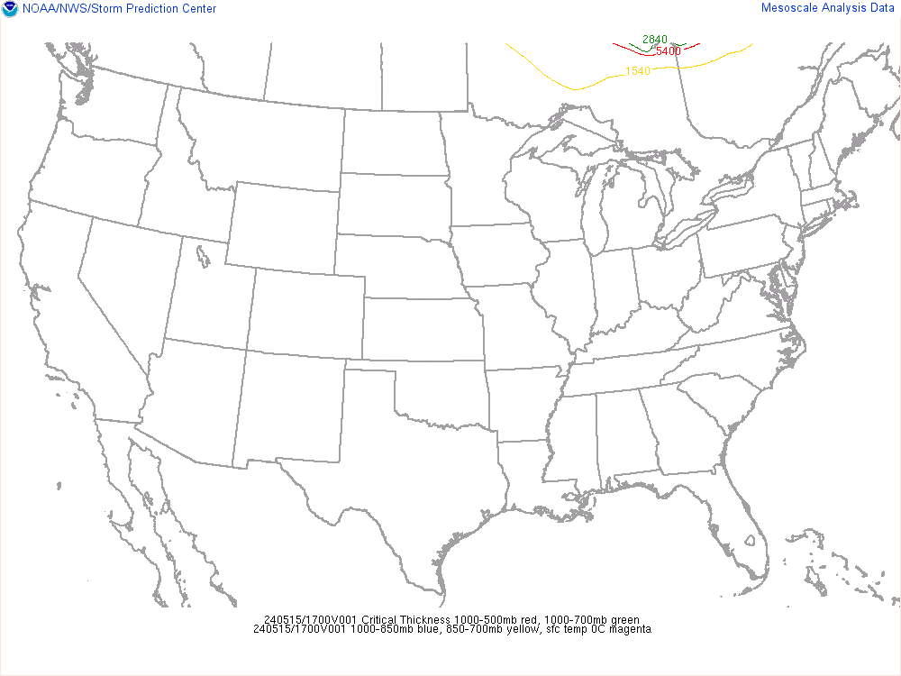
I've been reading that it's possible this thing moves in quicker than the models are showing (and out faster). If that is the case then the chances of more frozen precip are greater. Some have also said that in that scenario there could be "fingers" of precip that streak out ahead of the main batch that could cause some good locally heavy snowfall.
As of right now, I'm not really sure what to expect. I mean when I look at the RPM and WRF I see what appears to be nothing but rain as it moves across TN, getting weaker on the northern fringes with each frame. Then I see things like this:

Which suggest that parts of north GA may not even transition all the way back to rain. Such a difficult event to forecast. I'm very curious to see how this plays out. Honestly I'll be shocked if I wake up to wintry precip Tuesday morning here in the valley. But stranger things have happened.

Stovepipe- Founding Member
- Posts : 4148
Join date : 2011-12-05
Age : 48
Location : Knoxville, TN -

Re: Feb 13th/14th 2012 Snow/ice Threat
![]() by Toot 2012-02-12, 5:21 pm
by Toot 2012-02-12, 5:21 pm

Toot- La Vida Loca
- Posts : 6644
Join date : 2011-12-05
Location : Cocke County, TN -
Re: Feb 13th/14th 2012 Snow/ice Threat
![]() by Toot 2012-02-12, 5:24 pm
by Toot 2012-02-12, 5:24 pm

Toot- La Vida Loca
- Posts : 6644
Join date : 2011-12-05
Location : Cocke County, TN -
Re: Feb 13th/14th 2012 Snow/ice Threat
![]() by John1122 2012-02-12, 5:29 pm
by John1122 2012-02-12, 5:29 pm
The timing sort of stinks with it. We'll be clouding up during the absolute warmest part of the day, which will help hold temps up at night in an already iffy situation.
John1122- Winter Specialist
- Posts : 885
Join date : 2011-12-06
Location : Campbell Co
Re: Feb 13th/14th 2012 Snow/ice Threat
![]() by Toot 2012-02-12, 5:35 pm
by Toot 2012-02-12, 5:35 pm

Toot- La Vida Loca
- Posts : 6644
Join date : 2011-12-05
Location : Cocke County, TN -
Re: Feb 13th/14th 2012 Snow/ice Threat
![]() by tennessee storm09 2012-02-12, 5:42 pm
by tennessee storm09 2012-02-12, 5:42 pm
 funny as hell
tennessee storm09- Severe Wx Specialist
- Posts : 1304
Join date : 2011-12-05
Age : 61
Location : jackson,tennessee(home of 3 ef4 tornadoes since 1999)
Re: Feb 13th/14th 2012 Snow/ice Threat
![]() by Stovepipe 2012-02-12, 6:05 pm
by Stovepipe 2012-02-12, 6:05 pm
tennessee storm09 wrote:they are about have another melt down over at the other forum

Stovepipe- Founding Member
- Posts : 4148
Join date : 2011-12-05
Age : 48
Location : Knoxville, TN -
Re: Feb 13th/14th 2012 Snow/ice Threat
![]() by Dyersburg Weather 2012-02-12, 6:10 pm
by Dyersburg Weather 2012-02-12, 6:10 pm
tennessee storm09 wrote:they are about have another melt down over at the other forum
Someone can move this post if need be but I refuse to post on that other site you mention. Seems that if you are not in the click, you better not disagree or question them.

Dyersburg Weather- Banned
- Posts : 342
Join date : 2011-12-25
Age : 55
Location : Dyersburg , TN
Toot- La Vida Loca
- Posts : 6644
Join date : 2011-12-05
Location : Cocke County, TN -
Re: Feb 13th/14th 2012 Snow/ice Threat
![]() by Toot 2012-02-12, 6:23 pm
by Toot 2012-02-12, 6:23 pm


Toot- La Vida Loca
- Posts : 6644
Join date : 2011-12-05
Location : Cocke County, TN -
Re: Feb 13th/14th 2012 Snow/ice Threat
![]() by John1122 2012-02-12, 6:31 pm
by John1122 2012-02-12, 6:31 pm
The area where than snow is falling is 2500-3500 feet in elevation mostly. 546 is in play at those elevations.
John1122- Winter Specialist
- Posts : 885
Join date : 2011-12-06
Location : Campbell Co
Re: Feb 13th/14th 2012 Snow/ice Threat
![]() by Toot 2012-02-12, 6:38 pm
by Toot 2012-02-12, 6:38 pm
Toot- La Vida Loca
- Posts : 6644
Join date : 2011-12-05
Location : Cocke County, TN -
Re: Feb 13th/14th 2012 Snow/ice Threat
![]() by Toot 2012-02-12, 6:41 pm
by Toot 2012-02-12, 6:41 pm


Toot- La Vida Loca
- Posts : 6644
Join date : 2011-12-05
Location : Cocke County, TN -
Re: Feb 13th/14th 2012 Snow/ice Threat
![]() by tennessee storm09 2012-02-12, 6:44 pm
by tennessee storm09 2012-02-12, 6:44 pm
lmfao, dude, thats a classic there stove... i didnt mean to get off the snow topic... sorryStovepipe wrote:
tennessee storm09- Severe Wx Specialist
- Posts : 1304
Join date : 2011-12-05
Age : 61
Location : jackson,tennessee(home of 3 ef4 tornadoes since 1999)
Re: Feb 13th/14th 2012 Snow/ice Threat
![]() by Toot 2012-02-12, 6:46 pm
by Toot 2012-02-12, 6:46 pm

Toot- La Vida Loca
- Posts : 6644
Join date : 2011-12-05
Location : Cocke County, TN -
Re: Feb 13th/14th 2012 Snow/ice Threat
![]() by tennessee storm09 2012-02-12, 6:54 pm
by tennessee storm09 2012-02-12, 6:54 pm
toot, spc seems thee could be some thunderstorm activity down to the south, could this enhance our precip with extra lift here... or could that hurt us with more waa pushing up from the south... interesting indeed.. foothills has a good explanation on this system by the way.Toot wrote:The biggest problem I see is the dry air....you may very well be cold enough but by the time the virga works itself down to the surface then you may be too warm...its a touch and go situation here in TN
tennessee storm09- Severe Wx Specialist
- Posts : 1304
Join date : 2011-12-05
Age : 61
Location : jackson,tennessee(home of 3 ef4 tornadoes since 1999)
Re: Feb 13th/14th 2012 Snow/ice Threat
![]() by skillsweather 2012-02-12, 7:03 pm
by skillsweather 2012-02-12, 7:03 pm
Dyersburg Weather wrote:tennessee storm09 wrote:they are about have another melt down over at the other forum
Someone can move this post if need be but I refuse to post on that other site you mention. Seems that if you are not in the click, you better not disagree or question them.
Thats exactly how it is there I even told one of the admins over there in pm and they said if I dont like the way its run over there I have the right to leave. So I did somewhat lol.
But yea News 2 basically is calling this as a rain mixed with sleet and a few snow flakes changing to all rain during the night as warmer air makes its way it. I so hope they eat them words tomorrow afternoon when were looking at 1-3inches.
skillsweather- Banned
- Posts : 313
Join date : 2011-12-06
Age : 32
Location : tennessee Wilson county Ne Corner
Re: Feb 13th/14th 2012 Snow/ice Threat
![]() by Toot 2012-02-12, 7:14 pm
by Toot 2012-02-12, 7:14 pm
tennessee storm09 wrote:toot, spc seems thee could be some thunderstorm activity down to the south, could this enhance our precip with extra lift here... or could that hurt us with more waa pushing up from the south... interesting indeed.. foothills has a good explanation on this system by the way.
It really depends on how fast it takes warm air advection to do its dirty work. Places in southern TN COULD benefit from the deep moisture around the very convective activity to its south. Its a very complex system and im not sure any one forecaster or forecast office is completely correct. One model shows this....one model shows that. With that said...any unelevated snow accumulations are looking very light IMO.
Toot- La Vida Loca
- Posts : 6644
Join date : 2011-12-05
Location : Cocke County, TN -
Re: Feb 13th/14th 2012 Snow/ice Threat
![]() by Adam2014 2012-02-12, 7:51 pm
by Adam2014 2012-02-12, 7:51 pm

Adam2014- Founding Member
- Posts : 1424
Join date : 2011-12-05
Age : 28
Location : Lawrenceburg,TN

Toot- La Vida Loca
- Posts : 6644
Join date : 2011-12-05
Location : Cocke County, TN -
Re: Feb 13th/14th 2012 Snow/ice Threat
![]() by tennessee storm09 2012-02-12, 9:36 pm
by tennessee storm09 2012-02-12, 9:36 pm
man, what a set of lips on a woman...Toot wrote:
lol...im an idiot!!
 .
.
tennessee storm09- Severe Wx Specialist
- Posts : 1304
Join date : 2011-12-05
Age : 61
Location : jackson,tennessee(home of 3 ef4 tornadoes since 1999)
Stovepipe- Founding Member
- Posts : 4148
Join date : 2011-12-05
Age : 48
Location : Knoxville, TN -
Re: Feb 13th/14th 2012 Snow/ice Threat
![]() by Dyersburg Weather 2012-02-12, 9:50 pm
by Dyersburg Weather 2012-02-12, 9:50 pm
Toot wrote:
lol...im an idiot!!
Now come and clean the beer off of my screen.
Dyersburg Weather- Banned
- Posts : 342
Join date : 2011-12-25
Age : 55
Location : Dyersburg , TN
Re: Feb 13th/14th 2012 Snow/ice Threat
![]() by tennessee storm09 2012-02-12, 9:54 pm
by tennessee storm09 2012-02-12, 9:54 pm
tennessee storm09- Severe Wx Specialist
- Posts : 1304
Join date : 2011-12-05
Age : 61
Location : jackson,tennessee(home of 3 ef4 tornadoes since 1999)
Re: Feb 13th/14th 2012 Snow/ice Threat
![]() by tennessee storm09 2012-02-12, 10:04 pm
by tennessee storm09 2012-02-12, 10:04 pm
tennessee storm09- Severe Wx Specialist
- Posts : 1304
Join date : 2011-12-05
Age : 61
Location : jackson,tennessee(home of 3 ef4 tornadoes since 1999)
Page 5 of 10 • 1, 2, 3, 4, 5, 6, 7, 8, 9, 10 ![]()
» strong to severe storms poss on the 13th and 14th..
» Early FEB snow threat
» Jan 13-15 Arctic Boundary Ice/Sleet/Snow/Flooding threat
» Febuary 24-26 2012 arctic front and snow potential


