
WRF cast

Satellite Loop

Current Snow Cover

Conus Radar

Regional Radar

Tennessee Radar

SE RADAR

24 hr Temp change

Regional Temps

Conus Temps

Current CPC NAO and forecast

Winter Storm Threat 16th-18th
+16
Jscentraltn
Pamphobeteus
fire rescue87
Math/Met
Grandpa Nasty
bigbris
weatherbob
realdeal2414
snowman72
etnwx
windstorm
Jed33
ashleyj89
Toot
Pman1618
Neals
20 posters
Page 3 of 10
Page 3 of 10 •  1, 2, 3, 4, 5, 6, 7, 8, 9, 10
 ![]()
Re: Winter Storm Threat 16th-18th
![]() by weatherbob 2015-02-12, 10:54 pm
by weatherbob 2015-02-12, 10:54 pm
Here's the color bar in inches[img] [/img]
[/img]
weatherbob- Member
- Posts : 28
Join date : 2015-02-12
Re: Winter Storm Threat 16th-18th
![]() by Jed33 2015-02-13, 5:49 am
by Jed33 2015-02-13, 5:49 am
Better hope the euro and ukmet are right cause the gfs just keeps going south with the second wave. Hardly any wintry precip now with it. Another thing we could hope for is the front wave Sunday night into Mon. It looked better at 6z and gave most of the state 2-4in. Looks like the HP coming in behind the front wave is responsible for pushing it down so far. At this range its still unclear what will happen. However, someone correct me if I'm wrong, but I believe the euro has the hand normally in the 3-4 day range. It's usually in it's wheelhouse. The gfs has some nice features, but it's too inconsistent for my liking. Of note, there is another mega clipper behind this. It's track is most certainly modeled too far sw on the 6z gfs as it would be a clipper travelling through MS and AL. Don't believe ive ever seen a clipper that far sw. It may have happened, but it's really rare. In any case, here we are in late winter, and we are experiencing a mid winter pattern. Crazy huh?
Jed33- Admin
- Posts : 930
Join date : 2011-12-09
Location : Morristown, TN
Re: Winter Storm Threat 16th-18th
![]() by Jscentraltn 2015-02-13, 6:00 am
by Jscentraltn 2015-02-13, 6:00 am
Yeah!! Pretty crazy..... I think our only hope is going to be a stronger system for sun night - mon time window... But the models are now pretty progressive even with it. The stronger the first wave is will cause the second one further south and weaker, the weaker the first wave the stronger and further north for the second... It will prob will be inbetween the gfs and euro, so 2-4 seem poss as of now! STRONGER and SLOWER is what we need. But hey I'm not surprised by the trend..

Jscentraltn- Admin
- Posts : 703
Join date : 2013-01-19
Age : 45
Location : Cheatham county
Re: Winter Storm Threat 16th-18th
![]() by Jscentraltn 2015-02-13, 6:27 am
by Jscentraltn 2015-02-13, 6:27 am
After looking at some things, I still think the models do not have a good handle on this storm yet.... So many factors involved, I look for a lot more moisture than what is modeled to be involved with it, we will see, after all it still over 70 hrs out! Off to work!!!!!!
Jscentraltn- Admin
- Posts : 703
Join date : 2013-01-19
Age : 45
Location : Cheatham county
Jed33- Admin
- Posts : 930
Join date : 2011-12-09
Location : Morristown, TN
Re: Winter Storm Threat 16th-18th
![]() by Toot 2015-02-13, 7:39 am
by Toot 2015-02-13, 7:39 am
Looks pretty good as far as the track of surface low


Toot- La Vida Loca
- Posts : 6644
Join date : 2011-12-05
Location : Cocke County, TN -

Re: Winter Storm Threat 16th-18th
![]() by Jed33 2015-02-13, 8:16 am
by Jed33 2015-02-13, 8:16 am
The GFS op doesn't make since to me. There should be a stripe of wintry precip at the north side, no matter how far it is suppressed, unless it goes to Cuba lol
Jed33- Admin
- Posts : 930
Join date : 2011-12-09
Location : Morristown, TN
Re: Winter Storm Threat 16th-18th
![]() by windstorm 2015-02-13, 8:39 am
by windstorm 2015-02-13, 8:39 am
- Code:
THE NEXT SYSTEM OF CONCERN WILL BE A SYSTEM MOVING THROUGH MONDAY
INTO TUESDAY.  MODELS IN VERY POOR AGREEMENT IN TIMING AND TRACK OF
THE SYSTEM.  CONFIDENCE IS VERY LOW WITH THIS SYSTEM.  CURRENT RUN
OF THE NAM KEEPS THE COLD AIR IN PLACE AS THE SYSTEM MOVES THROUGH.
THIS SCENARIO COULD BRING A COUPLE TO SEVERAL INCHES OF SNOW EVEN
THE LOWER ELEVATIONS.  THE GFS RUN HAS TRENDED TO A COLDER AIR MASS
BUT ALSO KEEPS THE MAIN BAND OF MOISTURE TO OUR SOUTH WHICH WOULD
LIMIT SNOWFALL AMOUNTS.  PRIOR RUNS BROUGHT WARMER AIR AND DEEPER
MOISTURE INTO THE REGION PROVIDING A RAIN SNOW MIX.  HAVE TRENDED
WITH COLDER TEMPERATURES BUT THE ONLY PLACE CONFIDENCE IS REASONABLE
FOR DECENT SNOWFALL IS ACROSS HIGHER ELEVATIONS...GENERALLY ABOVE
3000 FEET.  THROUGH THE REST OF THE EXTENDED...CONFIDENCE REMAINS
LOW BUT EXPECT TO SEE ADDITIONAL SURGES OF COLD AIR AND AT LEAST ONE
MORE LOW PRESSURE MOVING THROUGH FOR CONTINUED COLD TEMPERATURES AND
A CHANCE OF SNOW.
Last edited by Toot on 2015-02-13, 8:59 am; edited 1 time in total (Reason for editing : Straighten format up)

windstorm- Member
- Posts : 891
Join date : 2012-03-26
Location : Harrison, tn
Re: Winter Storm Threat 16th-18th
![]() by Toot 2015-02-13, 8:56 am
by Toot 2015-02-13, 8:56 am
Jed33 wrote:The GFS op doesn't make since to me. There should be a stripe of wintry precip at the north side, no matter how far it is suppressed, unless it goes to Cuba lol
Its pretty much in disagreement with its own ensembles too..lol
6zGEFS MEAN total snowfall

Toot- La Vida Loca
- Posts : 6644
Join date : 2011-12-05
Location : Cocke County, TN -

Toot- La Vida Loca
- Posts : 6644
Join date : 2011-12-05
Location : Cocke County, TN -
etnvolman- Member
- Posts : 23
Join date : 2013-02-08
Age : 54
Location : sevierville,tn


windstorm- Member
- Posts : 891
Join date : 2012-03-26
Location : Harrison, tn
Re: Winter Storm Threat 16th-18th
![]() by windstorm 2015-02-13, 11:03 am
by windstorm 2015-02-13, 11:03 am
If it going to happen the NWS needs to get on the ball. They should know by Sunday anyway. Have a great weekend everyone . Happy Friday the 13th. JB is supporting something like that also.
windstorm- Member
- Posts : 891
Join date : 2012-03-26
Location : Harrison, tn
Re: Winter Storm Threat 16th-18th
![]() by Math/Met 2015-02-13, 12:42 pm
by Math/Met 2015-02-13, 12:42 pm
The 12z GEFS Mean still looks good for Tennessee as well.
Math/Met- Meteorologist
- Posts : 226
Join date : 2011-12-05
Re: Winter Storm Threat 16th-18th
![]() by Toot 2015-02-13, 12:56 pm
by Toot 2015-02-13, 12:56 pm
Math/Met wrote:The 12z GEFS Mean still looks good for Tennessee as well.
Sure does!!

Toot- La Vida Loca
- Posts : 6644
Join date : 2011-12-05
Location : Cocke County, TN -

Toot- La Vida Loca
- Posts : 6644
Join date : 2011-12-05
Location : Cocke County, TN -
Re: Winter Storm Threat 16th-18th
![]() by Toot 2015-02-13, 2:16 pm
by Toot 2015-02-13, 2:16 pm
The outlier..the operational GFS did try and bring it back north today but mostly still a near miss except for extreme E.TN! The GFS also has second wave behind this one...lol

Toot- La Vida Loca
- Posts : 6644
Join date : 2011-12-05
Location : Cocke County, TN -
Re: Winter Storm Threat 16th-18th
![]() by Math/Met 2015-02-13, 2:55 pm
by Math/Met 2015-02-13, 2:55 pm
That Eurowx.com map is using 14:1 ratios for KTYS to get 8.8 inches of snow. Considering the surface temperatures are modeled to be in the low 20’s and 925/850mb temps are expected to be around -6C, I’d say a 14:1 ratio seems reasonable with light winds in the lower levels.
Math/Met- Meteorologist
- Posts : 226
Join date : 2011-12-05

Math/Met- Meteorologist
- Posts : 226
Join date : 2011-12-05
Re: Winter Storm Threat 16th-18th
![]() by Toot 2015-02-13, 5:59 pm
by Toot 2015-02-13, 5:59 pm
Lol...And the evening run of the GFS model weighs in on the situation. It even has a second wave that comes directly behind the early week event! Top is early week and bottom is after second wave rolls thru by late week


Toot- La Vida Loca
- Posts : 6644
Join date : 2011-12-05
Location : Cocke County, TN -
Re: Winter Storm Threat 16th-18th
![]() by Jed33 2015-02-13, 6:52 pm
by Jed33 2015-02-13, 6:52 pm
Right or wrong, the GfS bounces around an aweful lot
Jed33- Admin
- Posts : 930
Join date : 2011-12-09
Location : Morristown, TN
Re: Winter Storm Threat 16th-18th
![]() by Neals 2015-02-13, 8:27 pm
by Neals 2015-02-13, 8:27 pm
Wow, toot. That is awesome. I really would like to see that verify. We would have one of the old school winter wonderlands.
Neals- Member
- Posts : 233
Join date : 2012-10-28
Location : Cocke
Re: Winter Storm Threat 16th-18th
![]() by Neals 2015-02-13, 8:49 pm
by Neals 2015-02-13, 8:49 pm
Wait a minute. That's the same picture isn't it?
Neals- Member
- Posts : 233
Join date : 2012-10-28
Location : Cocke
Re: Winter Storm Threat 16th-18th
![]() by weatherbob 2015-02-13, 9:00 pm
by weatherbob 2015-02-13, 9:00 pm
Here's the NAM snowfall total [img]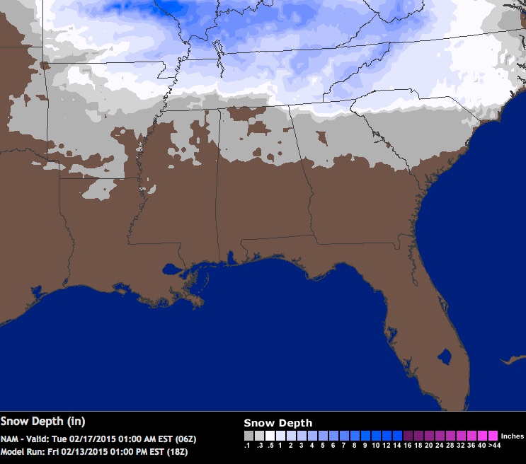 [/img] from weathtrap
[/img] from weathtrap
weatherbob- Member
- Posts : 28
Join date : 2015-02-12
Re: Winter Storm Threat 16th-18th
![]() by Neals 2015-02-13, 9:09 pm
by Neals 2015-02-13, 9:09 pm
Weatherbob, you have interesting weather maps. Glad to have you as part of the crew.
Neals- Member
- Posts : 233
Join date : 2012-10-28
Location : Cocke
Page 3 of 10 • 1, 2, 3, 4, 5, 6, 7, 8, 9, 10 ![]()
» March 5-6th Winter Storm
» Winter Storm Threat 20-22
» BIG DOG winter storm JAN 22-24
» Winter Storm Tracks
» Over Running Winter storm Dec 6-8
» Winter Storm Threat 20-22
» BIG DOG winter storm JAN 22-24
» Winter Storm Tracks
» Over Running Winter storm Dec 6-8
Page 3 of 10
Permissions in this forum:
You cannot reply to topics in this forum


